Attēls:Viceroyalty of the New Spain 1800 (without Philippines).png

Sākotnējais fails (1 600 × 1 192 pikseļi, faila izmērs: 645 KB, MIME tips: image/png)
| Šis fails ir no Vikikrātuves. Tā apraksts no attēla lapas Vikikrātuvē ir parādīts zemāk. Vikikrātuve ir brīvi licencēta failu krātuve. Tu vari tai palīdzēt. |

|
File:Mapa del Virreinato de la Nueva España (1794).svg is a vector version of this file. It should be used in place of this PNG file when not inferior.
File:Viceroyalty of the New Spain 1800 (without Philippines).png → File:Mapa del Virreinato de la Nueva España (1794).svg
For more information, see Help:SVG. |
.svg) |
Kopsavilkums

| Apraksts |
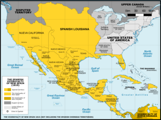
Español: Mapa del Virreinato de Nueva España en 1800. Sin incluir los territorios de ultramar en el Oceano Pacífico.
English: Map of the Viceroyalty of New Spain in 1800. Not including the viceroyalty's overseas territories in the Pacific Ocean.
Territorial organization of the Viceroyalty of New Spain (1535-1786)
Territorial organization of the Viceroyalty of New Spain (1786-1821)
|
||
| Datums | |||
| Avots |
A map created using information from the United States Geological Survey, an agency of the United States Department of Interior 1800, 1810, 1820 and from the Secretary of the Public Education of Mexico (Secretaría de Educación Pública de México) with 500 años de documentos COMMENT on 1 April 2015: The map above is still captioned "1810," instead of 1800. This is unfortunate and confusing, because in 1803 Spanish Louisiana was tranferred (to France and then) to the United States, so it makes the map appear to contain a serious error. ‘’’COMMENT on 13 August 2023: Date on the map above has still not been corrected to the actual year it represents, 1800. This leads to several inaccuracies, including for example misrepresentation of the size of the United States. In 1803 Ohio became a state, so it was no longer a territory by 1810. Such things were quickly changing in the 1800s, and the date on this map should be corrected.’’’ |
||
| Autors | Giggette | ||
| Citas versijas |
|

.png)
.png)
.png?uselang=lv)
.png#Disputed)
| Camera location | | View this and other nearby images on: OpenStreetMap |
|---|
.png¶ms=019.409500_N_-099.130700_E_globe:Earth_type:camera_type:satellite_region:MX_heading:0.00&language=lv)
Licence
- Jūs varat brīvi:
- koplietot – kopēt, izplatīt un pārraidīt darbu
- remiksēt – pielāgot darbu
- Saskaņā ar šādiem nosacījumiem:
- atsaucoties – Tev ir jānorāda autors, saite uz licenci un to, vai veiktas kādas izmaiņas. To var darīt jebkādā saprātīgā veidā, bet ne tādā, kas norādītu, ka licencētājs atbalsta tevi vai veidu, kā tu izmanto šo darbu.
- nemainot licenci – Ja tu miksē, pārveido vai izmanto materiālu, tev savs devums jāpublicē ar to pašu vai saderīgu licenci kā oriģināls.

|
Ir dota atļauja kopēt, izplatīt un/vai pārveidot šo dokumentu saskaņā ar GNU brīvās dokumentācijas licences, versijas 1.2 vai jebkuras vēlākas versijas, ko publiskojis Brīvās programmatūras fonds nosacījumiem; bez nemainīgajām sadaļā, priekšējā un aizmugurēja'vāka tekstiem. Licences kopija ir iekļauta sadaļā ar nosaukumu GNU brīvās dokumentācijas licence. |
Faila hronoloģija
Uzklikšķini uz datums/laiks kolonnā esošās saites, lai apskatītos, kā šis fails izskatījās tad.
| Datums/Laiks | Attēls | Izmēri | Dalībnieks | Komentārs | |
|---|---|---|---|---|---|
| tagadējais | 2016. gada 21. novembris, plkst. 04.42 | | 1 600 × 1 192 (645 KB) | Giggette | Clearest |
| 2014. gada 1. jūnijs, plkst. 22.14 |  | 1 600 × 1 192 (635 KB) | Giggette | Details | |
| 2014. gada 13. maijs, plkst. 22.39 |  | 1 600 × 1 192 (634 KB) | Giggette | Details | |
| 2014. gada 13. maijs, plkst. 22.34 |  | 1 450 × 1 080 (557 KB) | Giggette | Improving the design, adding elements | |
| 2014. gada 12. maijs, plkst. 01.39 |  | 1 501 × 1 117 (549 KB) | Giggette | Adding details, lakes, cities, information | |
| 2014. gada 12. maijs, plkst. 00.41 |  | 1 501 × 1 116 (538 KB) | Giggette | Adding missed provinces and clarifying information | |
| 2014. gada 6. maijs, plkst. 19.54 |  | 1 501 × 1 116 (517 KB) | Giggette | Details | |
| 2014. gada 5. maijs, plkst. 00.38 |  | 1 302 × 971 (450 KB) | Giggette | Details | |
| 2013. gada 6. jūnijs, plkst. 19.33 |  | 1 450 × 1 084 (500 KB) | Giggette | mistake | |
| 2013. gada 6. jūnijs, plkst. 19.30 |  | 1 450 × 1 084 (490 KB) | Giggette | {{Information |Description ={{en|1=x}} |Source ={{own}} |Author =Giggette |Date = |Permission = |other_versions = }} |
Faila lietojums
Šo failu izmanto šajās 12 lapās:
Globālais faila lietojums
Šīs Vikipēdijas izmanto šo failu:
- Izmantojums cs.wikipedia.org
- Izmantojums en.wikipedia.org
- Izmantojums fr.wikipedia.org
- Izmantojums gl.wikipedia.org
- Izmantojums no.wikipedia.org
.png)