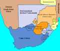
Attēls:SouthAfrica1885.svg

Size of this PNG preview of this SVG file: 716 × 600 pikseļi. Citi izmēri: 287 × 240 pikseļi | 573 × 480 pikseļi | 917 × 768 pikseļi | 1 222 × 1 024 pikseļi | 2 445 × 2 048 pikseļi | 1 713 × 1 435 pikseļi.
Sākotnējais fails (SVG fails, definētais izmērs 1 713 × 1 435 pikseļi, faila izmērs: 79 KB)
Faila hronoloģija
Uzklikšķini uz datums/laiks kolonnā esošās saites, lai apskatītos, kā šis fails izskatījās tad.
| Datums/Laiks | Attēls | Izmēri | Dalībnieks | Komentārs | |
|---|---|---|---|---|---|
| tagadējais | 2022. gada 29. decembris, plkst. 17.27 |  | 1 713 × 1 435 (79 KB) | Lks.poch | File uploaded using svgtranslate tool (https://svgtranslate.toolforge.org/). Added translation for ca. |
| 2022. gada 19. augusts, plkst. 23.28 |  | 1 713 × 1 435 (71 KB) | Dymitr | File uploaded using svgtranslate tool (https://svgtranslate.toolforge.org/). Added translation for be-tarask. | |
| 2022. gada 19. augusts, plkst. 23.28 |  | 1 713 × 1 435 (71 KB) | Dymitr | File uploaded using svgtranslate tool (https://svgtranslate.toolforge.org/). Added translation for be-tarask. | |
| 2022. gada 19. augusts, plkst. 23.22 |  | 1 713 × 1 435 (71 KB) | Dymitr | File uploaded using svgtranslate tool (https://svgtranslate.toolforge.org/). Added translation for be-tarask. | |
| 2022. gada 10. februāris, plkst. 22.41 |  | 1 713 × 1 435 (61 KB) | TheNickFer | File uploaded using svgtranslate tool (https://svgtranslate.toolforge.org/). Added translation for it. | |
| 2022. gada 2. janvāris, plkst. 08.59 |  | 1 713 × 1 435 (53 KB) | Qutlook | File uploaded using svgtranslate tool (https://svgtranslate.toolforge.org/). Added translation for bg. | |
| 2011. gada 21. septembris, plkst. 16.18 |  | 1 713 × 1 435 (47 KB) | Themightyquill | {{Information |Description=Map of South Africa showing British Possessions July 1885 |Source=*File:SouthAfrica1885.jpg |Date=2011-09-21 13:17 (UTC) |Author=*File:SouthAfrica1885.jpg: John George Bartholomew *derivative work: ~~~ |Permissio |
Faila lietojums
Šo failu izmanto šajā 1 lapā:
Globālais faila lietojums
Šīs Vikipēdijas izmanto šo failu:
- Izmantojums af.wikipedia.org
- Izmantojums ar.wikipedia.org
- Izmantojums azb.wikipedia.org
- Izmantojums be-tarask.wikipedia.org
- Izmantojums bg.wikipedia.org
- Izmantojums de.wikipedia.org
- Izmantojums el.wikipedia.org
- Izmantojums en.wikipedia.org
- Second Boer War
- Cape Colony
- History of the Cape Colony from 1870 to 1899
- South African Wars (1879–1915)
- Percy Molteno
- Postage stamps and postal history of South Africa
- User:Queerly Bohemian
- User:Queerly Bohemian/Userboxes/SAWars
- User:Queerly Bohemian/Userboxes
- User:Kiwichris
- User:Sophie Marie Guérin
- User:Srpbm
- User:CarvigoLD
- Wikipedia:Userboxes/History/Military
- User:NatriumGedrogt
- List of governors of British South African colonies
- User:Amir.Vector
- User:SuperSkaterDude45
- User:Searsandrew
- User:Thornfield Hall
- User:RadioactiveBoulevardier/Userboxes
- Izmantojums es.wikipedia.org
- Izmantojums ga.wikipedia.org
- Izmantojums it.wikipedia.org
- Izmantojums ja.wikipedia.org
- Izmantojums nl.wikipedia.org
- Izmantojums ru.wikipedia.org
- Izmantojums simple.wikipedia.org
- Izmantojums sl.wikipedia.org
- Izmantojums zh.wikipedia.org


