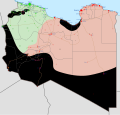
Attēls:Libyan Civil War.svg

Size of this PNG preview of this SVG file: 625 × 600 pikseļi. Citi izmēri: 250 × 240 pikseļi | 500 × 480 pikseļi | 801 × 768 pikseļi | 1 067 × 1 024 pikseļi | 2 135 × 2 048 pikseļi | 1 033 × 991 pikseļi.
Sākotnējais fails (SVG fails, definētais izmērs 1 033 × 991 pikseļi, faila izmērs: 805 KB)
Faila hronoloģija
Uzklikšķini uz datums/laiks kolonnā esošās saites, lai apskatītos, kā šis fails izskatījās tad.
| Datums/Laiks | Attēls | Izmēri | Dalībnieks | Komentārs | |
|---|---|---|---|---|---|
| tagadējais | 2020. gada 15. jūnijs, plkst. 17.09 |  | 1 033 × 991 (805 KB) | Beshogur | Reverted to version as of 11:12, 10 June 2020 (UTC) Why? |
| 2020. gada 15. jūnijs, plkst. 16.09 |  | 1 033 × 991 (693 KB) | EastMedmaps | Reverted to version as of 12:39, 9 April 2019 (UTC) | |
| 2020. gada 10. jūnijs, plkst. 14.12 |  | 1 033 × 991 (805 KB) | RobertPaulshon | Tuareg militias have announce support for GNA https://www.middleeastmonitor.com/20200610-libyas-tuareg-brigades-recognise-gna/ | |
| 2020. gada 9. jūnijs, plkst. 16.22 |  | 1 033 × 991 (821 KB) | Rr016 | Update: LNA withdrew from western Libya; also added Zintan and Petroleum Facilities Guard militias control in purple and sky blue patterns. Minor corrections were also made. | |
| 2020. gada 8. jūnijs, plkst. 10.02 |  | 1 033 × 991 (804 KB) | RobertPaulshon | GNA has captured Shwayrif and surrounding desert | |
| 2020. gada 8. jūnijs, plkst. 02.10 |  | 1 033 × 991 (816 KB) | Rr016 | Update: GNA reversed all LNA gains during Operation Flood of Dignity, clashes ongoing at Sirte, added Amazigh presence to map. Bani Walid is neutral under the control of local tribe; GNA is allowed to use the roads and airport. | |
| 2020. gada 7. jūnijs, plkst. 09.21 |  | 1 033 × 991 (778 KB) | RobertPaulshon | Bani Walid should be green since GNA captured it on Friday | |
| 2020. gada 6. jūnijs, plkst. 19.15 |  | 1 033 × 991 (795 KB) | Rr016 | Frontline corrections and update: GNA forces are clashing with LNA in Sirte | |
| 2020. gada 5. jūnijs, plkst. 22.18 |  | 1 033 × 991 (703 KB) | RobertPaulshon | Update, GNA captures Bani Walid | |
| 2020. gada 5. jūnijs, plkst. 11.31 |  | 1 033 × 991 (703 KB) | RobertPaulshon | Update, GNA captures Tarhuna, Musayyah, Davun and Al Urban. |
Faila lietojums
Šo failu izmanto šajās 2 lapās:
Globālais faila lietojums
Šīs Vikipēdijas izmanto šo failu:
- Izmantojums af.wikipedia.org
- Izmantojums ar.wikipedia.org
- Izmantojums be.wikipedia.org
- Izmantojums ca.wikipedia.org
- Izmantojums cs.wikipedia.org
- Izmantojums de.wikipedia.org
- Izmantojums el.wikipedia.org
- Izmantojums en.wikipedia.org
- Libya
- Portal:Libya
- User talk:Banak
- Arab Spring
- Khalifa Haftar
- User talk:Spesh531/Archive 2016
- User:Kopiersperre
- Libyan civil war (2014–2020)
- Libyan Crisis (2011–present)
- Tuareg militias of Ghat
- Template:Libyan Civil War map
- Timeline of the Islamic State (2016)
- User:Oganesson007/Civil war maps
- List of armed groups in the Second Libyan Civil War
- Wikipedia:Graphics Lab/Map workshop/Archive/Mar 2018
- Freedom of religion in Africa by country
- Turkish intervention in Libya (2020–present)
- Egyptian intervention in Libya (2015–2020)
- User:Edisonabcd/sandbox
- Izmantojums eo.wikipedia.org
- Izmantojums es.wikipedia.org
- Izmantojums fa.wikipedia.org
- Izmantojums fi.wikipedia.org
Skatīt šī faila pilno globālo izmantojumu.


