Attēls:Circuit de Nevers Magny-Cours.svg

Size of this PNG preview of this SVG file: 800 × 554 pikseļi. Citi izmēri: 320 × 222 pikseļi | 640 × 443 pikseļi | 1 024 × 709 pikseļi | 1 280 × 886 pikseļi | 2 560 × 1 773 pikseļi | 1 356 × 939 pikseļi.
Sākotnējais fails (SVG fails, definētais izmērs 1 356 × 939 pikseļi, faila izmērs: 91 KB)
| Šis fails ir no Vikikrātuves. Tā apraksts no attēla lapas Vikikrātuvē ir parādīts zemāk. Vikikrātuve ir brīvi licencēta failu krātuve. Tu vari tai palīdzēt. |
Kopsavilkums
| Apraksts |
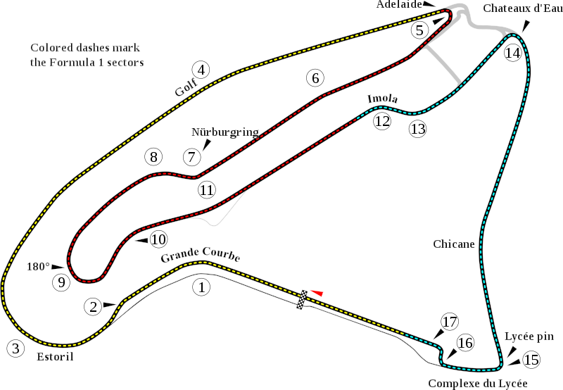
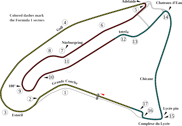
English: Track map of w:Circuit de Nevers Magny-Cours. |
| Datums | |
| Avots | Paša darbs |
| Autors | Will Pittenger |
| Citas versijas |
|

| Camera location | | View this and other nearby images on: OpenStreetMap |
|---|
Licence
| I, the copyright holder of this work, release this work into the public domain. This applies worldwide. In some countries this may not be legally possible; if so: I grant anyone the right to use this work for any purpose, without any conditions, unless such conditions are required by law. |
Faila hronoloģija
Uzklikšķini uz datums/laiks kolonnā esošās saites, lai apskatītos, kā šis fails izskatījās tad.
| Datums/Laiks | Attēls | Izmēri | Dalībnieks | Komentārs | |
|---|---|---|---|---|---|
| tagadējais | 2008. gada 13. jūlijs, plkst. 08.09 | | 1 356 × 939 (91 KB) | Will Pittenger | New version gets around the text on path bug in Mediawiki by turning such text into objects. To edit the text, please use the previous version. |
| 2008. gada 13. jūlijs, plkst. 08.06 |  | 1 356 × 939 (67 KB) | Will Pittenger | {{Information |Description={{en|1=Track map of w:Circuit de Nevers Magny-Cours.}} |Source=Own work by uploader |Author=Will Pittenger |Date=7-13-2008 |Permission= |other_versions=<gallery>Image:Circuit de Nevers Magny-Cours.png |
Faila lietojums
Šo failu izmanto šajās 4 lapās:
Globālais faila lietojums
Šīs Vikipēdijas izmanto šo failu:
- Izmantojums af.wikipedia.org
- Izmantojums ar.wikipedia.org
- Izmantojums ast.wikipedia.org
- Izmantojums bg.wikipedia.org
- Izmantojums bn.wikipedia.org
- Izmantojums br.wikipedia.org
- Izmantojums ca.wikipedia.org
- Izmantojums cs.wikipedia.org
- Izmantojums de.wikipedia.org
Skatīt šī faila pilno globālo izmantojumu.