Attēls:VietnameseProvincesMap.png
Sākotnējais fails (428 × 713 pikseļi, faila izmērs: 29 KB, MIME tips: image/png)
| Šis fails ir no Vikikrātuves. Tā apraksts no attēla lapas Vikikrātuvē ir parādīts zemāk. Vikikrātuve ir brīvi licencēta failu krātuve. Tu vari tai palīdzēt. |

|
This locator map image could be re-created using vector graphics as an SVG file. This has several advantages; see Commons:Media for cleanup for more information. If an SVG form of this image is available, please upload it and afterwards replace this template with
{{vector version available|new image name}}.
It is recommended to name the SVG file “VietnameseProvincesMap.svg”—then the template Vector version available (or Vva) does not need the new image name parameter. |
Original at: w:Image:VietnameseProvincesMap.png, where it says:
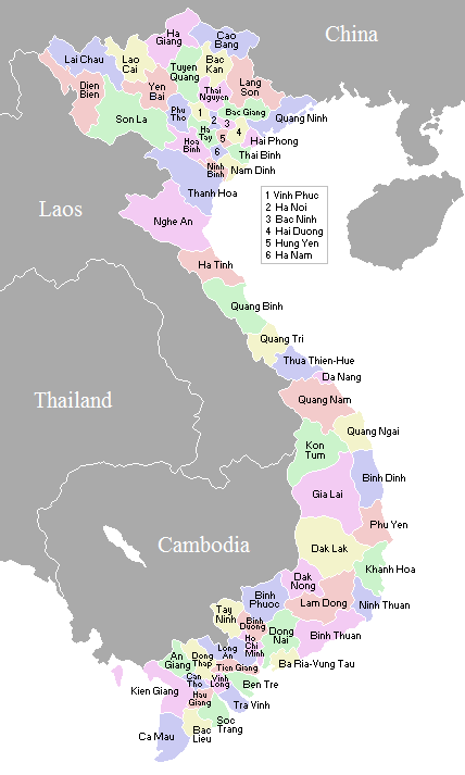
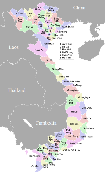
A map showing the borders and names of the Vietnamese provinces (including the changes approved in Nov 2003)
This country locator map was created by Vardion and is released into the public domain.
So this map is up to date as per current situation Waerth 07:19, 17 Mar 2005 (UTC)
See vi:Image:VietnameseProvincesMapTiengViet.png for the same map with the correctly accented Vietnamese names.
| I, the copyright holder of this work, release this work into the public domain. This applies worldwide. In some countries this may not be legally possible; if so: I grant anyone the right to use this work for any purpose, without any conditions, unless such conditions are required by law. |
en:Image:VietnameseProvincesMap.png
Faila hronoloģija
Uzklikšķini uz datums/laiks kolonnā esošās saites, lai apskatītos, kā šis fails izskatījās tad.
| Datums/Laiks | Attēls | Izmēri | Dalībnieks | Komentārs | |
|---|---|---|---|---|---|
| tagadējais | 2007. gada 2. novembris, plkst. 05.56 | | 428 × 713 (29 KB) | Vietlong | Reverted to version as of 11:41, 30 August 2006 |
| 2006. gada 30. augusts, plkst. 14.47 |  | 428 × 713 (25 KB) | Vietlong | Reverted to earlier revision | |
| 2006. gada 30. augusts, plkst. 14.41 |  | 428 × 713 (29 KB) | Vietlong | Correcting the boundary between Lai Chau and Lao Cai provinces | |
| 2006. gada 21. janvāris, plkst. 00.58 |  | 428 × 713 (25 KB) | Vardion | correcting boundary between Dien Bien and Lai Chau provinces | |
| 2005. gada 18. aprīlis, plkst. 08.55 |  | 428 × 713 (25 KB) | Vardion | fixing error | |
| 2005. gada 17. marts, plkst. 10.17 |  | 428 × 713 (25 KB) | Waerth | {{PD}} |
Faila lietojums
Šo failu izmanto šajā 1 lapā:
Globālais faila lietojums
Šīs Vikipēdijas izmanto šo failu:
- Izmantojums ace.wikipedia.org
- Izmantojums ar.wikipedia.org
- Izmantojums ba.wikipedia.org
- Izmantojums bg.wiktionary.org
- Izmantojums blk.wikipedia.org
- Izmantojums bn.wikipedia.org
- Izmantojums ca.wikipedia.org
- Izmantojums ce.wikipedia.org
- Izmantojums da.wikipedia.org
- Izmantojums en.wikipedia.org
- Izmantojums fi.wikipedia.org
- Izmantojums gl.wikipedia.org
- Izmantojums id.wikipedia.org
- Izmantojums it.wikipedia.org
- Izmantojums kk.wikipedia.org
- Izmantojums krc.wikipedia.org
- Izmantojums kv.wikipedia.org
- Izmantojums lt.wikipedia.org
- Izmantojums map-bms.wikipedia.org
- Izmantojums ms.wikipedia.org
- Izmantojums my.wikipedia.org
- Izmantojums nl.wikipedia.org
- Izmantojums no.wikipedia.org
- Izmantojums os.wikipedia.org
- Izmantojums pam.wikipedia.org
- Izmantojums pl.wikipedia.org
- Izmantojums pt.wikipedia.org
- Izmantojums roa-tara.wikipedia.org
- Izmantojums ru.wikipedia.org
- Izmantojums su.wikipedia.org
- Izmantojums sv.wikipedia.org
- Izmantojums tr.wikipedia.org
Skatīt šī faila pilno globālo izmantojumu.