Attēls:Ukraine under russian occupation grey.svg

Size of this PNG preview of this SVG file: 800 × 538 pikseļi. Citi izmēri: 320 × 215 pikseļi | 640 × 430 pikseļi | 1 024 × 688 pikseļi | 1 280 × 860 pikseļi | 2 560 × 1 720 pikseļi | 3 780 × 2 540 pikseļi.
Sākotnējais fails (SVG fails, definētais izmērs 3 780 × 2 540 pikseļi, faila izmērs: 1,8 MB)
| Šis fails ir no Vikikrātuves. Tā apraksts no attēla lapas Vikikrātuvē ir parādīts zemāk. Vikikrātuve ir brīvi licencēta failu krātuve. Tu vari tai palīdzēt. |
Kopsavilkums
| Apraksts |
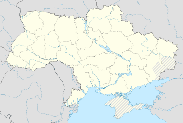
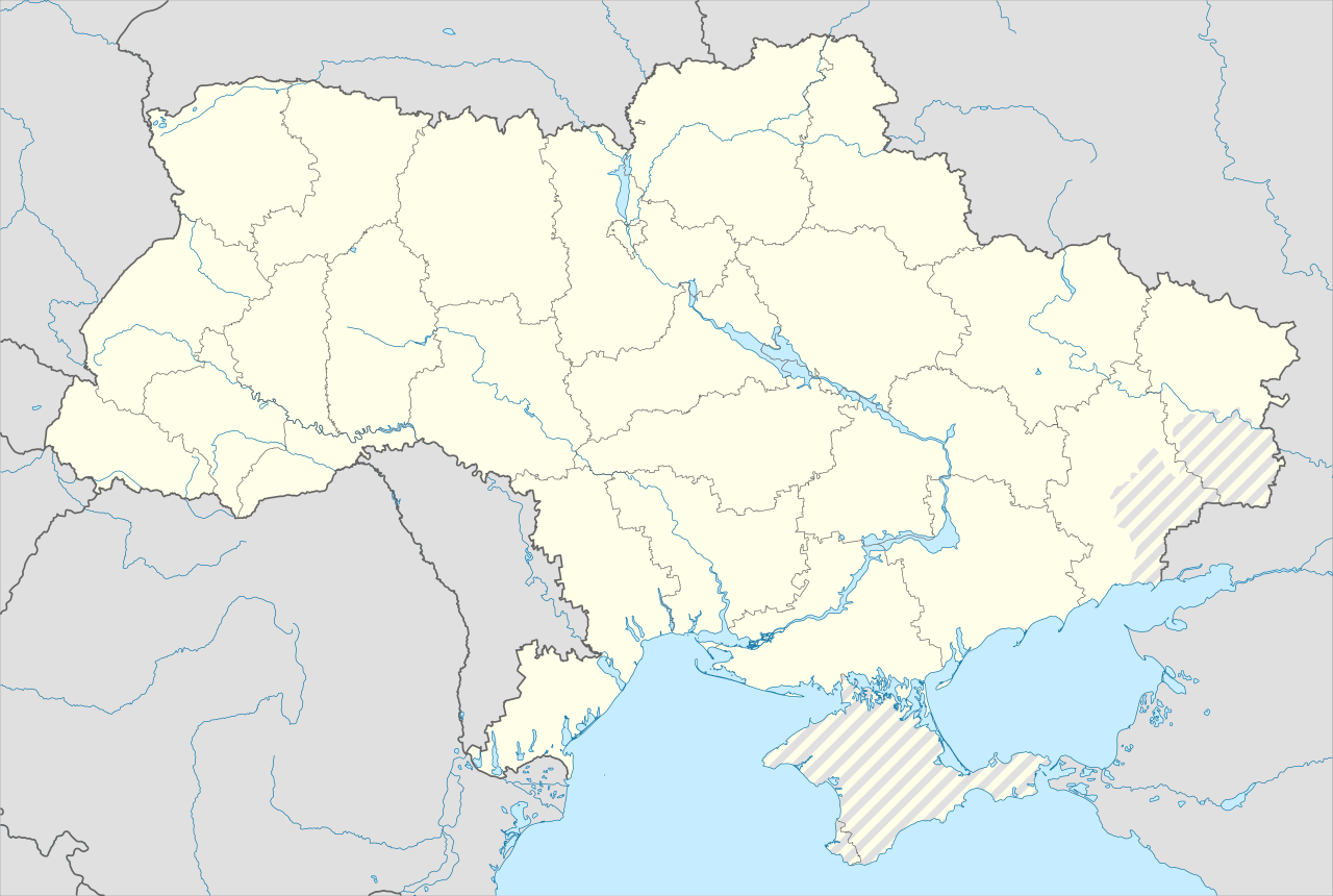
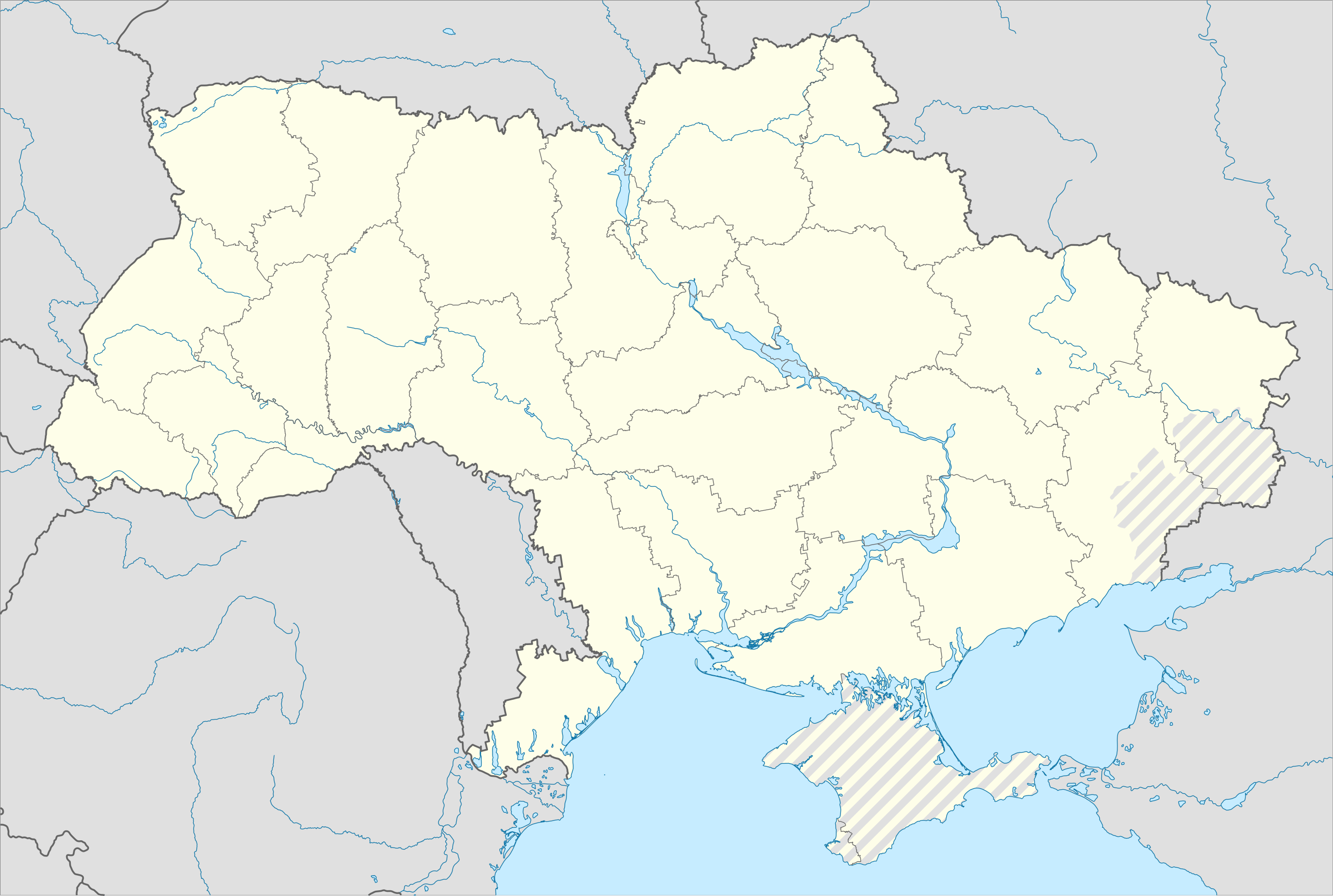
English: Location map of Ukraine under Russian occupation.
Українська: Карта України з зонами російської окупації. |
| Datums | |
| Avots |
Own work using: Ukraine adm location map improved.svg, according to
|
| Autors | Yakiv Gluck |
| Citas versijas |
|
| SVG veidošana | This map was created with Adobe Illustrator. |


Licence
Es, šī darba autortiesību īpašnieks, publicēju to saskaņā ar šo licenci:
This file is licensed under the Creative Commons Attribution-Share Alike 4.0 International license.
- Jūs varat brīvi:
- koplietot – kopēt, izplatīt un pārraidīt darbu
- remiksēt – pielāgot darbu
- Saskaņā ar šādiem nosacījumiem:
- atsaucoties – Tev ir jānorāda autors, saite uz licenci un to, vai veiktas kādas izmaiņas. To var darīt jebkādā saprātīgā veidā, bet ne tādā, kas norādītu, ka licencētājs atbalsta tevi vai veidu, kā tu izmanto šo darbu.
- nemainot licenci – Ja tu miksē, pārveido vai izmanto materiālu, tev savs devums jāpublicē ar to pašu vai saderīgu licenci kā oriģināls.
Faila hronoloģija
Uzklikšķini uz datums/laiks kolonnā esošās saites, lai apskatītos, kā šis fails izskatījās tad.
| Datums/Laiks | Attēls | Izmēri | Dalībnieks | Komentārs | |
|---|---|---|---|---|---|
| tagadējais | 2023. gada 19. jūnijs, plkst. 09.53 | | 3 780 × 2 540 (1,8 MB) | Physeters | Reverted to version as of 02:11, 12 May 2023 (UTC) revert removed my detail improvements in the Dnieper delta and is no longer accurate |
| 2023. gada 19. jūnijs, plkst. 00.48 |  | 3 780 × 2 540 (1,54 MB) | Yeagvr | Reverted to version as of 17:23, 3 October 2022 (UTC) | |
| 2023. gada 12. maijs, plkst. 05.11 |  | 3 780 × 2 540 (1,8 MB) | Physeters | add improved tracing of the Dnieper Delta | |
| 2022. gada 4. oktobris, plkst. 04.30 |  | 3 780 × 2 540 (1,36 MB) | Tol | Reverted to version as of 17:17, 3 March 2018 (UTC): this substantially changes a file that was not expected to be updated, this file is intentionally different from File:Ukraine under russian occupation.svg | |
| 2022. gada 3. oktobris, plkst. 20.23 |  | 3 780 × 2 540 (1,54 MB) | Janitoalevic | Updated. | |
| 2018. gada 3. marts, plkst. 20.17 |  | 3 780 × 2 540 (1,36 MB) | Yakiv Gluck | improved using new adm loc map | |
| 2018. gada 27. janvāris, plkst. 04.36 |  | 1 546 × 1 038 (457 KB) | Yakiv Gluck | {{Information |Description ={{en|Location map of Ukraine under russian occupation.}} {{uk|Карта України з зонами російської окупації.}} |Source =own work, using [[:F... |
Faila lietojums
Šo failu neizmanto nevienā lapā.
Globālais faila lietojums
Šīs Vikipēdijas izmanto šo failu:
- Izmantojums bcl.wikipedia.org
- Izmantojums bn.wikipedia.org
- Izmantojums en.wikipedia.org
- Chernobyl
- Geography of Ukraine
- Poltava
- Kerch
- Sevastopol
- Tarashcha
- Yalta
- Nestor Makhno
- Sverdlovsk, Ukraine
- Chernivtsi
- Kaniv
- Halych
- Pripyat
- Lutsk
- Drohobych
- Kovel
- Ivano-Frankivsk
- Kalush, Ukraine
- Volodymyr (city)
- Kortelisy
- Starobilsk
- Uzhhorod
- Chernihiv
- Sumy
- Staryi Ostropil
- Kyiv
- Kosivka, Odesa Oblast
- Kosiv
- Shpola
- Mukachevo
- Simferopol
- Irpin
- Khmelnytskyi
- Fastiv
- Boltysh crater
Skatīt šī faila pilno globālo izmantojumu.