Attēls:Tour de France 2015 map-fr.svg

Size of this PNG preview of this SVG file: 498 × 600 pikseļi. Citi izmēri: 199 × 240 pikseļi | 399 × 480 pikseļi | 638 × 768 pikseļi | 850 × 1 024 pikseļi | 1 701 × 2 048 pikseļi | 1 225 × 1 475 pikseļi.
Sākotnējais fails (SVG fails, definētais izmērs 1 225 × 1 475 pikseļi, faila izmērs: 1,85 MB)
| Šis fails ir no Vikikrātuves. Tā apraksts no attēla lapas Vikikrātuvē ir parādīts zemāk. Vikikrātuve ir brīvi licencēta failu krātuve. Tu vari tai palīdzēt. |
Kopsavilkums
| Apraksts |
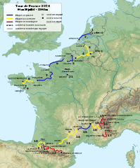
English: Roadmap of Tour de France 2015. Français : Carte du tracé du Tour de France 2015. |
||
| Datums | |||
| Avots |
|
||
| Autors | Sémhur (diskusija) | ||
| Citas versijas |
| ||
| Atsauce (required by the license) | © Sémhur / Wikimedia Commons / | ||
| SVG | W3C-validity not checked.
|
||
| Graphic Lab |

| Object location | | View this and other nearby images on: OpenStreetMap |
|---|
Licence
Es, šī darba autortiesību īpašnieks, publicēju to saskaņā ar šīm licencēm:
| Copyleft: This work of art is free; you can redistribute it and/or modify it according to terms of the Free Art License. You will find a specimen of this license on the Copyleft Attitude site as well as on other sites. |
This file is licensed under the Creative Commons Attribution-Share Alike 4.0 International, 3.0 Unported, 2.5 Generic, 2.0 Generic and 1.0 Generic license.
- Jūs varat brīvi:
- koplietot – kopēt, izplatīt un pārraidīt darbu
- remiksēt – pielāgot darbu
- Saskaņā ar šādiem nosacījumiem:
- atsaucoties – Tev ir jānorāda autors, saite uz licenci un to, vai veiktas kādas izmaiņas. To var darīt jebkādā saprātīgā veidā, bet ne tādā, kas norādītu, ka licencētājs atbalsta tevi vai veidu, kā tu izmanto šo darbu.
- nemainot licenci – Ja tu miksē, pārveido vai izmanto materiālu, tev savs devums jāpublicē ar to pašu vai saderīgu licenci kā oriģināls.
Jūs varat izvēlēties licenci pēc jūsu vēlmes.
Faila hronoloģija
Uzklikšķini uz datums/laiks kolonnā esošās saites, lai apskatītos, kā šis fails izskatījās tad.
| Datums/Laiks | Attēls | Izmēri | Dalībnieks | Komentārs | |
|---|---|---|---|---|---|
| tagadējais | 2015. gada 12. augusts, plkst. 21.33 | | 1 225 × 1 475 (1,85 MB) | Sémhur | L'étape 4 est en accidentée (et non plus plaine), l'étape 10 aussi en accidentée (et non montagne) et l’étape 13 encore en accidentée (et non en plaine). Cf. page 12 du règlement (http://www.letour.fr/le-tour/2015/docs/TDF15_Reglement-BD.pdf) |
| 2015. gada 19. jūlijs, plkst. 12.55 |  | 1 225 × 1 475 (1,85 MB) | Sémhur | 17 => 20 | |
| 2015. gada 8. aprīlis, plkst. 23.53 |  | 1 225 × 1 475 (1,85 MB) | Sémhur | == {{int:filedesc}} == {{Information |Description={{Multilingual description |en= Roadmap of Tour de France 2015. |fr= Carte du tracé du Tour de France 2015. }} |Source= * [[:File:Fond de carte T... |
Faila lietojums
Šo failu neizmanto nevienā lapā.
Globālais faila lietojums
Šīs Vikipēdijas izmanto šo failu:
- Izmantojums cy.wikipedia.org
- Izmantojums de.wikipedia.org
- Izmantojums fi.wikipedia.org
- Izmantojums fr.wikipedia.org
- Izmantojums hr.wikipedia.org
- Izmantojums ie.wikipedia.org
- Izmantojums it.wikipedia.org
- Izmantojums ja.wikipedia.org
- Izmantojums nl.wikipedia.org
- Izmantojums sv.wikipedia.org