Attēls:Slavo serbia map.png

Šī priekšskata izmērs: 800 × 560 pikseļi. Citi izmēri: 320 × 224 pikseļi | 640 × 448 pikseļi | 1 024 × 717 pikseļi | 1 274 × 892 pikseļi.
Sākotnējais fails (1 274 × 892 pikseļi, faila izmērs: 66 KB, MIME tips: image/png)
| Šis fails ir no Vikikrātuves. Tā apraksts no attēla lapas Vikikrātuvē ir parādīts zemāk. Vikikrātuve ir brīvi licencēta failu krātuve. Tu vari tai palīdzēt. |
Kopsavilkums
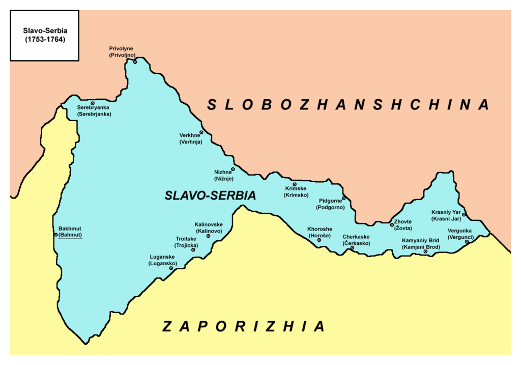
- English: Map of Slavo-Serbia, a territory of Imperial Russia from 1753 to 1764.
- Serbian: Mapa Slavenosrbije, teritorije Ruskog carstva, između 1753. i 1764. godine.
Source and licence
Self-made map by PANONIAN
| This work has been released into the public domain by its author, PANONIAN. This applies worldwide. In some countries this may not be legally possible; if so: |
References
- Mita Kostić, Nova Srbija i Slavenosrbija, Novi Sad, 2001.
- Olga M. Posunjko, Istorija Nove Srbije i Slavenosrbije, Novi Sad, 2002.
- Pavel Rudjakov, Seoba Srba u Rusiju u 18. veku, Beograd, 1995.
- http://www.rastko.rs/rastko-ukr/istorija/img/sloveno_serbija.jpg
- http://www.irekw.internetdsl.pl/27_1727-1768.jpg
- http://www.jewishgen.org/Ukraine/maps/Ukrainian-Land-1750.jpg
Place names
| Serbian name from the middle of the 18th century | Ukrainian/Russian name from the middle of the 18th century (1.) | Newer or modern Ukrainian/Russian name (1.) |
|---|---|---|
| Bahmut | Bakhmut | Artemivsk |
| Serebrjanka | Serebryanka | Serebryanka |
| Privoljno | Privolyne | Privillya |
| Verhnja | Verkhne | - |
| Nižnje | Nizhne | Nizhne |
| Lugansko | Luganske | Luganske |
| Trojicka | Troitske | Troitske |
| Kalinovo | Kalinovske | Kalinove |
| Krimsko | Krimske | Krimske |
| Podgorno | Pidgorne | Slovianoserbsk / Slovyanoserbsk |
| Horoše | Khoroshe | Khoroshe |
| Čerkasko | Cherkaske | Cherkaski Brod / Zimogirya |
| Žovta | Zhovte | Zhovte |
| Krasni Jar | Krasniy Yar | - |
| Kamjani Brod | Kamyaniy Brid | Kamyany Brid |
| Vergunci | Vergunka | Vergunka |
Notes:
- (1.) Ukrainian and Russian names are given in Latin script transliterations.
Faila hronoloģija
Uzklikšķini uz datums/laiks kolonnā esošās saites, lai apskatītos, kā šis fails izskatījās tad.
| Datums/Laiks | Attēls | Izmēri | Dalībnieks | Komentārs | |
|---|---|---|---|---|---|
| tagadējais | 2013. gada 1. oktobris, plkst. 12.55 | | 1 274 × 892 (66 KB) | PANONIAN | aesthetics |
| 2010. gada 2. maijs, plkst. 17.45 |  | 1 279 × 894 (66 KB) | PANONIAN | names corrections | |
| 2010. gada 1. maijs, plkst. 23.37 |  | 1 279 × 894 (65 KB) | PANONIAN | name correction | |
| 2010. gada 26. aprīlis, plkst. 17.40 |  | 1 279 × 894 (65 KB) | PANONIAN | improved version | |
| 2009. gada 19. marts, plkst. 04.50 |  | 930 × 596 (36 KB) | PANONIAN | Map of Slavo-Serbia, a territory of Imperial Russia from 1753 to 1764. Self-made map by PANONIAN {{PD-user|PANONIAN}} Category:Maps of the history of Serbia Category:Maps of the history of Ukraine [[Category:Maps of the history |
Faila lietojums
Šo failu izmanto šajā 1 lapā:
Globālais faila lietojums
Šīs Vikipēdijas izmanto šo failu:
- Izmantojums de.wikipedia.org
- Izmantojums en.wikipedia.org
- Izmantojums es.wikipedia.org
- Izmantojums fr.wikipedia.org
- Izmantojums it.wikipedia.org
- Izmantojums nl.wikipedia.org
- Izmantojums pl.wikipedia.org
- Izmantojums ru.wikipedia.org
- Izmantojums sh.wikipedia.org
- Izmantojums uk.wikipedia.org
- Izmantojums vi.wikipedia.org