Attēls:Salmon River.JPG

Šī priekšskata izmērs: 800 × 600 pikseļi. Citi izmēri: 320 × 240 pikseļi | 640 × 480 pikseļi | 1 024 × 768 pikseļi | 1 280 × 960 pikseļi | 2 560 × 1 920 pikseļi | 2 816 × 2 112 pikseļi.
Sākotnējais fails (2 816 × 2 112 pikseļi, faila izmērs: 2,5 MB, MIME tips: image/jpeg)
| Šis fails ir no Vikikrātuves. Tā apraksts no attēla lapas Vikikrātuvē ir parādīts zemāk. Vikikrātuve ir brīvi licencēta failu krātuve. Tu vari tai palīdzēt. |
Kopsavilkums
| Apraksts |
Brezhoneg: Ar Salmon River a zo adstêr vrasañ ar Snake River. Lec'hiet e vez er Salmon River Mountains.
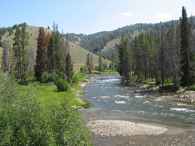
English: The Salmon River is the largest tributary of the Snake River. Salmon River in Sawtooth National Recreation Area.
Español: El río Salmon en la « Sawtooth National Recreation Area».
Français : La Salmon River est le plus important affluent de la Snake River. Il coule dans les Salmon River Mountains. Salmon River dans la Sawtooth NRA. |
| Datums | |
| Avots | Paša darbs |
| Autors | Fredlyfish4 |
| Camera location | | View this and other nearby images on: OpenStreetMap |
|---|
Licence
Es, šī darba autortiesību īpašnieks, publicēju to saskaņā ar šo licenci:
This file is licensed under the Creative Commons Attribution-Share Alike 4.0 International license.
- Jūs varat brīvi:
- koplietot – kopēt, izplatīt un pārraidīt darbu
- remiksēt – pielāgot darbu
- Saskaņā ar šādiem nosacījumiem:
- atsaucoties – Tev ir jānorāda autors, saite uz licenci un to, vai veiktas kādas izmaiņas. To var darīt jebkādā saprātīgā veidā, bet ne tādā, kas norādītu, ka licencētājs atbalsta tevi vai veidu, kā tu izmanto šo darbu.
- nemainot licenci – Ja tu miksē, pārveido vai izmanto materiālu, tev savs devums jāpublicē ar to pašu vai saderīgu licenci kā oriģināls.
| File created by Fredlyfish4 | |
| Permission is granted for use under CC BY-SA 4.0 (or a similar license) for this file created by the author.
Please let the author know if you use this work outside of Wikimedia projects by sending an email to
|
Original upload log
The original description page was here. All following user names refer to en.wikipedia.
- 2008-10-26 19:35 Fredlyfish4 2816×2112× (2622143 bytes) {{GFDL-self}}
This image has been assessed using the Quality image guidelines and is considered a Quality image.
|
Faila hronoloģija
Uzklikšķini uz datums/laiks kolonnā esošās saites, lai apskatītos, kā šis fails izskatījās tad.
| Datums/Laiks | Attēls | Izmēri | Dalībnieks | Komentārs | |
|---|---|---|---|---|---|
| tagadējais | 2009. gada 10. februāris, plkst. 22.37 | | 2 816 × 2 112 (2,5 MB) | Urdangaray | {{Information |Description={{en|''no original description''}} |Source=Transferred from [http://en.wikipedia.org en.wikipedia] |Date=2008-10-26 (original upload date) |Author=Original uploader was Fredlyfish4 at [http://en.wikipedi |
Faila lietojums
Šo failu izmanto šajā 1 lapā:
Globālais faila lietojums
Šīs Vikipēdijas izmanto šo failu:
- Izmantojums br.wikipedia.org
- Izmantojums da.wikipedia.org
- Izmantojums en.wikipedia.org
- Izmantojums es.wikipedia.org
- Izmantojums fi.wikipedia.org
- Izmantojums fr.wikipedia.org
- Izmantojums he.wikipedia.org
- Izmantojums hy.wikipedia.org
- Izmantojums it.wikipedia.org
- Izmantojums lt.wikipedia.org
- Izmantojums ru.wikipedia.org
- Izmantojums sr.wikipedia.org
- Izmantojums sv.wikipedia.org
- Izmantojums uk.wikipedia.org