Attēls:Russian Occupation of Kherson Oblast.svg

Sākotnējais fails (SVG fails, definētais izmērs 1 430 × 1 048 pikseļi, faila izmērs: 649 KB)
| Šis fails ir no Vikikrātuves. Tā apraksts no attēla lapas Vikikrātuvē ir parādīts zemāk. Vikikrātuve ir brīvi licencēta failu krātuve. Tu vari tai palīdzēt. |
Kopsavilkums

|
This file may be updated to reflect new information. If you wish to use a specific version of the file without new updates being mirrored, please upload the required version as a separate file. |
| Apraksts |
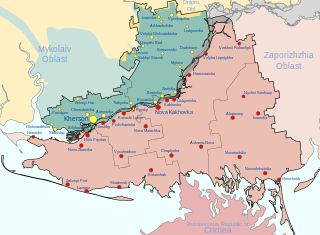
Русский: Заявленная ( , — деоккупированная) территория Херсонской военно-гражданской администрации, совпадающая с территорией Херсонской области Украины, и контролируемая ХВГА территория ( )
English: Claimed ( , — deoccupied) territory of Russia's Khersonskaya Oblast (not including the environs of Snihurivka), coinciding with the territory of Kherson Oblast in Ukraine, and dependent territory of Khersonskaya Oblast ( )
Français : territoire revendiqué ( , — déoccupé) de l'administration militaro-civile de Kherson, coïncidant avec le territoire de la région de Kherson en Ukraine, et territoire dépendant du AMCK ( ) |
| Datums | 2022. gada 27. augusts (first version) |
| Avots |
Paša darbs, derivate of 2022 Russian invasion of Ukraine.svg by Viewsridge, Kherson in Ukraine (claims hatched).svg by TUBS, & Kherson military–civilian administration.png by Тыченко
|
| Autors | Physeters |
| Citas versijas |
[]
|


.png)


.png)


.svg)
This file is translated using SVG <switch> elements. All translations are stored in the same file! Learn more.
For most Wikipedia projects, you can embed the file normally (without a To translate the text into your language, you can use the SVG Translate tool. Alternatively, you can download the file to your computer, add your translations using whatever software you're familiar with, and re-upload it with the same name. You will find help in Graphics Lab if you're not sure how to do this. |
Licence
- Jūs varat brīvi:
- koplietot – kopēt, izplatīt un pārraidīt darbu
- remiksēt – pielāgot darbu
- Saskaņā ar šādiem nosacījumiem:
- atsaucoties – Tev ir jānorāda autors, saite uz licenci un to, vai veiktas kādas izmaiņas. To var darīt jebkādā saprātīgā veidā, bet ne tādā, kas norādītu, ka licencētājs atbalsta tevi vai veidu, kā tu izmanto šo darbu.
- nemainot licenci – Ja tu miksē, pārveido vai izmanto materiālu, tev savs devums jāpublicē ar to pašu vai saderīgu licenci kā oriģināls.
Faila hronoloģija
Uzklikšķini uz datums/laiks kolonnā esošās saites, lai apskatītos, kā šis fails izskatījās tad.
| Datums/Laiks | Attēls | Izmēri | Dalībnieks | Komentārs | |
|---|---|---|---|---|---|
| tagadējais | 2024. gada 16. janvāris, plkst. 11.44 | | 1 430 × 1 048 (649 KB) | Physeters | remove Kakhovka Reservoir |
| 2024. gada 16. janvāris, plkst. 01.19 |  | 1 430 × 1 048 (477 KB) | Physeters | Updates per the ISW, add Bilohrudove, Pishchanivka, Kozachi Laheri and Krynky | |
| 2023. gada 31. augusts, plkst. 08.57 |  | 1 430 × 1 048 (464 KB) | Physeters | the flooding completely subsided months ago | |
| 2023. gada 2. jūlijs, plkst. 00.17 |  | 1 430 × 1 048 (486 KB) | Semyon 'dicto' Fedotov | fixed typo, removed unnecessary accents | |
| 2023. gada 16. jūnijs, plkst. 09.52 |  | 1 430 × 1 048 (486 KB) | Physeters | update flooding and control of Oleshky per the ISW | |
| 2023. gada 9. jūnijs, plkst. 00.13 |  | 1 430 × 1 048 (478 KB) | Physeters | Clean up flooded areas; make flooded areas grey, since they are most likely controlled by neither side at this time | |
| 2023. gada 8. jūnijs, plkst. 21.52 |  | 1 430 × 1 048 (469 KB) | Nahabino | Update. | |
| 2023. gada 8. jūnijs, plkst. 14.58 |  | 1 430 × 1 048 (470 KB) | Nahabino | Update. | |
| 2023. gada 7. jūnijs, plkst. 17.07 |  | 1 430 × 1 048 (470 KB) | Nahabino | minor fixes | |
| 2023. gada 7. jūnijs, plkst. 17.03 |  | 1 430 × 1 048 (469 KB) | Nahabino | Update with possible water flow. |
Faila lietojums
Šo failu izmanto šajā 1 lapā:
Globālais faila lietojums
Šīs Vikipēdijas izmanto šo failu:
- Izmantojums ar.wikipedia.org
- Izmantojums be.wikipedia.org
- Izmantojums ca.wikipedia.org
- Izmantojums cs.wikipedia.org
- Izmantojums de.wikipedia.org
- Izmantojums en.wikipedia.org
- Izmantojums es.wikipedia.org
- Izmantojums et.wikipedia.org
- Izmantojums fr.wikipedia.org
- Izmantojums he.wikipedia.org
- Izmantojums hu.wikipedia.org
- Izmantojums id.wikipedia.org
- Izmantojums it.wikipedia.org
- Izmantojums ja.wikipedia.org
- Izmantojums lmo.wikipedia.org
- Izmantojums pl.wikipedia.org
- Izmantojums pt.wikipedia.org
- Izmantojums ru.wikipedia.org
- Izmantojums uk.wikipedia.org
- Izmantojums www.wikidata.org
- Izmantojums zh.wikipedia.org