Attēls:Routes of the Spanish Armada.gif

Šī priekšskata izmērs: 329 × 599 pikseļi. Citi izmēri: 132 × 240 pikseļi | 415 × 756 pikseļi.
Sākotnējais fails (415 × 756 pikseļi, faila izmērs: 27 KB, MIME tips: image/gif)
| Šis fails ir no Vikikrātuves. Tā apraksts no attēla lapas Vikikrātuvē ir parādīts zemāk. Vikikrātuve ir brīvi licencēta failu krātuve. Tu vari tai palīdzēt. |
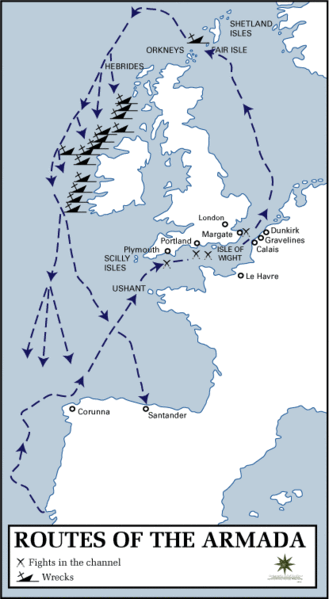
Kopsavilkums
Map of the route taken by the Spanish Armada.
Source: History Department of the United States Military Academy at West Point
Other version: Classical Chinese translation, German translation, Spanish translation, French translation
.svg)
derivative works
Derivative works of this file: Routes of the Spanish Armada-es.svg
Licence
This work is in the public domain in the United States because it is a work prepared by an officer or employee of the United States Government as part of that person’s official duties under the terms of Title 17, Chapter 1, Section 105 of the US Code.
Note: This only applies to original works of the Federal Government and not to the work of any individual U.S. state, territory, commonwealth, county, municipality, or any other subdivision. This template also does not apply to postage stamp designs published by the United States Postal Service since 1978. (See § 313.6(C)(1) of Compendium of U.S. Copyright Office Practices). It also does not apply to certain US coins; see The US Mint Terms of Use.
|
 | |
| This file has been identified as being free of known restrictions under copyright law, including all related and neighboring rights. | ||
Faila hronoloģija
Uzklikšķini uz datums/laiks kolonnā esošās saites, lai apskatītos, kā šis fails izskatījās tad.
| Datums/Laiks | Attēls | Izmēri | Dalībnieks | Komentārs | |
|---|---|---|---|---|---|
| tagadējais | 2006. gada 18. janvāris, plkst. 17.23 | | 415 × 756 (27 KB) | Kooma | ==Summary== Map of the route taken by the Spanish Armada. Source: [http://www.dean.usma.edu/history/atlases/dawn_modern_warfare/routes_armada.html History Department of the United States Military Academy at West Point] ==Licensing== {{PD-USGov}} [[ |
Faila lietojums
Šo failu izmanto šajā 1 lapā:
Globālais faila lietojums
Šīs Vikipēdijas izmanto šo failu:
- Izmantojums af.wikipedia.org
- Izmantojums azb.wikipedia.org
- Izmantojums az.wikipedia.org
- Izmantojums be.wikipedia.org
- Izmantojums da.wikipedia.org
- Izmantojums da.wikibooks.org
- Izmantojums el.wikipedia.org
- Izmantojums en.wikipedia.org
- Izmantojums et.wikipedia.org
- Izmantojums fa.wikipedia.org
- Izmantojums fi.wikipedia.org
- Izmantojums fr.wikipedia.org
- Izmantojums ga.wikipedia.org
- Izmantojums hu.wikipedia.org
- Izmantojums hy.wikipedia.org
- Izmantojums it.wikipedia.org
- Izmantojums ja.wikipedia.org
- Izmantojums ka.wikipedia.org
- Izmantojums nl.wikipedia.org
- Izmantojums no.wikipedia.org
- Izmantojums pl.wikipedia.org
- Izmantojums pt.wikipedia.org
- Izmantojums ro.wikipedia.org
- Izmantojums simple.wikipedia.org
- Izmantojums sv.wikipedia.org
- Izmantojums ta.wikipedia.org
- Izmantojums uk.wikipedia.org
- Izmantojums www.wikidata.org