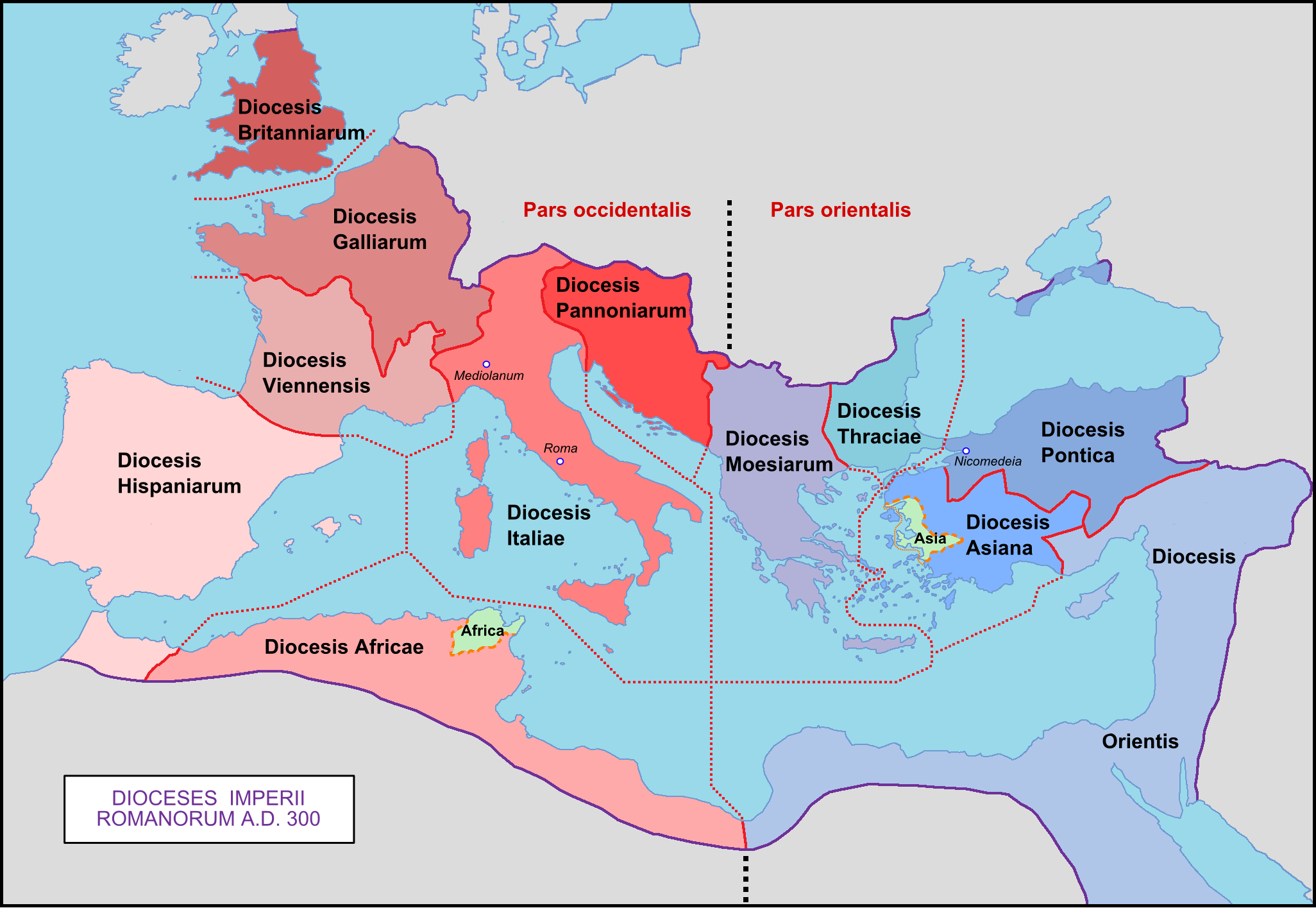
Attēls:Roman Empire with dioceses in 300 AD.png
Šī priekšskata izmērs: 800 × 552 pikseļi. Citi izmēri: 320 × 221 pikseļi | 640 × 441 pikseļi | 1 024 × 706 pikseļi | 1 280 × 883 pikseļi | 2 052 × 1 415 pikseļi.
Sākotnējais fails (2 052 × 1 415 pikseļi, faila izmērs: 213 KB, MIME tips: image/png)
| Šis fails ir no Vikikrātuves. Tā apraksts no attēla lapas Vikikrātuvē ir parādīts zemāk. Vikikrātuve ir brīvi licencēta failu krātuve. Tu vari tai palīdzēt. |

|
This map image could be re-created using vector graphics as an SVG file. This has several advantages; see Commons:Media for cleanup for more information. If an SVG form of this image is available, please upload it and afterwards replace this template with
{{vector version available|new image name}}.
It is recommended to name the SVG file “Roman Empire with dioceses in 300 AD.svg”—then the template Vector version available (or Vva) does not need the new image name parameter. |
Kopsavilkums
| Apraksts |
English: Map of the Roman Empire with dioceses created by Diocletien.
Français : Carte de l'Empire romain avec les diocèses créés par l'empereur Dioclétien. |
| Datums | 03/03/09 |
| Avots | Paša darbs |
| Autors | Mandrak |
| Citas versijas |
Derivative works of this file: Prima tetrarchia Diocletianus.PNG Blank map : File:Blank Roman Empire.png []
|


Licence
| I, the copyright holder of this work, release this work into the public domain. This applies worldwide. In some countries this may not be legally possible; if so: I grant anyone the right to use this work for any purpose, without any conditions, unless such conditions are required by law. |
Faila hronoloģija
Uzklikšķini uz datums/laiks kolonnā esošās saites, lai apskatītos, kā šis fails izskatījās tad.
| Datums/Laiks | Attēls | Izmēri | Dalībnieks | Komentārs | |
|---|---|---|---|---|---|
| tagadējais | 2020. gada 8. aprīlis, plkst. 03.29 | | 2 052 × 1 415 (213 KB) | Wikisaurus | without bottom part, because it was wrong to rewrite a file used in many articles like this |
| 2019. gada 29. novembris, plkst. 15.26 |  | 2 052 × 2 830 (344 KB) | Claude Zygiel | Cosmetics, Chersonesos, details according with http://www.tuttitemi.altervista.org/Storia/StoriaA/DioclezianoRomolo.htm | |
| 2019. gada 22. novembris, plkst. 18.54 |  | 2 052 × 2 830 (307 KB) | Claude Zygiel | Add below praefecturae year 395 according with Megistias's map [https://commons.wikimedia.org/wiki/File:Praetorian_Prefectures_of_the_Roman_Empire_395_AD.png] | |
| 2009. gada 10. marts, plkst. 15.34 |  | 2 052 × 1 414 (218 KB) | Mandrak | Erreurs corrigées. | |
| 2009. gada 3. marts, plkst. 23.03 |  | 2 052 × 1 414 (218 KB) | Mandrak | {{Information |Description={{en|1=Map of the Roman Empire with dioceses created by Diocletien.}} {{fr|1=Carte de l'Empire romain avec les diocèses créés par l'empereur Dioclétien.}} |Source=travail personnel (own work) |Author=Mandrak |
Faila lietojums
Šo failu neizmanto nevienā lapā.
Globālais faila lietojums
Šīs Vikipēdijas izmanto šo failu:
- Izmantojums ar.wikipedia.org
- Izmantojums ast.wikipedia.org
- Izmantojums az.wikipedia.org
- Izmantojums be.wikipedia.org
- Izmantojums bg.wikipedia.org
- Izmantojums ca.wikipedia.org
- Izmantojums cs.wikipedia.org
- Izmantojums de.wikipedia.org
- 300
- Konstantin der Große
- Moesia inferior
- Dioecesis Orientis
- Dioecesis Pontica
- Dioecesis Asiana
- Dioecesis Thraciarum
- Dioecesis Moesiae
- Dioecesis Pannoniae
- Vorlage:Navigationsleiste Diözesen des Römischen Reiches
- Dioecesis Africae
- Dioecesis Britanniae
- Dioecesis Galliae
- Dioecesis Septem Provinciarum
- Dioecesis Aegypti
- Dioecesis Hispaniae
- Dioecesis Italiae
- Dioecesis Italiae Annonariae
- Dioecesis Italiae Suburbicariae
- Dioecesis Daciae
- Dioecesis Macedoniae
- Römisches Italien
- Izmantojums el.wikipedia.org
- Izmantojums en.wikipedia.org
Skatīt šī faila pilno globālo izmantojumu.