Attēls:River volkhov localization map.jpg
Šī priekšskata izmērs: 800 × 551 pikseļi. Citi izmēri: 320 × 220 pikseļi | 640 × 440 pikseļi | 866 × 596 pikseļi.
Sākotnējais fails (866 × 596 pikseļi, faila izmērs: 342 KB, MIME tips: image/jpeg)
| Šis fails ir no Vikikrātuves. Tā apraksts no attēla lapas Vikikrātuvē ir parādīts zemāk. Vikikrātuve ir brīvi licencēta failu krātuve. Tu vari tai palīdzēt. |
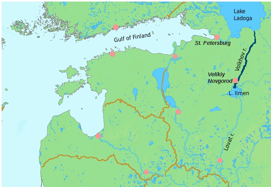
| Apraksts | Localization map for the Volkhov river (deep blue). |
| Datums | (UTC) |
| Avots | |
| Autors |
|
| Citas versijas | Derivative works of this file: Gulf of RigaIT.png |
| This is a retouched picture, which means that it has been digitally altered from its original version. Modifications: Cleared numbers, added labels, highlighted Volkhov r.. The original can be viewed here: LA2-Rivers of western Russia.png:
|
Es, šī darba autortiesību īpašnieks, publicēju to saskaņā ar šo licenci:
This image is in the public domain because it came from the site https://www.demis.nl/products/web-map-server/examples/ and was released by the copyright holder. Permission is granted to copy, distribute and/or modify this map since it is based on free of copyright images from: www.demis.nl. See also approval email on de.wp and its clarification.
|
| This work has been released into the public domain by its copyright holder, www.demis.nl. This applies worldwide. In some countries this may not be legally possible; if so: www.demis.nl grants anyone the right to use this work for any purpose, without any conditions, unless such conditions are required by law.
|
Original upload log
This image is a derivative work of the following images:
- File:LA2-Rivers_of_western_Russia.png licensed with PD-Demis
- 2008-05-20T22:30:46Z LA2 1274x1178 (269354 Bytes) {{Information |Description=Map of western Russia, with national borders marked (brown), rivers emphasized (dark blue) and major cities (pink) numbered (black). Bounding box West 19°, South 50°, East 40°, North 61°. Center
Uploaded with derivativeFX
Faila hronoloģija
Uzklikšķini uz datums/laiks kolonnā esošās saites, lai apskatītos, kā šis fails izskatījās tad.
| Datums/Laiks | Attēls | Izmēri | Dalībnieks | Komentārs | |
|---|---|---|---|---|---|
| tagadējais | 2010. gada 13. marts, plkst. 20.06 | | 866 × 596 (342 KB) | Alþykkr | {{Information |Description=Localization map for the Volkhov river (deep blue). |Source=*File:LA2-Rivers_of_western_Russia.png |Date=2010-03-13 17:01 (UTC) |Author=*File:LA2-Rivers_of_western_Russia.png: LA2 *derivative work: ~~~ | |
Faila lietojums
Šo failu izmanto šajā 1 lapā:
Globālais faila lietojums
Šīs Vikipēdijas izmanto šo failu:
- Izmantojums azb.wikipedia.org
- Izmantojums cs.wikipedia.org
- Izmantojums fa.wikipedia.org
- Izmantojums fr.wikipedia.org
- Izmantojums hy.wikipedia.org
- Izmantojums ja.wikipedia.org
- Izmantojums pt.wikipedia.org
- Izmantojums sv.wikipedia.org
- Izmantojums uz.wikipedia.org