Attēls:Pyrenees topographic map-en.svg

Size of this PNG preview of this SVG file: 800 × 475 pikseļi. Citi izmēri: 320 × 190 pikseļi | 640 × 380 pikseļi | 1 024 × 608 pikseļi | 1 280 × 760 pikseļi | 2 560 × 1 520 pikseļi | 3 200 × 1 900 pikseļi.
Sākotnējais fails (SVG fails, definētais izmērs 3 200 × 1 900 pikseļi, faila izmērs: 6,3 MB)
| Šis fails ir no Vikikrātuves. Tā apraksts no attēla lapas Vikikrātuvē ir parādīts zemāk. Vikikrātuve ir brīvi licencēta failu krātuve. Tu vari tai palīdzēt. |
| Apraksts |
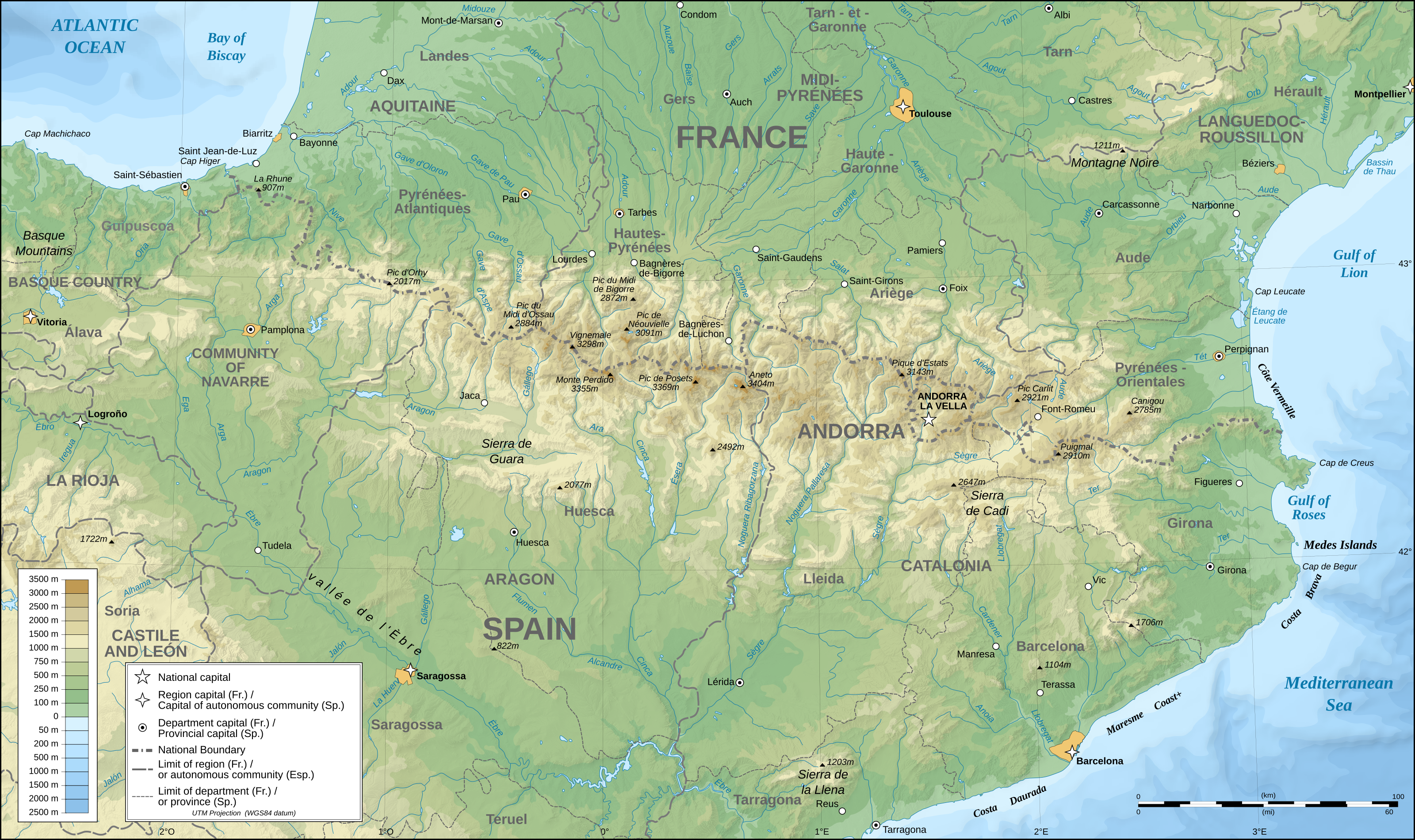
English: Topographic map in English of the Pyrenees Mountains. Note: The shaded relief is a raster image embedded in the SVG file. Français : Carte topographique des Pyrénées en english.
UTM projection; WGS84 datum; shaded relief (composite image of N-W, W and N lightning positions);Note : Le relief ombré est une image bitmap embarquée dans le fichier SVG. *The approximate horizontal accuracy of topographic data and shore/lakes limits is 1,125 m (per pixel). This map should not be printed over a 1:1 ratio (27.09 x 16.09cm), which corresponds to a scale of 1:2,010,221. *Approximate scale of the bathymetry: 1:7,708,000 (precision: 1,927 m) |
| Datums | (UTC) |
| Avots | |
| Autors |
|
| This is a retouched picture, which means that it has been digitally altered from its original version. Modifications: translation into English. The original can be viewed here: Pyrenees topographic map-fr.svg:
|
Es, šī darba autortiesību īpašnieks, publicēju to saskaņā ar šīm licencēm:
This file is licensed under the Creative Commons Attribution-Share Alike 2.5 Generic, 2.0 Generic and 1.0 Generic license.
- Jūs varat brīvi:
- koplietot – kopēt, izplatīt un pārraidīt darbu
- remiksēt – pielāgot darbu
- Saskaņā ar šādiem nosacījumiem:
- atsaucoties – Tev ir jānorāda autors, saite uz licenci un to, vai veiktas kādas izmaiņas. To var darīt jebkādā saprātīgā veidā, bet ne tādā, kas norādītu, ka licencētājs atbalsta tevi vai veidu, kā tu izmanto šo darbu.
- nemainot licenci – Ja tu miksē, pārveido vai izmanto materiālu, tev savs devums jāpublicē ar to pašu vai saderīgu licenci kā oriģināls.
| Šis fails tiek izplatīts saskaņā ar licences Creative Commons Atsauce-Līdzīgi Noteikumi 3.0 Vispārējiem noteikumiem. | ||
| ||
| This licensing tag was added to this file as part of the GFDL licensing update. |

|
Ir dota atļauja kopēt, izplatīt un/vai pārveidot šo dokumentu saskaņā ar GNU brīvās dokumentācijas licences, versijas 1.2 vai jebkuras vēlākas versijas, ko publiskojis Brīvās programmatūras fonds nosacījumiem; bez nemainīgajām sadaļā, priekšējā un aizmugurēja'vāka tekstiem. Licences kopija ir iekļauta sadaļā ar nosaukumu GNU brīvās dokumentācijas licence. |
Jūs varat izvēlēties licenci pēc jūsu vēlmes.
Original upload log
This image is a derivative work of the following images:
- File:Pyrenees_topographic_map-fr.svg licensed with Cc-by-sa-2.5,2.0,1.0, Cc-by-sa-3.0-migrated, GFDL
- 2008-09-23T15:49:03Z Sting 3200x1900 (6608359 Bytes) Using ETOPO1 data for bathymetry; new standard colors
- 2007-07-02T00:25:17Z Sting 3200x1900 (6191391 Bytes) + projection info in key ; + major cities areas ; some corrections in the rivers
- 2007-06-25T20:30:25Z Sting 3200x1900 (6166321 Bytes) + key for borders
- 2007-05-31T21:18:03Z Sting 3200x1900 (6163256 Bytes) Some corrections
- 2007-05-30T18:23:51Z Sting 3200x1900 (6163275 Bytes) {{Information |Description=Topographic map in French of the [[:en:Pyrenees|Pyrenees mountains]] |Source=Own work ;Topographic map : [http://www2.jpl.nasa.gov/srtm NASA Shuttle Radar Topography Mission] (SRTM3 v.2) (public dom
Faila hronoloģija
Uzklikšķini uz datums/laiks kolonnā esošās saites, lai apskatītos, kā šis fails izskatījās tad.
| Datums/Laiks | Attēls | Izmēri | Dalībnieks | Komentārs | |
|---|---|---|---|---|---|
| tagadējais | 2011. gada 28. maijs, plkst. 03.25 | | 3 200 × 1 900 (6,3 MB) | RedWolf | {{Information |Description={{en|Topographic map in English of the Pyrenees mountains.<br/>''Note:'' The shaded relief is a raster image embedded in the SVG file.}} {{fr|Carte topographique des Pyrénées en english.<br/ |
Faila lietojums
Šo failu izmanto šajā 1 lapā:
Globālais faila lietojums
Šīs Vikipēdijas izmanto šo failu:
- Izmantojums am.wikipedia.org
- Izmantojums ar.wikipedia.org
- Izmantojums bg.wikipedia.org
- Izmantojums bh.wikipedia.org
- Izmantojums bn.wikipedia.org
- Izmantojums ca.wikipedia.org
- Izmantojums ceb.wikipedia.org
- Izmantojums cs.wikipedia.org
- Izmantojums da.wikipedia.org
- Izmantojums en.wikipedia.org
- Pyrenees
- Col du Tourmalet
- Canigou
- Aneto
- Pic du Midi de Bigorre
- Pre-Pyrenees
- Vignemale
- Monte Perdido
- Pic du Midi d'Ossau
- Montsec Range
- Larrun
- Pica d'Estats
- Col d'Aubisque
- Mallos de Riglos
- Collarada
- Pla d'Adet
- Mount Baigura
- Balaïtous
- Col d'Ares
- Col d'Aspin
- Pic Long
- Corbières Massif
- Hautza
- La Mongie
- Pic del Port Vell
- Pic de Sanfonts
- Port de Pailhères
- Port de Balès
- Col de Portet d'Aspet
- Col de Menté
- Col de Peyresourde
- Port de Larrau
- Col de Port
- Col de Marie-Blanque
- Puigmal
- Pic Ramougn
- Soum de Ramond
Skatīt šī faila pilno globālo izmantojumu.