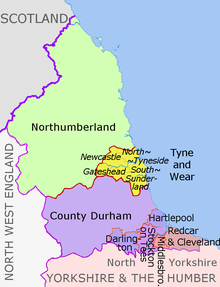
Attēls:North East England counties 2009 map.svg

Sākotnējais fails (SVG fails, definētais izmērs 1 082 × 1 345 pikseļi, faila izmērs: 723 KB)

Kopsavilkums

Apraksts
English: Map of the North East England region of England, showing its counties and administrative districts. The county colours are the same as those in File:English metropolitan and non-metropolitan counties 2009.svg.

Equirectangular map projection on WGS 84 datum, with N/S stretched 170% Geographic limits:

  • West: 2.75W
  • East: 0.7W
  • North: 55.9N
  • South: 54.4N
Datums (UTC)
Avots

Šis fails tika iegūts no:

Autors
Citas versijas
Labelled and showing biases of administrative and ceremonial borders
Map Ceremonial county Unitary authority Metropolitan districts
1. Northumberland
2. Tyne and Wear
metropolitan county
aNewcastle upon Tyne, bGateshead, cNorth Tyneside, dSouth Tyneside, eSunderland
Durham 3. Durham
4. Darlington
5. Hartlepool
6. Stockton-on-Tees
North Yorkshire
(part only)
7. Redcar and Cleveland
8. Middlesbrough

Licence

w:en:Creative Commons
atsaucoties nemainot licenci
Šis fails tiek izplatīts saskaņā ar licences Creative Commons Atsauce-Līdzīgi Noteikumi 3.0 Vispārējiem noteikumiem.
Atsauce: Dr Greg and Nilfanion. Contains Ordnance Survey data © Crown copyright and database right 2011
Jūs varat brīvi:
  • koplietot – kopēt, izplatīt un pārraidīt darbu
  • remiksēt – pielāgot darbu
Saskaņā ar šādiem nosacījumiem:
  • atsaucoties – Tev ir jānorāda autors, saite uz licenci un to, vai veiktas kādas izmaiņas. To var darīt jebkādā saprātīgā veidā, bet ne tādā, kas norādītu, ka licencētājs atbalsta tevi vai veidu, kā tu izmanto šo darbu.
  • nemainot licenci – Ja tu miksē, pārveido vai izmanto materiālu, tev savs devums jāpublicē ar to pašu vai saderīgu licenci kā oriģināls.

Original upload log

This image is a derivative work of the following images:

  • File:North_East_England__districts_2011_map.svg licensed with Cc-by-sa-3.0, GFDL
    • 2011-05-01T18:56:43Z Nilfanion 1082x1345 (714062 Bytes) == Summary == {{Information |Description=Map of the [[w:North East England|North East England]] region showing the administrative districts. Equirectangular map projection on WGS 84 datum, with N/S stretched 170% Geographic
  • File:English_ceremonial_counties_2010.svg licensed with Cc-by-sa-3.0, GFDL
    • 2010-11-23T16:39:55Z Nilfanion 1108x1345 (308868 Bytes) thicker lines
    • 2010-11-23T16:20:19Z Nilfanion 1108x1345 (301520 Bytes) tweaks
    • 2010-10-26T20:34:20Z Nilfanion 817x990 (1391832 Bytes) {{Information |Description=Map showing the [[w:ceremonial counties of England]] including the City of London, in 2010. Equirectangular map projection on WGS 84 datum, with N/S stretched 170% Geographic limits: *West: 6.75W

Uploaded with derivativeFX

Captions

Pievieno vienas rindiņas aprakstu, ko šis fails attēlo

Šajā failā attēlotais

attēlo

1 maijs 2012

image/svg+xml

Faila hronoloģija

Uzklikšķini uz datums/laiks kolonnā esošās saites, lai apskatītos, kā šis fails izskatījās tad.

Datums/LaiksAttēlsIzmēriDalībnieksKomentārs
tagadējais2018. gada 14. augusts, plkst. 22.162018. gada 14. augusts, plkst. 22.16 versijas sīktēls1 082 × 1 345 (723 KB)Inopschange letters labelling the boroughs of Tyne and Wearfrom white to black. Hardly intelligible when thumbnailed otherwise
2012. gada 5. maijs, plkst. 22.112012. gada 5. maijs, plkst. 22.11 versijas sīktēls1 082 × 1 345 (723 KB)Dr Greglighten black boundary line
2012. gada 2. maijs, plkst. 00.212012. gada 2. maijs, plkst. 00.21 versijas sīktēls1 082 × 1 345 (723 KB)Dr Greg== {{int:filedesc}} == {{Information |Description={{en|Map of the North East England region of England, showing its counties and administrative districts. The county colours are the same as those in [[:File:English metropolitan...

Šo failu izmanto šajā 1 lapā:

Globālais faila lietojums

Šīs Vikipēdijas izmanto šo failu:

Metadati