Attēls:NAVAREA.jpg
Šī priekšskata izmērs: 788 × 599 pikseļi. Citi izmēri: 316 × 240 pikseļi | 631 × 480 pikseļi | 1 010 × 768 pikseļi | 1 024 × 779 pikseļi.
Sākotnējais fails (1 024 × 779 pikseļi, faila izmērs: 236 KB, MIME tips: image/jpeg)
| Šis fails ir no Vikikrātuves. Tā apraksts no attēla lapas Vikikrātuvē ir parādīts zemāk. Vikikrātuve ir brīvi licencēta failu krātuve. Tu vari tai palīdzēt. |

|
This map image could be re-created using vector graphics as an SVG file. This has several advantages; see Commons:Media for cleanup for more information. If an SVG form of this image is available, please upload it and afterwards replace this template with
{{vector version available|new image name}}.
It is recommended to name the SVG file “NAVAREA.svg”—then the template Vector version available (or Vva) does not need the new image name parameter. |


Kopsavilkums
| Apraksts |
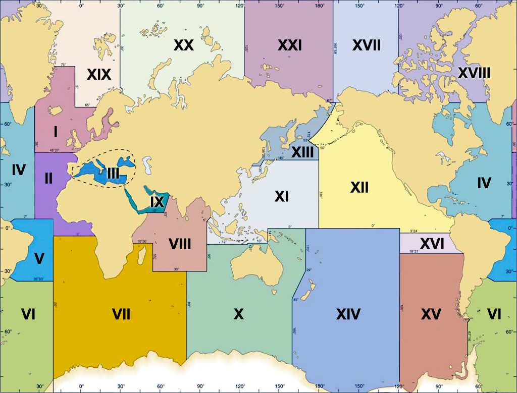
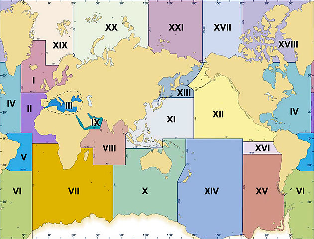
English: Map of the 21 NAVAREAS (or METAREAS) into which all the world's oceans are divided. Each serves to allocate responsibility for sending Marine and Safety Information (navigational and weather warnings) to ships at sea, as part of the GMDSS (Global Maritime Distress and Safety System).
|
| Datums | |
| Avots | Paša darbs based on http://www.navcen.uscg.gov/pdf/NAVAREA.pdf (PD-USGov license) |
| Autors | Chrumps |
| Citas versijas | File:NavareasUSCGMap.png |
Licence
Es, šī darba autortiesību īpašnieks, publicēju to saskaņā ar šo licenci:
| This file is made available under the Creative Commons CC0 1.0 Universal Public Domain Dedication. | |
| The person who associated a work with this deed has dedicated the work to the public domain by waiving all of their rights to the work worldwide under copyright law, including all related and neighboring rights, to the extent allowed by law. You can copy, modify, distribute and perform the work, even for commercial purposes, all without asking permission.
|
Faila hronoloģija
Uzklikšķini uz datums/laiks kolonnā esošās saites, lai apskatītos, kā šis fails izskatījās tad.
| Datums/Laiks | Attēls | Izmēri | Dalībnieks | Komentārs | |
|---|---|---|---|---|---|
| tagadējais | 2012. gada 28. jūlijs, plkst. 19.19 | | 1 024 × 779 (236 KB) | Chrumps | {{Information |Description ={{en|1=Map of the 21 NAVAREAS (or METAREAS) into which all the world's oceans are divided. Each serves to allocate responsibility for sending Marine and Safety Information (navigational and weather warnings) to ships at s... |
Faila lietojums
Šo failu izmanto šajās 2 lapās:
Globālais faila lietojums
Šīs Vikipēdijas izmanto šo failu:
- Izmantojums es.wikipedia.org
- Izmantojums ja.wikipedia.org
- Izmantojums pl.wikipedia.org
- Izmantojums www.wikidata.org