Attēls:Memorial Gardens (geograph 5531397).jpg

Šī priekšskata izmērs: 800 × 530 pikseļi. Citi izmēri: 320 × 212 pikseļi | 640 × 424 pikseļi | 1 000 × 662 pikseļi.
Sākotnējais fails (1 000 × 662 pikseļi, faila izmērs: 740 KB, MIME tips: image/jpeg)
| Šis fails ir no Vikikrātuves. Tā apraksts no attēla lapas Vikikrātuvē ir parādīts zemāk. Vikikrātuve ir brīvi licencēta failu krātuve. Tu vari tai palīdzēt. |
.jpg?uselang=lv)
Kopsavilkums
| Apraksts |
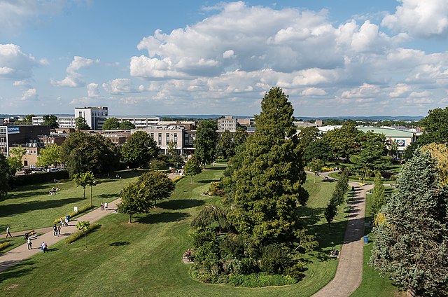
English: Green Flag park in central Crawley, originally purchased in 1921 using funds raised by the local community to serve as a public recreation ground in memory of those who had lost their lives during the Great War. Seen here from the car park of County Mall shopping centre.
In the far distance can be seen the line of the North Downs near Reigate. |
| Datums | |
| Avots | From geograph.org.uk |
| Autors | Ian Capper |
| Atļauja: (Šī faila izmantošana citur) |
Creative Commons Attribution Share-alike license 2.0 |
| Atsauce (required by the license) | Ian Capper / Memorial Gardens / |
| Camera location | | View this and other nearby images on: OpenStreetMap |
|---|
.jpg¶ms=051.113915_N_-000.184577_E_globe:Earth_type:camera_source:geograph-osgb36(TQ2717136525)_heading:0.00&language=lv)
| Object location | | View this and other nearby images on: OpenStreetMap |
|---|
.jpg¶ms=051.114380_N_-000.184590_E_globe:Earth_class:object_type:object_source:geograph-osgb36(TQ2716936577)_heading:0.00&language=lv)
Licence

|
This image was taken from the Geograph project collection. See this photograph's page on the Geograph website for the photographer's contact details. The copyright on this image is owned by Ian Capper and is licensed for reuse under the Creative Commons Attribution-ShareAlike 2.0 license.
|
Šis fails tiek izplatīts saskaņā ar licences Creative Commons Atsauce-Līdzīgi Noteikumi 2.0 Vispārējiem noteikumiem.
Atsauce: Ian Capper
- Jūs varat brīvi:
- koplietot – kopēt, izplatīt un pārraidīt darbu
- remiksēt – pielāgot darbu
- Saskaņā ar šādiem nosacījumiem:
- atsaucoties – Tev ir jānorāda autors, saite uz licenci un to, vai veiktas kādas izmaiņas. To var darīt jebkādā saprātīgā veidā, bet ne tādā, kas norādītu, ka licencētājs atbalsta tevi vai veidu, kā tu izmanto šo darbu.
- nemainot licenci – Ja tu miksē, pārveido vai izmanto materiālu, tev savs devums jāpublicē ar to pašu vai saderīgu licenci kā oriģināls.
Faila hronoloģija
Uzklikšķini uz datums/laiks kolonnā esošās saites, lai apskatītos, kā šis fails izskatījās tad.
| Datums/Laiks | Attēls | Izmēri | Dalībnieks | Komentārs | |
|---|---|---|---|---|---|
| tagadējais | 2023. gada 15. februāris, plkst. 02.33 | | 1 000 × 662 (740 KB) | Chocolateediter | == {{int:filedesc}} == {{Information |Description={{en|1= Green Flag park in central Crawley, originally purchased in 1921 using funds raised by the local community to serve as a public recreation ground in memory of those who had lost their lives during the Great War. Seen here from the car park of County Mall shopping centre. In the far distance can be seen the line of the North Downs near Reigate.}} |Source=From [https://www.geograph.org.uk/photo/5531397 geograph.org.uk] |Date=2017-09-02... |
Faila lietojums
Šo failu izmanto šajā 1 lapā:
Globālais faila lietojums
Šīs Vikipēdijas izmanto šo failu:
- Izmantojums en.wikipedia.org
.jpg)