Attēls:Ivan 2004-09-13 1555Z.jpg

Šī priekšskata izmērs: 461 × 599 pikseļi. Citi izmēri: 184 × 240 pikseļi | 369 × 480 pikseļi | 591 × 768 pikseļi | 788 × 1 024 pikseļi | 1 575 × 2 048 pikseļi | 6 000 × 7 800 pikseļi.
Sākotnējais fails (6 000 × 7 800 pikseļi, faila izmērs: 6,43 MB, MIME tips: image/jpeg)
| Šis fails ir no Vikikrātuves. Tā apraksts no attēla lapas Vikikrātuvē ir parādīts zemāk. Vikikrātuve ir brīvi licencēta failu krātuve. Tu vari tai palīdzēt. |
Kopsavilkums
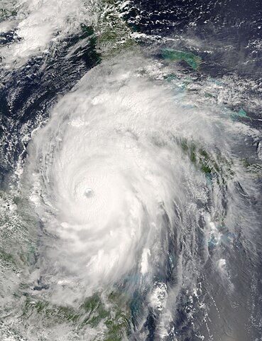
| Apraksts | Now a powerful and rare Category 5 storm, Hurricane Ivan is moving between Cuba, right, and the Yucatan Peninsula, left into the Gulf of Mexico. When the Moderate Resolution Imaging Spectroradiometer (MODIS) on NASA’s Terra satellite acquired this image at 15:55 UTC (10:55 a.m. EDT) on September 13, 2004, the storm boasted winds of 260 kilometers per hour (160 mph). The storm was located about 110 kilometers southeast of Cuba, and was moving northwest at 13 kilometers per hour (8 mph). For more information about Ivan, please visit the National Hurricane Center. | |||||
| Datums | ||||||
| Avots | http://visibleearth.nasa.gov/view_rec.php?id=6640 | |||||
| Autors | Jacques Descloitres, MODIS Rapid Response Team, NASA/GSFC | |||||
| Atļauja: (Šī faila izmantošana citur) |
|

Faila hronoloģija
Uzklikšķini uz datums/laiks kolonnā esošās saites, lai apskatītos, kā šis fails izskatījās tad.
| Datums/Laiks | Attēls | Izmēri | Dalībnieks | Komentārs | |
|---|---|---|---|---|---|
| tagadējais | 2006. gada 23. septembris, plkst. 17.55 | | 6 000 × 7 800 (6,43 MB) | Good kitty | == Summary == {{Information |Description=Now a powerful and rare Category 5 storm, Hurricane Ivan is moving between Cuba, right, and the Yucatan Peninsula, left into the Gulf of Mexico. When the Moderate Resolution Imaging Spectroradiometer (MODIS) on NAS |
Faila lietojums
Šo failu izmanto šajā 1 lapā:
Globālais faila lietojums
Šīs Vikipēdijas izmanto šo failu:
- Izmantojums de.wikipedia.org
- Izmantojums en.wikipedia.org
- Izmantojums fr.wikipedia.org
- Izmantojums pt.wikipedia.org