Attēls:Imberhorne Viaduct - geograph.org.uk - 771698.jpg
Augstāka izšķirtspēja nav pieejama.
Imberhorne_Viaduct_-_geograph.org.uk_-_771698.jpg (640 × 479 pikseļi, faila izmērs: 130 KB, MIME tips: image/jpeg)
| Šis fails ir no Vikikrātuves. Tā apraksts no attēla lapas Vikikrātuvē ir parādīts zemāk. Vikikrātuve ir brīvi licencēta failu krātuve. Tu vari tai palīdzēt. |
Kopsavilkums
| Apraksts |
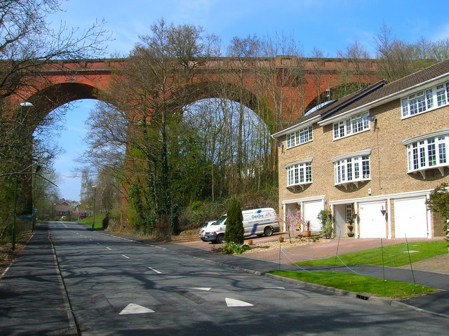
English: Imberhorne Viaduct Built in 1882 to carry the branch line from Lewes over a small Wealden valley and into East Grinstead. The line was closed in 1958 but the viaduct somehow survived being used by British rail as a turning point for their now terminus in East Grinstead. In recent years it has been purchased by the Bluebell Railway who are currently building an extension of their line from Kingscote to rejoin the main network nearby. In the near future steam trains will once again be seen travelling over the viaduct. This view is of three of the nine arches south of the viaduct. |
| Datums | |
| Avots | From geograph.org.uk |
| Autors | Simon Carey |
| Atsauce (required by the license) | Simon Carey / Imberhorne Viaduct / |
| Camera location | | View this and other nearby images on: OpenStreetMap |
|---|
_heading:292.00&language=lv)
| Object location | | View this and other nearby images on: OpenStreetMap |
|---|
_heading:292.00&language=lv)
Licence

|
This image was taken from the Geograph project collection. See this photograph's page on the Geograph website for the photographer's contact details. The copyright on this image is owned by Simon Carey and is licensed for reuse under the Creative Commons Attribution-ShareAlike 2.0 license.
|
Šis fails tiek izplatīts saskaņā ar licences Creative Commons Atsauce-Līdzīgi Noteikumi 2.0 Vispārējiem noteikumiem.
Atsauce: Simon Carey
- Jūs varat brīvi:
- koplietot – kopēt, izplatīt un pārraidīt darbu
- remiksēt – pielāgot darbu
- Saskaņā ar šādiem nosacījumiem:
- atsaucoties – Tev ir jānorāda autors, saite uz licenci un to, vai veiktas kādas izmaiņas. To var darīt jebkādā saprātīgā veidā, bet ne tādā, kas norādītu, ka licencētājs atbalsta tevi vai veidu, kā tu izmanto šo darbu.
- nemainot licenci – Ja tu miksē, pārveido vai izmanto materiālu, tev savs devums jāpublicē ar to pašu vai saderīgu licenci kā oriģināls.
Faila hronoloģija
Uzklikšķini uz datums/laiks kolonnā esošās saites, lai apskatītos, kā šis fails izskatījās tad.
| Datums/Laiks | Attēls | Izmēri | Dalībnieks | Komentārs | |
|---|---|---|---|---|---|
| tagadējais | 2011. gada 20. februāris, plkst. 01.06 | | 640 × 479 (130 KB) | GeographBot | == {{int:filedesc}} == {{Information |description={{en|1=Imberhorne Viaduct Built in 1882 to carry the branch line from Lewes over a small Wealden valley and into East Grinstead. The line was closed in 1958 but the viaduct somehow survived being used by B |
Faila lietojums
Šo failu izmanto šajā 1 lapā:
Globālais faila lietojums
Šīs Vikipēdijas izmanto šo failu:
- Izmantojums azb.wikipedia.org
- Izmantojums de.wikipedia.org
- Izmantojums en.wikipedia.org
- Izmantojums ru.wikipedia.org
- Izmantojums www.wikidata.org