Attēls:Hispania 3a division provincial.PNG
Hispania_3a_division_provincial.PNG (506 × 357 pikseļi, faila izmērs: 10 KB, MIME tips: image/png)
| Šis fails ir no Vikikrātuves. Tā apraksts no attēla lapas Vikikrātuvē ir parādīts zemāk. Vikikrātuve ir brīvi licencēta failu krātuve. Tu vari tai palīdzēt. |

|
This locator map image could be re-created using vector graphics as an SVG file. This has several advantages; see Commons:Media for cleanup for more information. If an SVG form of this image is available, please upload it and afterwards replace this template with
{{vector version available|new image name}}.
It is recommended to name the SVG file “Hispania 3a division provincial.svg”—then the template Vector version available (or Vva) does not need the new image name parameter. |
Kopsavilkums
| Apraksts |
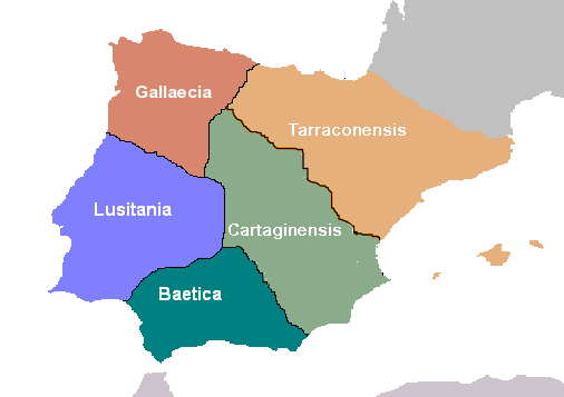
Español: Hispania: División provincial de Diocleciano.
Deutsch: Hispania: Einteilung der Provinzen unter Diocletian. |
| Datums | |
| Avots | Paša darbs |
| Autors | Hispa |
Licence

|
This work is free software; you can redistribute it and/or modify it under the terms of the GNU General Public License as published by the Free Software Foundation; either version 2 of the License, or any later version. This work is distributed in the hope that it will be useful, but without any warranty; without even the implied warranty of merchantability or fitness for a particular purpose. See version 2 and version 3 of the GNU General Public License for more details. |
Faila hronoloģija
Uzklikšķini uz datums/laiks kolonnā esošās saites, lai apskatītos, kā šis fails izskatījās tad.
| Datums/Laiks | Attēls | Izmēri | Dalībnieks | Komentārs | |
|---|---|---|---|---|---|
| tagadējais | 2006. gada 19. jūnijs, plkst. 09.17 | | 506 × 357 (10 KB) | Hispa | Repainted version of Hispania's Diocletian division, with better defined frontiers for Cartaginensis province. |
| 2006. gada 15. maijs, plkst. 19.35 |  | 506 × 357 (13 KB) | Rodriguillo | Bueno... esta creo que ya es la buena | |
| 2006. gada 15. maijs, plkst. 15.32 |  | 511 × 357 (10 KB) | Rodriguillo | ||
| 2006. gada 15. maijs, plkst. 15.25 |  | 511 × 357 (13 KB) | Rodriguillo | Revisión hecha por Rodriguillo: las islas Baleares, tras la división de Diocleciano, pertenecían a la Cartaginense | |
| 2006. gada 15. maijs, plkst. 15.24 |  | 511 × 357 (13 KB) | Rodriguillo | Revisión hecha por Rodriguillo: las islas Baleares, tras la división de Diocleciano, pertenecían a la Cartaginense. | |
| 2005. gada 11. decembris, plkst. 16.32 |  | 511 × 357 (10 KB) | Hispa | Better defined provincial borders | |
| 2005. gada 30. oktobris, plkst. 01.10 |  | 511 × 358 (11 KB) | Hispa | ||
| 2005. gada 29. oktobris, plkst. 23.07 |  | 512 × 421 (14 KB) | Hispa | División provincial de Diocleciano, creado por Hispa Category:Historical maps Category:Maps of Spain |
Faila lietojums
Šo failu neizmanto nevienā lapā.
Globālais faila lietojums
Šīs Vikipēdijas izmanto šo failu:
- Izmantojums an.wikipedia.org
- Izmantojums ast.wiktionary.org
- Izmantojums ca.wikipedia.org
- Izmantojums da.wikipedia.org
- Izmantojums de.wikipedia.org
- Izmantojums de.wikibooks.org
- Izmantojums es.wikipedia.org
- Izmantojums eu.wikipedia.org
- Izmantojums fa.wikipedia.org
- Izmantojums fr.wikipedia.org
- Izmantojums gl.wikipedia.org
- Izmantojums he.wikipedia.org
- Izmantojums it.wikipedia.org
- Izmantojums mk.wikipedia.org
- Izmantojums nl.wikipedia.org
- Izmantojums no.wikipedia.org
- Izmantojums oc.wikipedia.org
- Izmantojums sh.wikipedia.org
- Izmantojums sr.wikipedia.org
Skatīt šī faila pilno globālo izmantojumu.