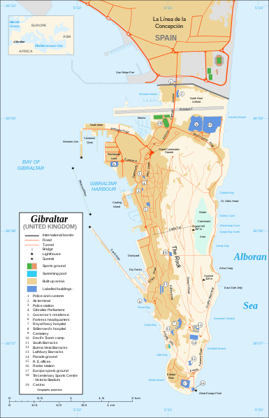
Attēls:Gibraltar map-en.svg

Size of this PNG preview of this SVG file: 385 × 598 pikseļi. Citi izmēri: 154 × 240 pikseļi | 309 × 480 pikseļi | 494 × 768 pikseļi | 659 × 1 024 pikseļi | 1 317 × 2 048 pikseļi | 2 020 × 3 140 pikseļi.
Sākotnējais fails (SVG fails, definētais izmērs 2 020 × 3 140 pikseļi, faila izmērs: 289 KB)
Faila hronoloģija
Uzklikšķini uz datums/laiks kolonnā esošās saites, lai apskatītos, kā šis fails izskatījās tad.
| Datums/Laiks | Attēls | Izmēri | Dalībnieks | Komentārs | |
|---|---|---|---|---|---|
| tagadējais | 2020. gada 21. februāris, plkst. 23.10 |  | 2 020 × 3 140 (289 KB) | JoKalliauer | malformed svg (compare firefox/chrome rendering with librsvg-rendering) actually firefox/chrome were correct, also it looks wrong |
| 2017. gada 29. jūnijs, plkst. 09.01 |  | 2 020 × 3 140 (538 KB) | Wereldburger758 | Removal error in file. Valid SVG now. | |
| 2008. gada 28. augusts, plkst. 00.52 |  | 2 020 × 3 140 (569 KB) | RedCoat | Remove "claimed by Spain", completely gratuitous for a map | |
| 2007. gada 11. decembris, plkst. 14.28 |  | 2 020 × 3 140 (570 KB) | Sting | Notification of the Spanish claims | |
| 2007. gada 27. novembris, plkst. 17.40 |  | 2 020 × 3 140 (569 KB) | Sting | Additional names ; up-to-date corrections | |
| 2007. gada 27. novembris, plkst. 00.35 |  | 2 020 × 3 140 (561 KB) | RedCoat | House of Assembly → Gibraltar Parliament | |
| 2007. gada 26. novembris, plkst. 22.51 |  | 2 020 × 3 140 (561 KB) | Sting | + info | |
| 2007. gada 26. novembris, plkst. 17.12 |  | 2 020 × 3 140 (561 KB) | Sting | + info | |
| 2007. gada 26. novembris, plkst. 16.21 |  | 2 020 × 3 140 (561 KB) | Sting | {{Information |Description=Map in English of Gibraltar |Source=Own work ;<br/>Map created using screenshots of Google Earth satellite imagery from a point of view located at 1.18 km of altitude (available image |
Faila lietojums
Šo failu neizmanto nevienā lapā.
Globālais faila lietojums
Šīs Vikipēdijas izmanto šo failu:
- Izmantojums ar.wikipedia.org
- Izmantojums azb.wikipedia.org
- Izmantojums ca.wikipedia.org
- Izmantojums de.wikipedia.org
- Izmantojums en.wikipedia.org
- Izmantojums fi.wikipedia.org
- Izmantojums fr.wikipedia.org
- Izmantojums fy.wikipedia.org
- Izmantojums hi.wikipedia.org
- Izmantojums id.wikipedia.org
- Izmantojums incubator.wikimedia.org
- Izmantojums ja.wikipedia.org
- Izmantojums la.wikipedia.org
- Izmantojums mzn.wikipedia.org
- Izmantojums nl.wikipedia.org
- Izmantojums no.wikipedia.org
- Izmantojums pa.wikipedia.org
- Izmantojums pl.wikipedia.org
- Izmantojums pt.wikipedia.org
- Izmantojums ru.wikipedia.org
- Izmantojums sc.wikipedia.org
- Izmantojums smn.wikipedia.org
- Izmantojums uk.wikipedia.org
- Izmantojums www.wikidata.org


