Attēls:Falklandinseln Karte deutsch.jpg
Augstāka izšķirtspēja nav pieejama.
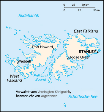
Falklandinseln_Karte_deutsch.jpg (350 × 376 pikseļi, faila izmērs: 136 KB, MIME tips: image/jpeg)
| Šis fails ir no Vikikrātuves. Tā apraksts no attēla lapas Vikikrātuvē ir parādīts zemāk. Vikikrātuve ir brīvi licencēta failu krātuve. Tu vari tai palīdzēt. |
Map of the Falkland islands in the south Atlantic ocean
Uploaded to de: by ChristianGlaeser on May 3, 2004
This image is in the public domain because it contains materials that originally came from the United States Central Intelligence Agency's World Factbook.
|
 |
Faila hronoloģija
Uzklikšķini uz datums/laiks kolonnā esošās saites, lai apskatītos, kā šis fails izskatījās tad.
| Datums/Laiks | Attēls | Izmēri | Dalībnieks | Komentārs | |
|---|---|---|---|---|---|
| tagadējais | 2005. gada 26. jūlijs, plkst. 18.11 | | 350 × 376 (136 KB) | Thuresson | Map of the Falkland islands in the south Atlantic ocean Uploaded to de: by ChristianGlaeser on May 3, 2004 {{PD-USGov-CIA-WF}} Category:Maps of Falkland Islands |
Faila lietojums
Šo failu izmanto šajās 2 lapās:
Globālais faila lietojums
Šīs Vikipēdijas izmanto šo failu:
- Izmantojums be.wikipedia.org
- Izmantojums krc.wikipedia.org
- Izmantojums tt.wikipedia.org
- Izmantojums uk.wikipedia.org