Attēls:Europe about 1560.jpg

Šī priekšskata izmērs: 745 × 599 pikseļi. Citi izmēri: 298 × 240 pikseļi | 597 × 480 pikseļi | 955 × 768 pikseļi | 1 273 × 1 024 pikseļi | 2 398 × 1 929 pikseļi.
Sākotnējais fails (2 398 × 1 929 pikseļi, faila izmērs: 1,25 MB, MIME tips: image/jpeg)
| Šis fails ir no Vikikrātuves. Tā apraksts no attēla lapas Vikikrātuvē ir parādīts zemāk. Vikikrātuve ir brīvi licencēta failu krātuve. Tu vari tai palīdzēt. |
Kopsavilkums
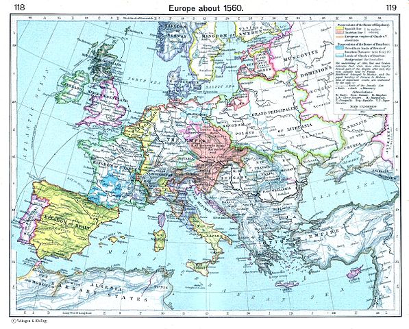
| Apraksts | Europe about 1560 |
| Datums | |
| Avots | The Historical Atlas by William R. Shepherd, 1923. Downloaded from [1] |
| Autors | William R. Shepherd (died 1934) [2] |
| Atļauja: (Šī faila izmantošana citur) |
Public domain |
_en.png)
.png)
.jpg)
Licence
|
This work is in the public domain in its country of origin and other countries and areas where the copyright term is the author's life plus 70 years or fewer. | |
| This file has been identified as being free of known restrictions under copyright law, including all related and neighboring rights. | |
Faila hronoloģija
Uzklikšķini uz datums/laiks kolonnā esošās saites, lai apskatītos, kā šis fails izskatījās tad.
| Datums/Laiks | Attēls | Izmēri | Dalībnieks | Komentārs | |
|---|---|---|---|---|---|
| tagadējais | 2009. gada 21. aprīlis, plkst. 22.41 | | 2 398 × 1 929 (1,25 MB) | Alex:D | == Summary == {{Information |Description=Europe about 1560 |Source=The Historical Atlas by William R. Shepherd, 1923. Downloaded from [http://www.reisenett.no/map_collection/historical/history_balkans.html] |Date=1923 |Author=William R. Shepherd (died 193 |
Faila lietojums
Šo failu neizmanto nevienā lapā.
Globālais faila lietojums
Šīs Vikipēdijas izmanto šo failu:
- Izmantojums ast.wikipedia.org
- Izmantojums en.wikipedia.org
- Izmantojums es.wikipedia.org
- Izmantojums et.wikipedia.org
- Izmantojums eu.wikipedia.org
- Izmantojums fa.wikipedia.org
- Izmantojums tr.wikipedia.org