Attēls:ElectoralCollege1789.svg

Size of this PNG preview of this SVG file: 542 × 446 pikseļi. Citi izmēri: 292 × 240 pikseļi | 583 × 480 pikseļi | 933 × 768 pikseļi | 1 245 × 1 024 pikseļi | 2 489 × 2 048 pikseļi.
Sākotnējais fails (SVG fails, definētais izmērs 542 × 446 pikseļi, faila izmērs: 49 KB)
| Šis fails ir no Vikikrātuves. Tā apraksts no attēla lapas Vikikrātuvē ir parādīts zemāk. Vikikrātuve ir brīvi licencēta failu krātuve. Tu vari tai palīdzēt. |
| U.S. presidential election maps (SVG) |
| See also: National Atlas maps (png) |
|
1789 · 1792 · 1796 · 1800 · 1804 · 1808 · 1812 · 1816 · 1820 · 1824 · 1828 · 1832 · 1836 · 1840 · 1844 · 1848 · 1852 · 1856 · 1860 · 1864 · 1868 · 1872 · 1876 · 1880 · 1884 · 1888 · 1892 · 1896 · 1900 · 1904 · 1908 · 1912 · 1916 · 1920 · 1924 · 1928 · 1932 · 1936 · 1940 · 1944 · 1948 · 1952 · 1956 · 1960 · 1964 · 1968 · 1972 · 1976 · 1980 · 1984 · 1988 · 1992 · 1996 · 2000 · 2004 · 2008 · 2012 · 2016 · 2020 · 2024 |
Kopsavilkums
| Apraksts |
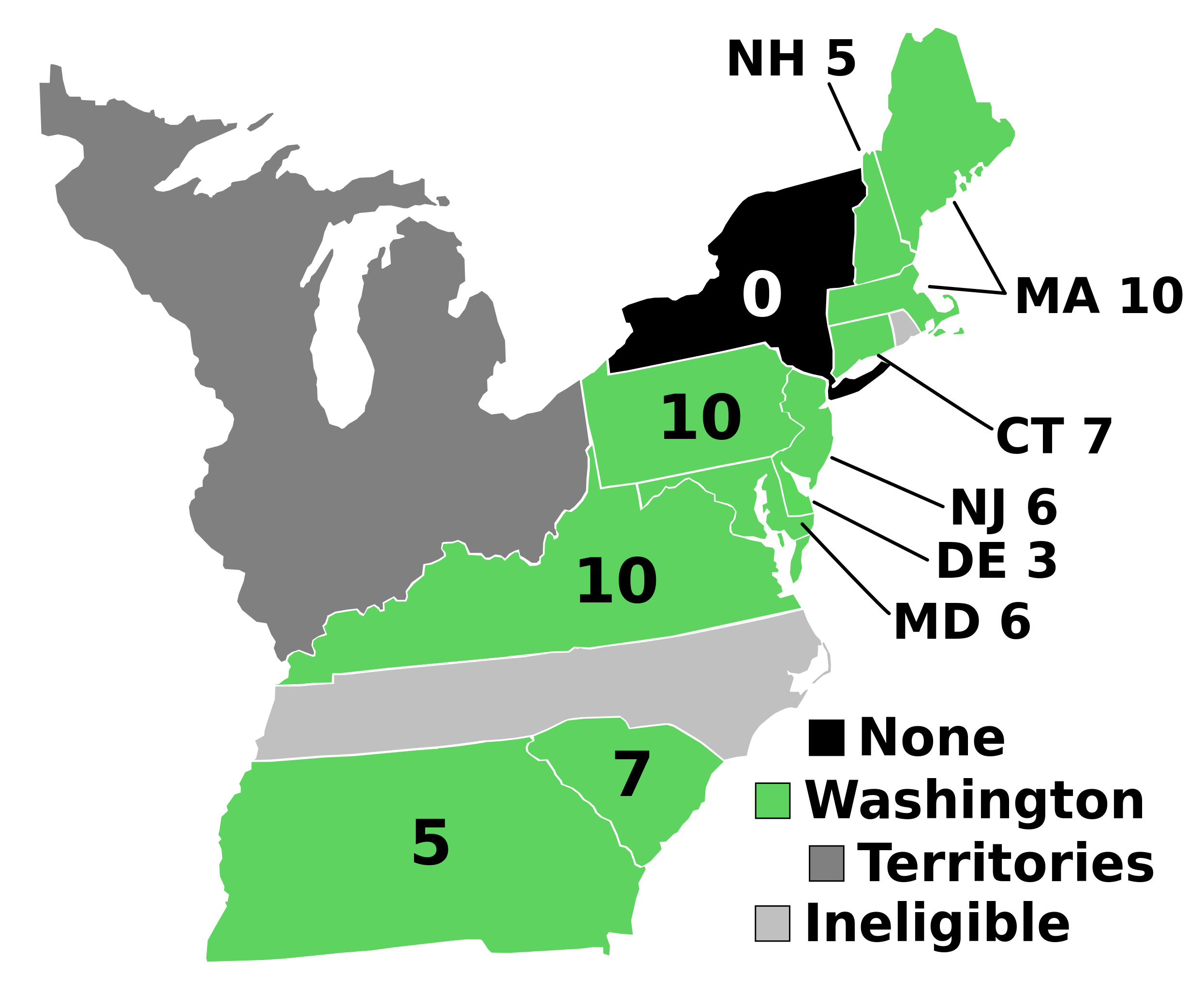
English: Electoral votes by state.
Note: North Carolina and Rhode Island had not yet ratified the Constitution so were therefore ineligible to choose electors. The New York legislature was deadlocked so therefore no electors were chosen. Vermont had been acting independently, but was still considered part of New York at the time. עברית: חלוקת האלקטורים לפי מדינה. |
| Avots | Paša darbs |
| Autors | AndyHogan14 |
| Citas versijas |
Derivative works of this file: |
| SVG development | W3C-validity not checked. |
Licence
| I, the copyright holder of this work, release this work into the public domain. This applies worldwide. In some countries this may not be legally possible; if so: I grant anyone the right to use this work for any purpose, without any conditions, unless such conditions are required by law. |
Faila hronoloģija
Uzklikšķini uz datums/laiks kolonnā esošās saites, lai apskatītos, kā šis fails izskatījās tad.
| Datums/Laiks | Attēls | Izmēri | Dalībnieks | Komentārs | |
|---|---|---|---|---|---|
| tagadējais | 2023. gada 2. septembris, plkst. 20.02 | | 542 × 446 (49 KB) | Clarinetguy097 | This should fix the issue with text being cut off. |
| 2023. gada 2. septembris, plkst. 19.49 |  | 542 × 446 (49 KB) | Clarinetguy097 | I'd instead argue that North Carolina and Rhode Island didn't stop being part of the US when the Constitution went into effect. | |
| 2021. gada 29. oktobris, plkst. 07.40 |  | 542 × 446 (38 KB) | Fluffy89502 | NC & RI were not a part of the United States | |
| 2020. gada 23. maijs, plkst. 07.46 |  | 542 × 446 (40 KB) | Spellcheck | Recreated based on 1800 map for consistency Also added legend entry for ineligible states | |
| 2016. gada 14. novembris, plkst. 09.46 |  | 535 × 437 (35 KB) | Wow | New York and font | |
| 2010. gada 22. maijs, plkst. 07.38 |  | 535 × 437 (29 KB) | Ibagli | No DC in 1789 | |
| 2008. gada 31. decembris, plkst. 22.38 |  | 535 × 437 (28 KB) | AndyHogan14 | {{Information |Description= |Source=self-made |Date= |Author= AndyHogan14 |Permission= |other_versions= }} |
Faila lietojums
Šo failu izmanto šajā 1 lapā:
Globālais faila lietojums
Šīs Vikipēdijas izmanto šo failu:
- Izmantojums ca.wikipedia.org
- Izmantojums cs.wikipedia.org
- Izmantojums da.wikipedia.org
- Izmantojums de.wikipedia.org
- Izmantojums el.wikipedia.org
- Izmantojums en.wikipedia.org
- 1788–89 United States presidential election
- List of United States presidential election results by state
- United States presidential election
- 1788–89 United States presidential election in Pennsylvania
- 1788–89 United States elections
- 1788–89 United States presidential election in Connecticut
- 1788–89 United States presidential election in Massachusetts
- 1788–89 United States presidential election in New Hampshire
- 1788–89 United States presidential election in New Jersey
- 1788–89 United States presidential election in South Carolina
- 1788–89 United States presidential election in Delaware
- 1788–89 United States presidential election in Georgia
- 1788–89 United States presidential election in Maryland
- 1788–89 United States presidential election in Virginia
- User:Speedicus/sandbox
- Template:State results of the 1788–89 U.S. presidential election
- Electoral history of John Adams
- Izmantojums es.wikipedia.org
- Izmantojums fi.wikipedia.org
- Izmantojums fr.wikipedia.org
- Izmantojums he.wikipedia.org
- Izmantojums it.wikipedia.org
- Izmantojums ja.wikipedia.org
- Izmantojums ko.wikipedia.org
- Izmantojums lt.wikipedia.org
- Izmantojums mk.wikipedia.org
- Izmantojums nl.wikipedia.org
- Izmantojums pl.wikipedia.org
- Izmantojums ru.wikipedia.org
- Izmantojums simple.wikipedia.org
- Izmantojums si.wikipedia.org
- Izmantojums sr.wikipedia.org
- Izmantojums sv.wikipedia.org
- Izmantojums tr.wikipedia.org
- Izmantojums vi.wikipedia.org
- Izmantojums www.wikidata.org
- Izmantojums zh.wikipedia.org