Attēls:Dallas County Texas Incorporated Areas Dallas highlighted.svg

Size of this PNG preview of this SVG file: 800 × 457 pikseļi. Citi izmēri: 320 × 183 pikseļi | 640 × 366 pikseļi | 1 024 × 585 pikseļi | 1 280 × 731 pikseļi | 2 560 × 1 463 pikseļi.
Sākotnējais fails (SVG fails, definētais izmērs 1 050 × 600 pikseļi, faila izmērs: 248 KB)
| Šis fails ir no Vikikrātuves. Tā apraksts no attēla lapas Vikikrātuvē ir parādīts zemāk. Vikikrātuve ir brīvi licencēta failu krātuve. Tu vari tai palīdzēt. |
Kopsavilkums
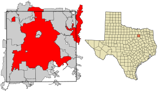
| Apraksts | This map shows the incorporated areas in Dallas County, Texas. Dallas is highlighted in red. I created it in Inkscape using data from the following links: North Central Texas Council of Governments Maps Website, Dallas County Commissioner District Map (PDF) |
| Datums | |
| Avots | My own work, based on government information. Though I strove to be as accurate in the detail as possible, the information shown is not guaranteed to be completely accurate. |
| Autors | Ixnayonthetimmay |
| Atļauja: (Šī faila izmantošana citur) |
Public Domain |
| Citas versijas | See Category:Maps of Dallas County, Texas for other versions of this image. |
Licence
| I, the copyright holder of this work, release this work into the public domain. This applies worldwide. In some countries this may not be legally possible; if so: I grant anyone the right to use this work for any purpose, without any conditions, unless such conditions are required by law. |
Faila hronoloģija
Uzklikšķini uz datums/laiks kolonnā esošās saites, lai apskatītos, kā šis fails izskatījās tad.
| Datums/Laiks | Attēls | Izmēri | Dalībnieks | Komentārs | |
|---|---|---|---|---|---|
| tagadējais | 2007. gada 9. augusts, plkst. 21.27 | | 1 050 × 600 (248 KB) | Ixnayonthetimmay | == Summary == {{Information |Description=This map shows the incorporated areas in Dallas County, Texas. Dallas is highlighted in red. I created it in [[en:Inkscape|Inkscape] |
Faila lietojums
Šo failu izmanto šajā 1 lapā:
Globālais faila lietojums
Šīs Vikipēdijas izmanto šo failu:
- Izmantojums als.wikipedia.org
- Izmantojums ar.wikipedia.org
- Izmantojums bn.wikipedia.org
- Izmantojums br.wikipedia.org
- Izmantojums ckb.wikipedia.org
- Izmantojums de.wikipedia.org
- Izmantojums en.wikipedia.org
- Izmantojums fa.wikipedia.org
- Izmantojums fi.wikipedia.org
- Izmantojums fo.wikipedia.org
- Izmantojums fr.wikipedia.org
- Izmantojums fy.wikipedia.org
- Izmantojums he.wikipedia.org
- Izmantojums id.wikipedia.org
- Izmantojums io.wikipedia.org
- Izmantojums it.wikipedia.org
- Izmantojums ja.wikipedia.org
- Izmantojums ln.wikipedia.org
- Izmantojums ml.wikipedia.org
- Izmantojums ms.wikipedia.org
- Izmantojums my.wikipedia.org
- Izmantojums nl.wikipedia.org
- Izmantojums no.wikipedia.org
- Izmantojums pnb.wikipedia.org
- Izmantojums pt.wikipedia.org
- Izmantojums qu.wikipedia.org
- Izmantojums ro.wikipedia.org
- Izmantojums sco.wikipedia.org
- Izmantojums sc.wikipedia.org
- Izmantojums sl.wikipedia.org
- Izmantojums smn.wikipedia.org
- Izmantojums srn.wikipedia.org
- Izmantojums sv.wikipedia.org
- Izmantojums ta.wikipedia.org
- Izmantojums te.wikipedia.org
- Izmantojums th.wikipedia.org
- Izmantojums tl.wikipedia.org
- Izmantojums tr.wikipedia.org
- Izmantojums ug.wikipedia.org
- Izmantojums ur.wikipedia.org
- Izmantojums vi.wikipedia.org
- Izmantojums yo.wikipedia.org