Attēls:Cy-map.png

Augstāka izšķirtspēja nav pieejama.
Cy-map.png (629 × 319 pikseļi, faila izmērs: 12 KB, MIME tips: image/png)
| Šis fails ir no Vikikrātuves. Tā apraksts no attēla lapas Vikikrātuvē ir parādīts zemāk. Vikikrātuve ir brīvi licencēta failu krātuve. Tu vari tai palīdzēt. |

|
This map image could be re-created using vector graphics as an SVG file. This has several advantages; see Commons:Media for cleanup for more information. If an SVG form of this image is available, please upload it and afterwards replace this template with
{{vector version available|new image name}}.
It is recommended to name the SVG file “Cy-map.svg”—then the template Vector version available (or Vva) does not need the new image name parameter. |
Kopsavilkums
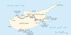
| Apraksts | Cyprus map from CIA World Factbook, converted from original GIF format |
| Datums | |
| Avots | CIA World Factbook: Cyprus. Archived from the original on 2003. gada 3. jūnijs. |
| Autors | United States Central Intelligence Agency |
| Citas versijas |
|
Licence
This image is in the public domain because it contains materials that originally came from the United States Central Intelligence Agency's World Factbook.
|
 |
Derivative works
-
 Cy-map-ger.png
Deutsch

-
 arābu
arābu

Faila hronoloģija
Uzklikšķini uz datums/laiks kolonnā esošās saites, lai apskatītos, kā šis fails izskatījās tad.
| Datums/Laiks | Attēls | Izmēri | Dalībnieks | Komentārs | |
|---|---|---|---|---|---|
| tagadējais | 2004. gada 27. novembris, plkst. 23.30 | | 629 × 319 (12 KB) | Kneiphof | CIA Cyprus map |
Faila lietojums
Šo failu izmanto šajā 1 lapā:
Globālais faila lietojums
Šīs Vikipēdijas izmanto šo failu:
- Izmantojums azb.wikipedia.org
- Izmantojums be.wikipedia.org
- Izmantojums ca.wikipedia.org
- Izmantojums ckb.wikipedia.org
- Izmantojums cs.wikinews.org
- Izmantojums de.wikipedia.org
- Izmantojums dsb.wikipedia.org
- Izmantojums en.wikipedia.org
- Cyprus
- Turkish invasion of Cyprus
- Greek junta
- Portal:Cyprus
- Greek New Zealanders
- United Nations Security Council Resolution 370
- United Nations Security Council Resolution 383
- United Nations Security Council Resolution 391
- United Nations Security Council Resolution 401
- United Nations Security Council Resolution 410
- United Nations Security Council Resolution 422
- United Nations Security Council Resolution 430
- United Nations Security Council Resolution 440
- United Nations Security Council Resolution 443
- Category:Populated places in Cyprus
- Talk:Grand Lodge of Cyprus
- Izmantojums en.wikivoyage.org
- Izmantojums eo.wikipedia.org
- Izmantojums fa.wikipedia.org
- Izmantojums fr.wikipedia.org
- Résolution 370 du Conseil de sécurité des Nations unies
- Résolution 383 du Conseil de sécurité des Nations unies
- Résolution 391 du Conseil de sécurité des Nations unies
- Résolution 401 du Conseil de sécurité des Nations unies
- Résolution 410 du Conseil de sécurité des Nations unies
- Résolution 422 du Conseil de sécurité des Nations unies
Skatīt šī faila pilno globālo izmantojumu.