Attēls:Claas Baseline HD.jpg

Šī priekšskata izmērs: 399 × 599 pikseļi. Citi izmēri: 160 × 240 pikseļi | 320 × 480 pikseļi | 512 × 768 pikseļi | 682 × 1 024 pikseļi | 1 333 × 2 000 pikseļi.
Sākotnējais fails (1 333 × 2 000 pikseļi, faila izmērs: 555 KB, MIME tips: image/jpeg)
| Šis fails ir no Vikikrātuves. Tā apraksts no attēla lapas Vikikrātuvē ir parādīts zemāk. Vikikrātuve ir brīvi licencēta failu krātuve. Tu vari tai palīdzēt. |
| Apraksts |
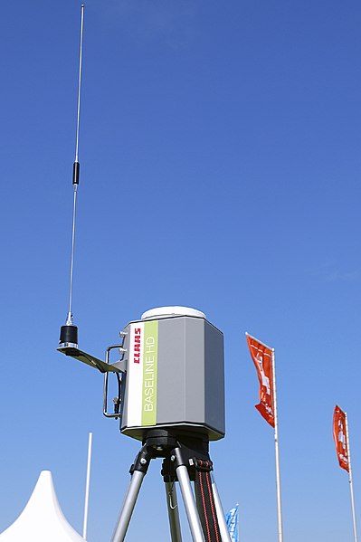
Deutsch: Mobile DGPS-Referenzstation Baseline HD von Claas für den Einsatz bei satellitengestützen Lenksystemen in der Landwirtschaft (Precision Farming); DLG-Feldtage 2010, Gut Bockerode, Springe-Mittelrode, Niedersachsen, Deutschland. – Die transportable Station ist mit einem Einfrequenz-GPS-Empfänger und GPS-Antenne sowie Funkgerät, Funkantenne und Batterie ausgestattet. Sie ermittelt ihre Position innerhalb weniger Minuten und sendet dann per Funk ein DGPS-Korrektursignal an die Landmaschinen auf dem Feld (Funkradius etwa 5 km, ohne dass Sichtkontakt nötig ist). Von den Lenksystemen (Claas GPS PILOT) der mit GPS- und Funk-Empfängern ausgestatteten Maschinen (z.B. Traktoren, Mähdrescher) werden die GPS-Satellitensignale mit dem lizenzfreien Korrektursignal kombiniert und in Lenkimpulse umgesetzt. Mit diesem Claas-System lässt sich eine GPS-Genauigkeit von 4–6 cm erreichen.
English: Mobile tripod-mounted DGPS reference station Baseline HD by Claas for use in satellite-assisted steering systems in agriculture (precision farming); DLG field days 2010, Gut Bockerode, Springe-Mittelrode, Lower Saxony, Germany. – The transportable station is equipped with a single-frequency GPS receiver and a GPS antenna, a radio and FM radio antenna, and a battery. It calculates its position within a few minutes and then sends a DGPS correction signal to on-field machines per radio (within a range of about 5 km, it does not rely on line-of-sight). The steering systems (Claas GPS PILOT) of the machines, that are equipped with GPS and radio receivers (e.g. tractors, combine harvesters), combine the GPS satellite signals with the licence-free DGPS correction signal, and convert them to steering impulses. This Claas system can provide a GPS accuracy of 4–6 cm. |
| Datums | |
| Avots | Paša darbs |
| Autors | bdk |
| Atļauja: (Šī faila izmantošana citur) |
bdk, šī darba autortiesību īpašnieks, publicē to saskaņā ar šo licenci: Šis fails tiek izplatīts saskaņā ar licences Creative Commons Atsauce-Līdzīgi Noteikumi 3.0 Vispārējiem noteikumiem. Atsauce: bdk
|
| Atsauce (required by the license) | © User:bdk / Wikimedia Commons / |
Faila hronoloģija
Uzklikšķini uz datums/laiks kolonnā esošās saites, lai apskatītos, kā šis fails izskatījās tad.
| Datums/Laiks | Attēls | Izmēri | Dalībnieks | Komentārs | |
|---|---|---|---|---|---|
| tagadējais | 2010. gada 21. jūnijs, plkst. 01.32 | | 1 333 × 2 000 (555 KB) | Bdk | {{Information |Description={{de|Mobile Referenzstation ''Baseline HD'' von Category:Claas für den Einsatz bei satellitengestützen Lenksystemen in der Landwirtschaft (''Precision Farming''); DLG-Feldtage 2010, Gut Bockerode, Springe-Mittelrode, Nie |
Faila lietojums
Šo failu izmanto šajā 1 lapā:
Globālais faila lietojums
Šīs Vikipēdijas izmanto šo failu:
- Izmantojums de.wikipedia.org
- Izmantojums en.wikipedia.org
- Izmantojums es.wikipedia.org
- Izmantojums fa.wikipedia.org
- Izmantojums he.wikipedia.org
- Izmantojums ja.wikipedia.org
- Izmantojums pt.wikipedia.org
- Izmantojums ru.wikipedia.org
- Izmantojums tr.wikipedia.org
- Izmantojums uk.wikipedia.org
- Izmantojums www.wikidata.org