Attēls:Chukotko-Kamchatkan map XVII-XX.png
Augstāka izšķirtspēja nav pieejama.
Chukotko-Kamchatkan_map_XVII-XX.png (450 × 500 pikseļi, faila izmērs: 35 KB, MIME tips: image/png)
| Šis fails ir no Vikikrātuves. Tā apraksts no attēla lapas Vikikrātuvē ir parādīts zemāk. Vikikrātuve ir brīvi licencēta failu krātuve. Tu vari tai palīdzēt. |

|
This linguistic map image could be re-created using vector graphics as an SVG file. This has several advantages; see Commons:Media for cleanup for more information. If an SVG form of this image is available, please upload it and afterwards replace this template with
{{vector version available|new image name}}.
It is recommended to name the SVG file “Chukotko-Kamchatkan map XVII-XX.svg”—then the template Vector version available (or Vva) does not need the new image name parameter. |
| Apraksts |
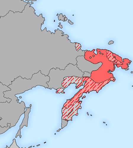
English: The map of distribution of Chukotko-Kamchatkan languages (red) in the XVII century (approximate; hatching) and in the end of XX century (continuous background). Русский: Карта распространения чукотско-камчатских языков (красный) в XVII веке (приблизительно; штриховка) и в конце XX века (сплошной фон). |
| Datums | |
| Avots |
background: File:Map of Russian subjects recent.png;
|
| Autors | Background map by user:fremantleboy, language map by Minami Himemiya |
| Atļauja: (Šī faila izmantošana citur) |
Šis fails tiek izplatīts saskaņā ar licences Creative Commons Atsauce 2.5 Vispārējiem noteikumiem.
|
Faila hronoloģija
Uzklikšķini uz datums/laiks kolonnā esošās saites, lai apskatītos, kā šis fails izskatījās tad.
| Datums/Laiks | Attēls | Izmēri | Dalībnieks | Komentārs | |
|---|---|---|---|---|---|
| tagadējais | 2009. gada 3. janvāris, plkst. 20.11 | | 450 × 500 (35 KB) | 姫宮南 | {{Information |Description={{en|The map of distribution of en:Chukotko-Kamchatkan languages (red) in the XVII century (approximate; hatching) and in the end of XX century (continuous background).}}{{ru|Карта распространения [[:ru |
Faila lietojums
Šo failu izmanto šajās 2 lapās:
Globālais faila lietojums
Šīs Vikipēdijas izmanto šo failu:
- Izmantojums ast.wikipedia.org
- Izmantojums az.wikipedia.org
- Izmantojums bat-smg.wikipedia.org
- Izmantojums cs.wikipedia.org
- Izmantojums de.wikipedia.org
- Izmantojums en.wikipedia.org
- Izmantojums es.wikipedia.org
- Izmantojums et.wikipedia.org
- Izmantojums fa.wikipedia.org
- Izmantojums fi.wikipedia.org
- Izmantojums hi.wikipedia.org
- Izmantojums hsb.wikipedia.org
- Izmantojums incubator.wikimedia.org
- Izmantojums ja.wikipedia.org
- Izmantojums lfn.wikipedia.org
- Izmantojums lij.wikipedia.org
- Izmantojums lt.wikipedia.org
- Izmantojums mk.wikipedia.org
- Izmantojums nl.wikipedia.org
- Izmantojums nl.wiktionary.org
- Izmantojums nn.wikipedia.org
- Izmantojums ru.wikipedia.org
- Izmantojums sh.wikipedia.org
- Izmantojums sr.wikipedia.org
- Izmantojums sv.wikipedia.org
- Izmantojums tr.wikipedia.org
- Izmantojums uk.wikipedia.org
- Izmantojums vep.wikipedia.org
- Izmantojums vi.wikipedia.org
- Izmantojums zh.wikipedia.org