Attēls:Andulinang Island.jpg

Sākotnējais fails (4 032 × 3 024 pikseļi, faila izmērs: 3,06 MB, MIME tips: image/jpeg)
| Šis fails ir no Vikikrātuves. Tā apraksts no attēla lapas Vikikrātuvē ir parādīts zemāk. Vikikrātuve ir brīvi licencēta failu krātuve. Tu vari tai palīdzēt. |
Kopsavilkums
| Apraksts |
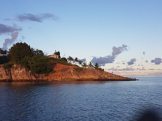
English: Andulinang Island during sunset. A 2-hectare island and is the largest of two islands in the Andulinang Reef of Celebes Sea. Taken during the mapping, reconnaissance, extraction-deployment mission of the Philippine Marines together with Schadow1 Expeditions. |
||
| Datums | |||
| Avots | Paša darbs | ||
| Autors | Ervin Malicdem | ||
| Atļauja: (Šī faila izmantošana citur) |
This file is licensed under the Creative Commons Attribution-Share Alike 4.0 International license.
|

| Camera location | | View this and other nearby images on: OpenStreetMap |
|---|
Initially published at Schadow1 Expeditions article available at http://www.s1expeditions.com/2017/06/213-tawi-tawi-mapping-expedition.html
Licence
- Jūs varat brīvi:
- koplietot – kopēt, izplatīt un pārraidīt darbu
- remiksēt – pielāgot darbu
- Saskaņā ar šādiem nosacījumiem:
- atsaucoties – Tev ir jānorāda autors, saite uz licenci un to, vai veiktas kādas izmaiņas. To var darīt jebkādā saprātīgā veidā, bet ne tādā, kas norādītu, ka licencētājs atbalsta tevi vai veidu, kā tu izmanto šo darbu.
- nemainot licenci – Ja tu miksē, pārveido vai izmanto materiālu, tev savs devums jāpublicē ar to pašu vai saderīgu licenci kā oriģināls.
Faila hronoloģija
Uzklikšķini uz datums/laiks kolonnā esošās saites, lai apskatītos, kā šis fails izskatījās tad.
| Datums/Laiks | Attēls | Izmēri | Dalībnieks | Komentārs | |
|---|---|---|---|---|---|
| tagadējais | 2017. gada 27. jūnijs, plkst. 07.36 | | 4 032 × 3 024 (3,06 MB) | Schadow1 | User created page with UploadWizard |
Faila lietojums
Šo failu izmanto šajā 1 lapā:
Globālais faila lietojums
Šīs Vikipēdijas izmanto šo failu:
- Izmantojums ceb.wikipedia.org
- Izmantojums en.wikipedia.org
- Izmantojums www.wikidata.org