Attēls:Zandvoort.svg

Size of this PNG preview of this SVG file: 716 × 600 pikseļi. Citi izmēri: 287 × 240 pikseļi | 573 × 480 pikseļi | 917 × 768 pikseļi | 1 222 × 1 024 pikseļi | 2 445 × 2 048 pikseļi | 1 042 × 873 pikseļi.
Sākotnējais fails (SVG fails, definētais izmērs 1 042 × 873 pikseļi, faila izmērs: 50 KB)
| Šis fails ir no Vikikrātuves. Tā apraksts no attēla lapas Vikikrātuvē ir parādīts zemāk. Vikikrātuve ir brīvi licencēta failu krātuve. Tu vari tai palīdzēt. |
Kopsavilkums
| Apraksts |
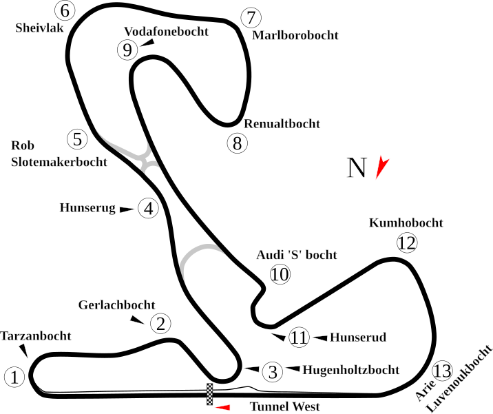
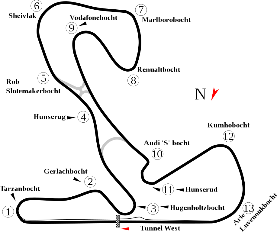
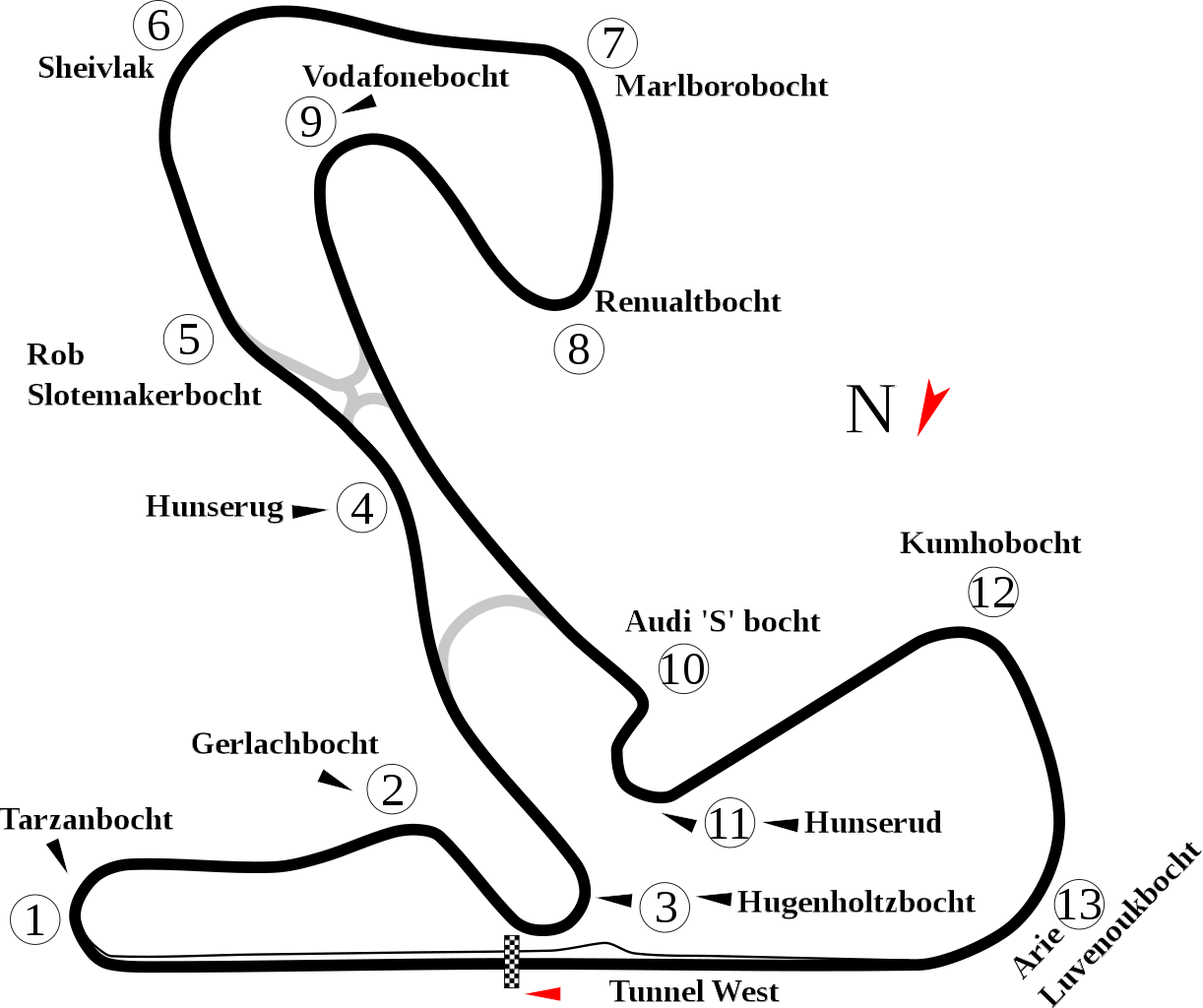
English: Track map for Circuit Park Zandvoort. |
| Datums | |
| Avots | Paša darbs |
| Autors | Will Pittenger |
| Citas versijas |
|

| Camera location | | View this and other nearby images on: OpenStreetMap |
|---|
Licence
| I, the copyright holder of this work, release this work into the public domain. This applies worldwide. In some countries this may not be legally possible; if so: I grant anyone the right to use this work for any purpose, without any conditions, unless such conditions are required by law. |
Faila hronoloģija
Uzklikšķini uz datums/laiks kolonnā esošās saites, lai apskatītos, kā šis fails izskatījās tad.
| Datums/Laiks | Attēls | Izmēri | Dalībnieks | Komentārs | |
|---|---|---|---|---|---|
| tagadējais | 2011. gada 14. augusts, plkst. 22.01 | | 1 042 × 873 (50 KB) | Sentoan | Actual usually track |
| 2008. gada 18. jūlijs, plkst. 09.34 |  | 1 042 × 873 (49 KB) | Will Pittenger | {{Information |Description={{en|1=Track map for w:Circuit Park Zandvoort.}} |Source=Own work by uploader |Author=Will Pittenger |Date=7-18-2008 |Permission= |other_versions=<gallery>Image:Circuit Zandvoort.png|Old image &mdash |
Faila lietojums
Šo failu izmanto šajā 1 lapā:
Globālais faila lietojums
Šīs Vikipēdijas izmanto šo failu:
- Izmantojums ast.wikipedia.org
- Izmantojums cs.wikipedia.org
- Izmantojums en.wikipedia.org
- Masters of Formula 3
- 2006–07 A1 Grand Prix of Nations, Netherlands
- List of A1 Grand Prix circuits
- 2007–08 A1 Grand Prix of Nations, Netherlands
- User talk:Chubbennaitor/archive2
- User talk:Barkjon/Archive 2
- Wikipedia:WikiProject Formula One/Newsletter/200808
- User talk:Hellboy2hell/archive2
- User talk:NapHit/Archive 1
- 2008–09 A1 Grand Prix of Nations, Netherlands
- User talk:4u1e/archive5
- User talk:Typ932/Archive 3
- User talk:Midgrid/Archive 6
- User talk:Thelb4/Archive 5
- User talk:Chubbennaitor/Archive7
- User talk:Readro/Archive 3
- User talk:Donnie Park/Archive 1
- User talk:The359/Archive 4
- FIA WTCR Race of the Netherlands
- 2009 Masters of Formula 3
- User talk:Cs-wolves/Archive 3
- 1999 Masters of Formula 3
- 2000 Masters of Formula 3
- 2001 Masters of Formula 3
- 2002 Masters of Formula 3
- 2003 Masters of Formula 3
- 2004 Masters of Formula 3
- 2005 Masters of Formula 3
- 2006 Masters of Formula 3
- 2010 Masters of Formula 3
- User talk:Bam123456789/Archive 1
- 2011 Masters of Formula 3
- 2012 Masters of Formula 3
- User talk:Sage Callahan/Archive 1
- User talk:Cdhaptomos/Archive 1
- 2013 Masters of Formula 3
- 2014 Zandvoort Masters
- 2015 Masters of Formula 3
- 2015 Blancpain Sprint Series Zandvoort round
- User talk:Spenalzo/Archive/2008
- User talk:Clyde1998/Archive/2008
- 2016 Masters of Formula 3
- List of FIA World Touring Car Championship circuits
- Izmantojums es.wikipedia.org
- Izmantojums fi.wikipedia.org
Skatīt šī faila pilno globālo izmantojumu.