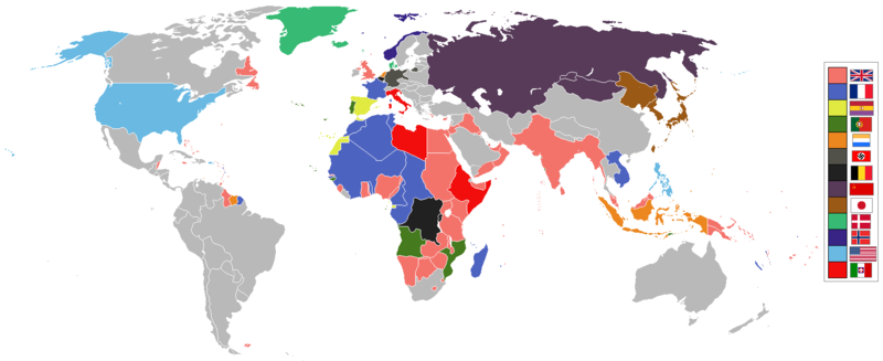
Attēls:World 1936 empires colonies territory.png

Sākotnējais fails (1 527 × 624 pikseļi, faila izmērs: 44 KB, MIME tips: image/png)
| Šis fails ir no Vikikrātuves. Tā apraksts no attēla lapas Vikikrātuvē ir parādīts zemāk. Vikikrātuve ir brīvi licencēta failu krātuve. Tu vari tai palīdzēt. |
1936 coolio stuff
Kopsavilkums
العربية
English
മലയാളം
Deutsch
한국어
Українська
简体中文
繁體中文

|
This historical map image could be re-created using vector graphics as an SVG file. This has several advantages; see Commons:Media for cleanup for more information. If an SVG form of this image is available, please upload it and afterwards replace this template with
{{vector version available|new image name}}.
It is recommended to name the SVG file “World 1936 empires colonies territory.svg”—then the template Vector version available (or Vva) does not need the new image name parameter. |

|
Legal disclaimer This image contains a symbol prohibited by law in some nations, owing to it being a representation of communism, socialism, or a similar governmental structure; or of an associated political party/organization:
Imagery covered may include the hammer and sickleen, red star, emblems/insignias, flags or images of leaders. |

|
Legal disclaimer This image shows (or resembles) a symbol that was used by the National Socialist (NSDAP/Nazi) government of Germany or an organization closely associated to it, or another party which has been banned by the Federal Constitutional Court of Germany. The use of insignia of organizations that have been banned in Germany (like the Nazi swastika or the arrow cross) may also be illegal in Austria, Hungary, Poland, Czech Republic, France, Brazil, Israel, Ukraine, Russia and other countries, depending on context. In Germany, the applicable law is paragraph 86a of the criminal code (StGB), in Poland – Art. 256 of the criminal code (Dz.U. 1997 nr 88 poz. 553). |
See also
| Maps of world history | |
| BC | |
|
| |
| AD |
1 · 50 · 100 · 200 · 250 · 300 · 400 · 500 · 700 · 750 · 820 · 900 · 1200 · 1500 · 1556 · 1648 · 1700 · 1750 · 1815 · 1859 · 1871 · 1914 · 1989 · 2000 · |
|
Maps of colonization history | |
|
see also: Eastern Hemisphere only maps template (1300BC-1500AD) | |
| (this template: · view · discuss ) | |
.jpg)
._LOC_2001620596.jpg)
Licence

|
Ir dota atļauja kopēt, izplatīt un/vai pārveidot šo dokumentu saskaņā ar GNU brīvās dokumentācijas licences, versijas 1.2 vai jebkuras vēlākas versijas, ko publiskojis Brīvās programmatūras fonds nosacījumiem; bez nemainīgajām sadaļā, priekšējā un aizmugurēja'vāka tekstiem. Licences kopija ir iekļauta sadaļā ar nosaukumu GNU brīvās dokumentācijas licence. |
| Šis fails tiek izplatīts saskaņā ar licences Creative Commons Atsauce-Līdzīgi Noteikumi 3.0 Vispārējiem noteikumiem. | ||
| ||
| This licensing tag was added to this file as part of the GFDL licensing update. |
Faila hronoloģija
Uzklikšķini uz datums/laiks kolonnā esošās saites, lai apskatītos, kā šis fails izskatījās tad.
| Datums/Laiks | Attēls | Izmēri | Dalībnieks | Komentārs | |
|---|---|---|---|---|---|
| tagadējais | 2020. gada 6. maijs, plkst. 16.41 | 1 527 × 624 (44 KB) | The- | The Dominions should not be shaded in British Empire colour post-1931 Statute of Westmisnter. They had independent foreign policies and were no longer under British control in any way, shape or form. | |
| 2019. gada 12. maijs, plkst. 15.34 | 1 527 × 624 (44 KB) | The- | If there are some problems with the accurate map, fix the accurate map, don't revert back to the old inaccurate map! | ||
| 2018. gada 12. septembris, plkst. 10.34 |  | 1 458 × 627 (33 KB) | Oleksiy.golubov | Reverted to version as of 13:34, 29 July 2012 (UTC): no reason to indicate Turkey and China; colors of Belgium and the Netherlands were wrong. | |
| 2018. gada 20. jūlijs, plkst. 22.51 | 1 527 × 624 (3,64 MB) | SuperSucker | oops forgot Germany had Nazi flag in 1936 | ||
| 2018. gada 20. jūlijs, plkst. 22.39 | 1 527 × 624 (3,64 MB) | SuperSucker | fix - added Turkey (it existed as Turkey in 1936) and China; changed China's flag as they had it changed by 1930 | ||
| 2016. gada 20. augusts, plkst. 17.47 | 1 527 × 624 (44 KB) | The- | Some fixes | ||
| 2016. gada 17. aprīlis, plkst. 23.29 | 1 527 × 624 (44 KB) | The- | More accurate map | ||
| 2012. gada 29. jūlijs, plkst. 16.34 |  | 1 458 × 627 (33 KB) | Faunas | Reverted to version as of 13:31, 29 July 2012 | |
| 2012. gada 29. jūlijs, plkst. 16.33 |  | 1 458 × 627 (33 KB) | Faunas | In the previous version, São Tomé e Príncipe was indicated as a Spanish colony; I changed it to indicate it was a Portuguese colony (which it was). | |
| 2012. gada 29. jūlijs, plkst. 16.31 |  | 1 458 × 627 (33 KB) | Faunas | In the previous version, São Tomé e Príncipe was indicated as a Spanish colony; I changed it to indicate it was a Portuguese colony (which it was). |
Faila lietojums
Šo failu izmanto šajā 1 lapā:
Globālais faila lietojums
Šīs Vikipēdijas izmanto šo failu:
- Izmantojums af.wikipedia.org
- Izmantojums am.wikipedia.org
- Izmantojums ar.wikipedia.org
- Izmantojums arz.wikipedia.org
- Izmantojums az.wikipedia.org
- Izmantojums bn.wikipedia.org
- Izmantojums bs.wikipedia.org
- Izmantojums de.wikipedia.org
- Izmantojums en.wikipedia.org
- Izmantojums fa.wikipedia.org
- Izmantojums fr.wikipedia.org
- Izmantojums ja.wikipedia.org
- Izmantojums li.wikipedia.org
- Izmantojums mg.wikipedia.org
- Izmantojums ms.wikipedia.org
- Izmantojums nl.wikipedia.org
- Izmantojums pt.wikipedia.org
- Izmantojums sr.wikipedia.org
- Izmantojums th.wikipedia.org
- Izmantojums uk.wikipedia.org
- Izmantojums www.wikidata.org