Attēls:Western Germany 1923 en.png

Šī priekšskata izmērs: 370 × 599 pikseļi. Citi izmēri: 148 × 240 pikseļi | 296 × 480 pikseļi | 474 × 768 pikseļi | 632 × 1 024 pikseļi | 1 406 × 2 276 pikseļi.
Sākotnējais fails (1 406 × 2 276 pikseļi, faila izmērs: 2,95 MB, MIME tips: image/png)
| Šis fails ir no Vikikrātuves. Tā apraksts no attēla lapas Vikikrātuvē ir parādīts zemāk. Vikikrātuve ir brīvi licencēta failu krātuve. Tu vari tai palīdzēt. |
Kopsavilkums
| Apraksts |
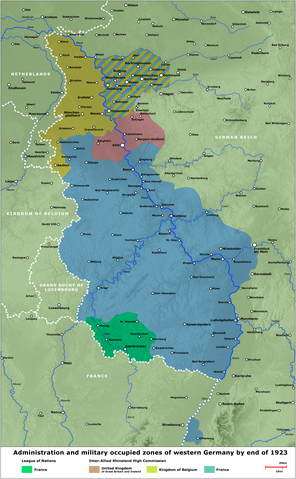
English: Map - Administration and military occupied zones of western Germany by end of 1923
Deutsch: Karte - Verwaltung bzw. Besatzung der westdeutschen Gebiete, Ende 1923 |
| Datums | |
| Avots | several contemporary illustrations/verschiedene zeitgenössische Darstellungen |
| Autors | Lothar Velling, Relief: maps-for-free.com |
| Citas versijas | German Version, Arabic Version |
Licence
| I, the copyright holder of this work, release this work into the public domain. This applies worldwide. In some countries this may not be legally possible; if so: I grant anyone the right to use this work for any purpose, without any conditions, unless such conditions are required by law. |
Faila hronoloģija
Uzklikšķini uz datums/laiks kolonnā esošās saites, lai apskatītos, kā šis fails izskatījās tad.
| Datums/Laiks | Attēls | Izmēri | Dalībnieks | Komentārs | |
|---|---|---|---|---|---|
| tagadējais | 2020. gada 24. septembris, plkst. 22.26 | | 1 406 × 2 276 (2,95 MB) | JuTa | Please upload it to a different filename |
| 2020. gada 17. septembris, plkst. 02.28 |  | 600 × 1 196 (834 KB) | Jordi | Reverted to version as of 08:50, 18 May 2020 (UTC), reason for substitution was explained here | |
| 2020. gada 23. maijs, plkst. 13.06 |  | 1 406 × 2 276 (2,95 MB) | JuTa | The other one is available at File:Western Germany 1923 de.png | |
| 2020. gada 18. maijs, plkst. 11.50 |  | 600 × 1 196 (834 KB) | Jordi | Same procedure as [https://commons.wikimedia.org/w/index.php?title=File:Western_Germany_1923_de.png&diff=prev&oldid=419997923 here] | |
| 2009. gada 2. jūlijs, plkst. 13.17 |  | 1 406 × 2 276 (2,95 MB) | SuCapitanidad | Correction Mannheim and Ludwigshafen | |
| 2008. gada 2. augusts, plkst. 19.49 |  | 1 405 × 2 273 (3,08 MB) | SuCapitanidad | {{Information |Description= |Source= |Date= |Author= |Permission= |other_versions= }} | |
| 2008. gada 11. jūnijs, plkst. 02.42 |  | 1 405 × 2 273 (3,06 MB) | SuCapitanidad | {{Information |Description={{en|1=Map - Administration and military occupied zones of western Germany by end of 1923}} {{de|1=Karte - Verwaltung bzw. Besatzung der westdeutschen Gebiete, Ende 1923}} |Source=several contemporary illustrations/verschiedene |
Faila lietojums
Šo failu izmanto šajā 1 lapā:
Globālais faila lietojums
Šīs Vikipēdijas izmanto šo failu:
- Izmantojums ar.wikipedia.org
- Izmantojums az.wikipedia.org
- Izmantojums ca.wikipedia.org
- Izmantojums cs.wikipedia.org
- Izmantojums en.wikipedia.org
- Izmantojums es.wikipedia.org
- Izmantojums fa.wikipedia.org
- Izmantojums fi.wikipedia.org
- Izmantojums fr.wikipedia.org
- Izmantojums he.wikipedia.org
- Izmantojums it.wikipedia.org
- Izmantojums ko.wikipedia.org
- Izmantojums pl.wikipedia.org
- Izmantojums pt.wikipedia.org
- Izmantojums ro.wikipedia.org
- Izmantojums ru.wikipedia.org
- Izmantojums th.wikipedia.org
- Izmantojums uk.wikipedia.org
- Izmantojums zh.wikipedia.org