Attēls:Wales Monmouthshire locator map.svg

Size of this PNG preview of this SVG file: 502 × 600 pikseļi. Citi izmēri: 201 × 240 pikseļi | 402 × 480 pikseļi | 643 × 768 pikseļi | 857 × 1 024 pikseļi | 1 714 × 2 048 pikseļi | 1 047 × 1 251 pikseļi.
Sākotnējais fails (SVG fails, definētais izmērs 1 047 × 1 251 pikseļi, faila izmērs: 149 KB)
| Šis fails ir no Vikikrātuves. Tā apraksts no attēla lapas Vikikrātuvē ir parādīts zemāk. Vikikrātuve ir brīvi licencēta failu krātuve. Tu vari tai palīdzēt. |
Kopsavilkums
| Apraksts |
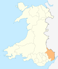
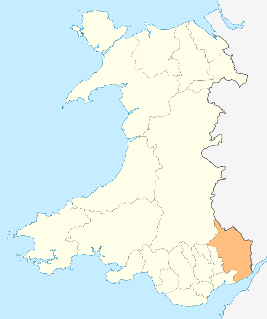
Deutsch: Lagekarte von Monmouthshire in Wales
English: Locator map of Monmouthshire in Wales |
| Datums | |
| Avots | Paša darbs |
| Autors | NordNordWest |
| Atļauja: (Šī faila izmantošana citur) |
Es, šī darba autortiesību īpašnieks, publicēju to saskaņā ar šo licenci: Šis fails tiek izplatīts saskaņā ar licences Creative Commons Atsauce-Līdzīgi Noteikumi 3.0 Vispārējiem noteikumiem.
|

|
Šī karte bija uzlabota vācu Kartenwerkstatt. Jūs arī varat piedāvāt citas kartes uzlabošanai.
|
Faila hronoloģija
Uzklikšķini uz datums/laiks kolonnā esošās saites, lai apskatītos, kā šis fails izskatījās tad.
| Datums/Laiks | Attēls | Izmēri | Dalībnieks | Komentārs | |
|---|---|---|---|---|---|
| tagadējais | 2010. gada 4. maijs, plkst. 21.54 | | 1 047 × 1 251 (149 KB) | NordNordWest | {{int:filedesc}} {{Information |Description= {{de|Lagekarte von Monmouthshire in Wales}} {{en|Locator map of Monmouthshire in Wales}} |Source={{Own}} |Date=2010-05-04 |Author={{U|NordNordWest}} |Permission={{self|cc-by-sa-3.0}} |other_versions= }} {{Kart |
Faila lietojums
Šo failu izmanto šajā 1 lapā:
Globālais faila lietojums
Šīs Vikipēdijas izmanto šo failu:
- Izmantojums cs.wikipedia.org
- Izmantojums en.wikipedia.org
- Abergavenny
- Monmouth
- Usk
- Chepstow
- Monmouthshire
- Caldicot
- Caerwent
- Llanelly
- Rogiet
- List of places in Monmouthshire
- Little Mill, Monmouthshire
- Template:Monmouthshire-geo-stub
- Llanbadoc
- Wye Valley
- River Trothy
- Llanarth, Monmouthshire
- Grosmont, Monmouthshire
- Graig Syfyrddin
- Monnow Valley Walk
- Tregare
- Blaina
- Llanddewi Rhydderch
- Ashvale, Blaenau Gwent
- Govilon
- Llantilio Pertholey
- Llanvihangel Gobion
- Llangattock Lingoed
- Llanvihangel-Ystern-Llewern
- Cross Ash
- Bryngwyn
- Cwmcarvan
- Mitchel Troy
- Newbridge-on-Usk
- Mardy, Monmouthshire
- Wolvesnewton
- Llanover
- Llancayo
- Llandenny
- Llanvetherine
- Mamhilad
- Oldcastle, Monmouthshire
- Llantrisant, Monmouthshire
- Llanwenarth
- St. Arvans
- Catbrook
- Glascoed
- Llansoy
- St. Maughans
- Monkswood, Monmouthshire
Skatīt šī faila pilno globālo izmantojumu.