Attēls:Via Appia map.jpg

Šī priekšskata izmērs: 800 × 433 pikseļi. Citi izmēri: 320 × 173 pikseļi | 640 × 346 pikseļi | 1 280 × 692 pikseļi.
Sākotnējais fails (1 280 × 692 pikseļi, faila izmērs: 599 KB, MIME tips: image/jpeg)
| Šis fails ir no Vikikrātuves. Tā apraksts no attēla lapas Vikikrātuvē ir parādīts zemāk. Vikikrātuve ir brīvi licencēta failu krātuve. Tu vari tai palīdzēt. |

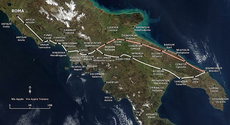
English: Map of the Appian Way and the later and shorter Via Appia Traiana.
Deutsch: Karte der Via Appia und der Via Appia Traiana.
Kopsavilkums
This map is based on the following picture: Image:Satellite image of Italy in March 2003.jpg
Licence
| I, the copyright holder of this work, release this work into the public domain. This applies worldwide. In some countries this may not be legally possible; if so: I grant anyone the right to use this work for any purpose, without any conditions, unless such conditions are required by law. |
| This file is in the public domain in the United States because it was solely created by NASA. NASA copyright policy states that "NASA material is not protected by copyright unless noted". (See Template:PD-USGov, NASA copyright policy page or JPL Image Use Policy.) | ||
 |
Warnings:
|
Faila hronoloģija
Uzklikšķini uz datums/laiks kolonnā esošās saites, lai apskatītos, kā šis fails izskatījās tad.
| Datums/Laiks | Attēls | Izmēri | Dalībnieks | Komentārs | |
|---|---|---|---|---|---|
| tagadējais | 2009. gada 9. novembris, plkst. 20.19 | | 1 280 × 692 (599 KB) | AlMare | Mondragone |
| 2009. gada 27. jūlijs, plkst. 19.22 |  | 1 280 × 692 (602 KB) | AlMare | +Aequum Tuticum | |
| 2009. gada 14. februāris, plkst. 21.02 |  | 1 280 × 692 (538 KB) | AlMare | Reverted to version as of 17:31, 13 July 2006 | |
| 2008. gada 2. decembris, plkst. 00.03 |  | 1 280 × 692 (603 KB) | AlMare | +Sessa Aurunca | |
| 2006. gada 13. jūlijs, plkst. 20.31 |  | 1 280 × 692 (538 KB) | AlMare | == Summary == This map is based on the following picture: Image:Satellite image of Italy in March 2003.jpg == Licensing == {{PD-self}} | |
| 2006. gada 13. jūlijs, plkst. 20.26 |  | 1 000 × 433 (357 KB) | AlMare | This map is based on the following picture: Image:Satellite image of Italy in March 2003.jpg) |
&action=edit&redlink=1)
Faila lietojums
Šo failu izmanto šajā 1 lapā:
Globālais faila lietojums
Šīs Vikipēdijas izmanto šo failu:
- Izmantojums af.wikipedia.org
- Izmantojums ar.wikipedia.org
- Izmantojums azb.wikipedia.org
- Izmantojums be.wikipedia.org
- Izmantojums bg.wikipedia.org
- Izmantojums bn.wikipedia.org
- Izmantojums ca.wikipedia.org
- Izmantojums cs.wikipedia.org
- Izmantojums de.wikipedia.org
- Izmantojums el.wikipedia.org
- Izmantojums en.wikipedia.org
- Izmantojums en.wikivoyage.org
- Izmantojums eo.wikipedia.org
- Izmantojums es.wikipedia.org
- Izmantojums et.wikipedia.org
- Izmantojums fr.wikipedia.org
- Izmantojums he.wikipedia.org
- Izmantojums hr.wikipedia.org
- Izmantojums hu.wikipedia.org
- Izmantojums id.wikipedia.org
- Izmantojums it.wikipedia.org
Skatīt šī faila pilno globālo izmantojumu.