Attēls:Vanuatu Provinces.JPG
Šī priekšskata izmērs: 549 × 599 pikseļi. Citi izmēri: 220 × 240 pikseļi | 558 × 609 pikseļi.
Sākotnējais fails (558 × 609 pikseļi, faila izmērs: 36 KB, MIME tips: image/jpeg)
| Šis fails ir no Vikikrātuves. Tā apraksts no attēla lapas Vikikrātuvē ir parādīts zemāk. Vikikrātuve ir brīvi licencēta failu krātuve. Tu vari tai palīdzēt. |
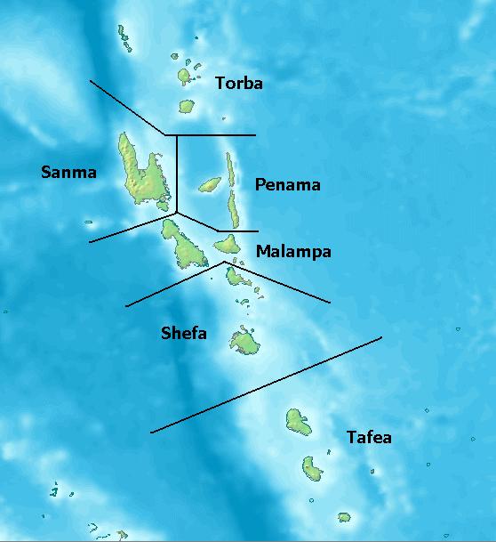
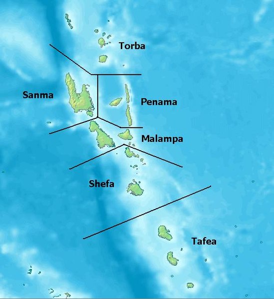
Map of Provinces of Vanuatu. Created with DEMIS World Map Server[dead link]
License: http://www2.demis.nl/mapserver/DataSrc.htm archive copy at the Wayback Machine
| This work has been released into the public domain by its author, DEMIS BV. This applies worldwide. In some countries this may not be legally possible; if so: DEMIS BV grants anyone the right to use this work for any purpose, without any conditions, unless such conditions are required by law.
|
Faila hronoloģija
Uzklikšķini uz datums/laiks kolonnā esošās saites, lai apskatītos, kā šis fails izskatījās tad.
| Datums/Laiks | Attēls | Izmēri | Dalībnieks | Komentārs | |
|---|---|---|---|---|---|
| tagadējais | 2005. gada 25. jūlijs, plkst. 03.10 | | 558 × 609 (36 KB) | Taichi | Map of Provinces of Vanuatu. Created with [ http://www2.demis.nl/mapserver/mapper.asp DEMIS World Map Server] License: http://www2.demis.nl/mapserver/DataSrc.htm {{PD}} Category:Maps |
Faila lietojums
Šo failu izmanto šajā 1 lapā:
Globālais faila lietojums
Šīs Vikipēdijas izmanto šo failu:
- Izmantojums als.wikipedia.org
- Izmantojums arz.wikipedia.org
- Izmantojums az.wikipedia.org
- Izmantojums bi.wikipedia.org
- Izmantojums bjn.wikipedia.org
- Izmantojums ceb.wikipedia.org
- Izmantojums cs.wikipedia.org
- Izmantojums da.wikipedia.org
- Izmantojums de.wikipedia.org
- Izmantojums el.wikipedia.org
- Izmantojums en.wikipedia.org
- Izmantojums eo.wikipedia.org
- Izmantojums es.wikipedia.org
- Izmantojums et.wikipedia.org
- Izmantojums eu.wikipedia.org
- Izmantojums fi.wikipedia.org
- Izmantojums fi.wiktionary.org
- Izmantojums frr.wikipedia.org
- Izmantojums fr.wikipedia.org
- Izmantojums fr.wiktionary.org
- Izmantojums gl.wikipedia.org
- Izmantojums hi.wikipedia.org
- Izmantojums hr.wikipedia.org
Skatīt šī faila pilno globālo izmantojumu.