Attēls:United Kingdom EU referendum 2016 area results 2-tone.svg

Size of this PNG preview of this SVG file: 405 × 599 pikseļi. Citi izmēri: 162 × 240 pikseļi | 324 × 480 pikseļi | 519 × 768 pikseļi | 692 × 1 024 pikseļi | 1 384 × 2 048 pikseļi | 871 × 1 289 pikseļi.
Sākotnējais fails (SVG fails, definētais izmērs 871 × 1 289 pikseļi, faila izmērs: 4,66 MB)
| Šis fails ir no Vikikrātuves. Tā apraksts no attēla lapas Vikikrātuvē ir parādīts zemāk. Vikikrātuve ir brīvi licencēta failu krātuve. Tu vari tai palīdzēt. |
Kopsavilkums
| Apraksts |
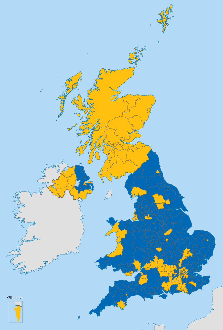
English (en): Map of the United Kingdom showing the voting areas for the European Union membership referendum, 2016.
Leave Remain
|
| Datums | |
| Avots |
This vector image includes elements that have been taken or adapted from this file: This vector image includes elements that have been taken or adapted from this file: This vector image includes elements that have been taken or adapted from this file: This vector image includes elements that have been taken or adapted from this file: This vector image includes elements that have been taken or adapted from this file: |
| Autors |
Mirrorme22 Nilfanion: English and Scottish council areas TUBS: Welsh council areas Sting: Gibraltar |
| Citas versijas |
 |
| SVG veidošana |
Licence
Šis fails tiek izplatīts saskaņā ar licences Creative Commons Atsauce-Līdzīgi Noteikumi 3.0 Vispārējiem noteikumiem.
- Jūs varat brīvi:
- koplietot – kopēt, izplatīt un pārraidīt darbu
- remiksēt – pielāgot darbu
- Saskaņā ar šādiem nosacījumiem:
- atsaucoties – Tev ir jānorāda autors, saite uz licenci un to, vai veiktas kādas izmaiņas. To var darīt jebkādā saprātīgā veidā, bet ne tādā, kas norādītu, ka licencētājs atbalsta tevi vai veidu, kā tu izmanto šo darbu.
- nemainot licenci – Ja tu miksē, pārveido vai izmanto materiālu, tev savs devums jāpublicē ar to pašu vai saderīgu licenci kā oriģināls.
Faila hronoloģija
Uzklikšķini uz datums/laiks kolonnā esošās saites, lai apskatītos, kā šis fails izskatījās tad.
| Datums/Laiks | Attēls | Izmēri | Dalībnieks | Komentārs | |
|---|---|---|---|---|---|
| tagadējais | 2016. gada 25. jūlijs, plkst. 23.09 | | 871 × 1 289 (4,66 MB) | Cranberry Products | fixed Horsham and Havant |
| 2016. gada 24. jūnijs, plkst. 22.06 |  | 871 × 1 289 (4,66 MB) | Nilfanion | Reverted, dark boundary lines please - white is jarring | |
| 2016. gada 24. jūnijs, plkst. 22.04 |  | 871 × 1 289 (4,66 MB) | EmmaCoop | Wrong upload | |
| 2016. gada 24. jūnijs, plkst. 20.54 |  | 871 × 1 289 (4,66 MB) | EmmaCoop | Set boundaries to #fff | |
| 2016. gada 24. jūnijs, plkst. 12.08 |  | 871 × 1 289 (4,66 MB) | Nilfanion | fix Carms | |
| 2016. gada 24. jūnijs, plkst. 10.42 |  | 871 × 1 289 (4,66 MB) | Nilfanion | full results | |
| 2016. gada 24. jūnijs, plkst. 04.13 |  | 871 × 1 289 (4,66 MB) | Nilfanion | =={{int:filedesc}}== {{Information |description={{en|1=Map of the United Kingdom showing the voting areas for the European Union membership referendum, 2016.}} |date=2016-02-20 |source={{AttribSVG|Scottish council areas 2011.svg|Nilfanion}}{{AttribSVG|... |
Faila lietojums
Šo failu izmanto šajā 1 lapā:
Globālais faila lietojums
Šīs Vikipēdijas izmanto šo failu:
- Izmantojums als.wikipedia.org
- Izmantojums an.wikipedia.org
- Izmantojums ast.wikipedia.org
- Izmantojums bat-smg.wikipedia.org
- Izmantojums br.wikipedia.org
- Izmantojums ca.wikipedia.org
- Izmantojums ckb.wikipedia.org
- Izmantojums cy.wikipedia.org
- Izmantojums da.wikipedia.org
- Izmantojums de.wikipedia.org
- Izmantojums el.wikipedia.org
- Izmantojums eml.wikipedia.org
- Izmantojums en.wikipedia.org
- Referendums in the United Kingdom
- Political history of the United Kingdom (1979–present)
- 2016 United Kingdom European Union membership referendum
- Brexit
- European Union Referendum Act 2015
- Results of the 2016 United Kingdom European Union membership referendum
- Wikipedia:In the news/Candidates/June 2016
- Talk:2016 United Kingdom European Union membership referendum/Archive 2
- Template:UKEU2016Results
- Talk:2016 United Kingdom European Union membership referendum/Archive 3
- Aftermath of the 2016 United Kingdom European Union membership referendum
- United Kingdom membership of the European Union
- Izmantojums eo.wikipedia.org
- Izmantojums es.wikipedia.org
- Izmantojums et.wikipedia.org
- Izmantojums eu.wikipedia.org
- Izmantojums fi.wikipedia.org
- Izmantojums fr.wikipedia.org
- Izmantojums gl.wikipedia.org
- Izmantojums id.wikipedia.org
- Izmantojums it.wikipedia.org
- Izmantojums jv.wikipedia.org
- Izmantojums ko.wikipedia.org
Skatīt šī faila pilno globālo izmantojumu.