Attēls:Satellite image of Denmark in July 2001.jpg

Šī priekšskata izmērs: 800 × 596 pikseļi. Citi izmēri: 320 × 239 pikseļi | 640 × 477 pikseļi | 1 024 × 763 pikseļi | 1 280 × 954 pikseļi | 1 905 × 1 420 pikseļi.
Sākotnējais fails (1 905 × 1 420 pikseļi, faila izmērs: 190 KB, MIME tips: image/jpeg)
| Šis fails ir no Vikikrātuves. Tā apraksts no attēla lapas Vikikrātuvē ir parādīts zemāk. Vikikrātuve ir brīvi licencēta failu krātuve. Tu vari tai palīdzēt. |
| This file is in the public domain in the United States because it was solely created by NASA. NASA copyright policy states that "NASA material is not protected by copyright unless noted". (See Template:PD-USGov, NASA copyright policy page or JPL Image Use Policy.) | ||
 |
Warnings:
|
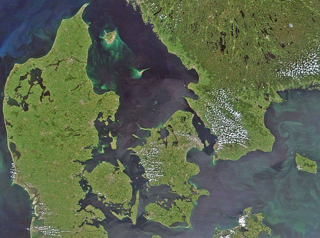
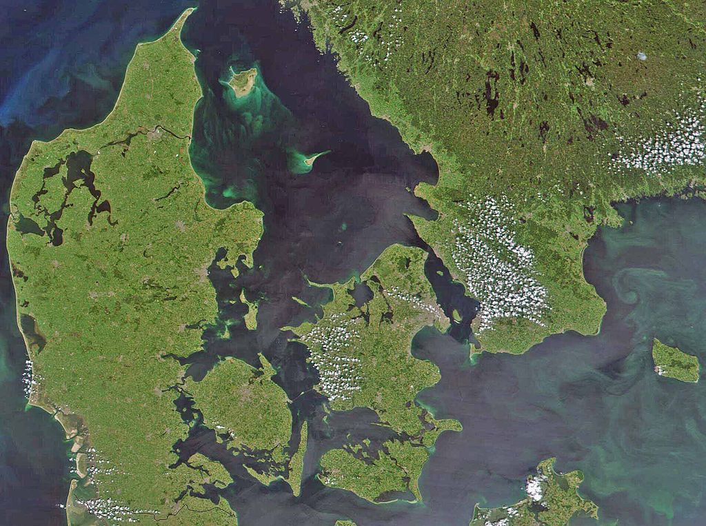
Satellite image of Denmark in July 2001. Cropped image, original taken from NASA's Visible Earth http://visibleearth.nasa.gov/view_rec.php?id=1909
- Interestingly, the Danish-German border is incorrectly placed. The line shown on the map has the correct shape, but is located c. 10 kilometres south of the current border. The line should have been positioned between the islands Rømø and Sylt in the west, and through the fjord to the east. Valentinian (talk) 17:09, 12 November 2006 (UTC)
Faila hronoloģija
Uzklikšķini uz datums/laiks kolonnā esošās saites, lai apskatītos, kā šis fails izskatījās tad.
| Datums/Laiks | Attēls | Izmēri | Dalībnieks | Komentārs | |
|---|---|---|---|---|---|
| tagadējais | 2008. gada 24. februāris, plkst. 11.39 | | 1 905 × 1 420 (190 KB) | XcepticZP | Color correction, ligthened up. Smaller file size due to better jpg compression. |
| 2005. gada 10. aprīlis, plkst. 17.22 |  | 1 905 × 1 420 (369 KB) | Hautala | {{PD-USGov-NASA}} Satellite image of Denmark in July 2001. Cropped image, original taken from NASA's Visible Earth http://visibleearth.nasa.gov/view_rec.php?id=1909 |
Faila lietojums
Šo failu izmanto šajā 1 lapā:
Globālais faila lietojums
Šīs Vikipēdijas izmanto šo failu:
- Izmantojums af.wikipedia.org
- Izmantojums arz.wikipedia.org
- Izmantojums az.wikipedia.org
- Izmantojums be.wikipedia.org
- Izmantojums bn.wikipedia.org
- Izmantojums ca.wikipedia.org
- Izmantojums ceb.wikipedia.org
- Izmantojums ce.wikipedia.org
- Izmantojums cs.wikipedia.org
- Izmantojums da.wikipedia.org
- Diskussion:København
- Diskussion:Odense
- Diskussion:Hjørring
- Diskussion:Faaborg
- Diskussion:Barneholm
- Svæveflyveklubber i Danmark
- Diskussion:Frederiksberg
- Diskussion:Ærøskøbing
- Diskussion:Frederikssund
- Diskussion:Kalundborg
- Diskussion:Nykøbing Falster
- Skabelon:Klik
- Diskussion:Nivå
- Bruger:Sir48/Sandkasse
- Diskussion:Frederiksværk
- Diskussion:Djævleø
- Diskussion:Frederikshavn
- Diskussion:Lillerød
- Diskussion:Helsingør
- Diskussion:Hørsholm
- Diskussion:Roskilde
- Diskussion:Visborg (by)
- Diskussion:Rønne
- Diskussion:Svendborg
- Diskussion:Slagelse
- Portal:Danmark
- Portal:Danmark/Introtekst
- Diskussion:Næstved
- Diskussion:Fugleholm
- Diskussion:Nexø
- Diskussion:Nakskov
- Diskussion:Allinge-Sandvig
- Diskussion:Sorø
- Diskussion:Rudkøbing
- Diskussion:Lysbro (Silkeborg)
- Skabelondiskussion:Kortpositioner/doc
- Diskussion:Holbæk
- Diskussion:Halsted
Skatīt šī faila pilno globālo izmantojumu.