Attēls:SDLIMITS.jpg

Šī priekšskata izmērs: 776 × 599 pikseļi. Citi izmēri: 311 × 240 pikseļi | 622 × 480 pikseļi | 994 × 768 pikseļi | 1 200 × 927 pikseļi.
Sākotnējais fails (1 200 × 927 pikseļi, faila izmērs: 165 KB, MIME tips: image/jpeg)
| Šis fails ir no Vikikrātuves. Tā apraksts no attēla lapas Vikikrātuvē ir parādīts zemāk. Vikikrātuve ir brīvi licencēta failu krātuve. Tu vari tai palīdzēt. |
Kopsavilkums
This Graphic is taken from http://msi.nga.mil/MSISiteContent/StaticFiles/Images/SDLIMITS.jpg
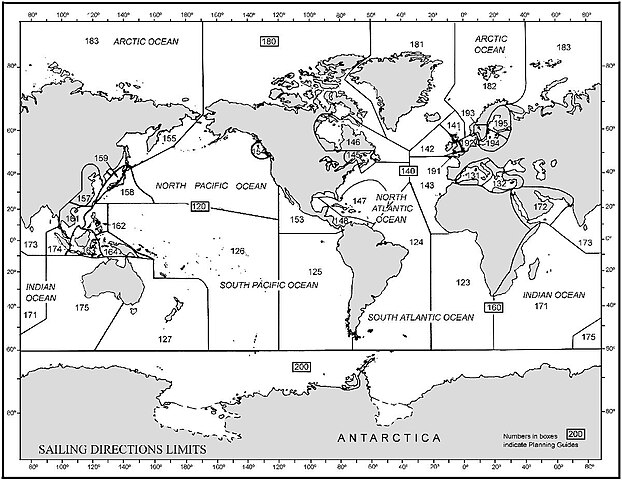
Graphic overview (world map) with limits of the Sailing Directions volumes of the U.S. NIMA (National Imagery and Mapping Agency) which can be downloaded starting at page http://permanent.access.gpo.gov/websites/pollux/pollux.nss.nima.mil/NAV_PUBS/SD/
The sailing directions can be found with this URL: [1] (replace the last three digits by the actual number)
Licence
This work is in the public domain in the United States because it is a work prepared by an officer or employee of the United States Government as part of that person’s official duties under the terms of Title 17, Chapter 1, Section 105 of the US Code.
Note: This only applies to original works of the Federal Government and not to the work of any individual U.S. state, territory, commonwealth, county, municipality, or any other subdivision. This template also does not apply to postage stamp designs published by the United States Postal Service since 1978. (See § 313.6(C)(1) of Compendium of U.S. Copyright Office Practices). It also does not apply to certain US coins; see The US Mint Terms of Use.
|
 | |
| This file has been identified as being free of known restrictions under copyright law, including all related and neighboring rights. | ||
Faila hronoloģija
Uzklikšķini uz datums/laiks kolonnā esošās saites, lai apskatītos, kā šis fails izskatījās tad.
| Datums/Laiks | Attēls | Izmēri | Dalībnieks | Komentārs | |
|---|---|---|---|---|---|
| tagadējais | 2006. gada 10. oktobris, plkst. 23.50 | | 1 200 × 927 (165 KB) | Ratzer | Graphic overview (world map) with limits of the Sailing Directions volumes of the U.S. NIMA (National Imagery and Mapping Agency) which can be downloaded starting at page http://permanent.access.gpo.gov/websites/pollux/pollux.nss.nima.mil/NAV_PUBS/SD/ |
Faila lietojums
Šo failu izmanto šajā 1 lapā:
Globālais faila lietojums
Šīs Vikipēdijas izmanto šo failu:
- Izmantojums ca.wikipedia.org
- Izmantojums de.wikipedia.org
- Izmantojums en.wikipedia.org
- Izmantojums es.wikipedia.org
- Izmantojums fr.wikipedia.org