Attēls:RossIslandMap.jpg

Šī priekšskata izmērs: 750 × 600 pikseļi. Citi izmēri: 300 × 240 pikseļi | 600 × 480 pikseļi | 1 000 × 800 pikseļi.
Sākotnējais fails (1 000 × 800 pikseļi, faila izmērs: 166 KB, MIME tips: image/jpeg)
| Šis fails ir no Vikikrātuves. Tā apraksts no attēla lapas Vikikrātuvē ir parādīts zemāk. Vikikrātuve ir brīvi licencēta failu krātuve. Tu vari tai palīdzēt. |

|
This file has been superseded by Ross Island Map USGS 250k.png. It is recommended to use the other file. Please note that deleting superseded images requires consent.
|

|
Kopsavilkums
| Apraksts |
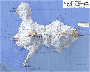
English: Topographic map of Ross Island, Antarctica (1:250,000 scale) Français : Carte topographique de l'île de Ross, Antarctique (échelle 1:250 000) Türkçe: Ross Adası'nın topografik haritası, Antarktika (Ölçek 1:250 000) |
| Datums | not specified |
| Avots | USGS Atlas of Antarctic Research |
| Autors | USGS |
| Citas versijas |
|


|
|
This file has been superseded by Ross Island Map USGS 250k.png. It is recommended to use the other file. Please note that deleting superseded images requires consent. Reason to use the other file: "higher resolution and rendered in PNG"
|
|
Licence
This image is in the public domain in the United States because it only contains materials that originally came from the United States Geological Survey, an agency of the United States Department of the Interior. For more information, see the official USGS copyright policy.
|
Faila hronoloģija
Uzklikšķini uz datums/laiks kolonnā esošās saites, lai apskatītos, kā šis fails izskatījās tad.
| Datums/Laiks | Attēls | Izmēri | Dalībnieks | Komentārs | |
|---|---|---|---|---|---|
| tagadējais | 2005. gada 15. janvāris, plkst. 03.30 | | 1 000 × 800 (166 KB) | GarciaB~commonswiki | Topographic map of Ross Island (1:250,000 scale) |
Faila lietojums
Šo failu izmanto šajās 8 lapās:
Globālais faila lietojums
Šīs Vikipēdijas izmanto šo failu:
- Izmantojums ar.wikipedia.org
- Izmantojums ast.wikipedia.org
- Izmantojums bg.wikipedia.org
- Izmantojums bs.wikipedia.org
- Izmantojums ca.wikipedia.org
- Izmantojums cs.wikipedia.org
- Izmantojums da.wikipedia.org
- Izmantojums de.wikipedia.org
- Izmantojums el.wikipedia.org
- Izmantojums en.wikipedia.org
- Izmantojums eo.wikipedia.org
- Izmantojums es.wikipedia.org
- Izmantojums et.wikipedia.org
- Izmantojums fa.wikipedia.org
- Izmantojums fi.wikipedia.org
- Izmantojums fr.wikipedia.org
- Izmantojums he.wikipedia.org
Skatīt šī faila pilno globālo izmantojumu.