Attēls:Roman expansion 264 BC Shepherd.jpg

Sākotnējais fails (2 302 × 1 812 pikseļi, faila izmērs: 873 KB, MIME tips: image/jpeg)
| Šis fails ir no Vikikrātuves. Tā apraksts no attēla lapas Vikikrātuvē ir parādīts zemāk. Vikikrātuve ir brīvi licencēta failu krātuve. Tu vari tai palīdzēt. |
This image was copied from wikipedia:de. The original description was:
| Apraksts |
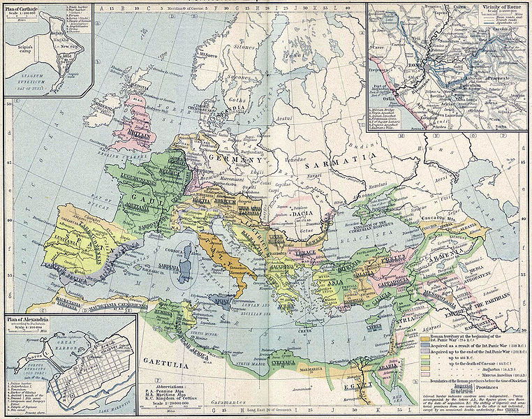
English: Roman territory, from the beginning of the 1st punic war (264 B.C.) to the death of Diocletian
Deutsch: Römisches Reich vom Beginn des 1. Punischen Kriegs (264 v.Chr.) bis zum Tod von Diokletian (312) im Historischen Atlas von William R. Shepherd (1923) |
| Datums | 1923 |
| Avots | "Historical Atlas" by William R. Shepherd, New York, Henry Holt and Company |
| Autors | William R. Shepherd |
| Citas versijas |
|
This work is in the public domain in its country of origin and other countries and areas where the copyright term is the author's life plus 70 years or fewer.
| |
| This file has been identified as being free of known restrictions under copyright law, including all related and neighboring rights. | |
| date/time | username | edit summary |
|---|---|---|
| 18:08, 21. Feb 2005 | Benowar | ("Historical Atlas" by William R. Shepherd, New York, Henry Holt and Company, 1923 PUBLIC DOMAIN) |
Faila hronoloģija
Uzklikšķini uz datums/laiks kolonnā esošās saites, lai apskatītos, kā šis fails izskatījās tad.
| Datums/Laiks | Attēls | Izmēri | Dalībnieks | Komentārs | |
|---|---|---|---|---|---|
| tagadējais | 2006. gada 18. aprīlis, plkst. 20.08 | | 2 302 × 1 812 (873 KB) | Crux | verbesserte Version |
| 2006. gada 18. aprīlis, plkst. 19.53 |  | 2 302 × 1 812 (767 KB) | Crux | This image was copied from wikipedia:de. The original description was: {{Information| |Description=Roman territory at the beginning of the 1st punic war (264 B.C.) |Source="Historical Atlas" by William R. Shepherd, New York, Henry Holt and Company |Date= |
Faila lietojums
Šo failu izmanto šajā 1 lapā:
Globālais faila lietojums
Šīs Vikipēdijas izmanto šo failu:
- Izmantojums ast.wikipedia.org
- Izmantojums ba.wikipedia.org
- Izmantojums bn.wikipedia.org
- Izmantojums br.wikipedia.org
- Izmantojums ca.wikipedia.org
- Izmantojums de.wikipedia.org
- Izmantojums de.wikibooks.org
- Izmantojums en.wikipedia.org
- Izmantojums es.wikipedia.org
- Izmantojums fr.wikipedia.org
- Izmantojums fy.wikipedia.org
- Izmantojums it.wikipedia.org
- Izmantojums it.wikibooks.org
- Izmantojums mk.wikipedia.org
- Izmantojums mwl.wikipedia.org
- Izmantojums pnb.wikipedia.org
- Izmantojums pt.wikipedia.org
- Izmantojums ru.wikipedia.org
- Izmantojums sa.wikipedia.org
- Izmantojums skr.wikipedia.org
- Izmantojums sk.wikipedia.org
- Izmantojums sl.wikipedia.org
- Izmantojums sq.wikipedia.org
- Izmantojums ur.wikipedia.org
- Izmantojums vi.wikipedia.org
- Izmantojums zh.wikipedia.org