Attēls:Prussia (political map before 1905).jpg

Šī priekšskata izmērs: 800 × 459 pikseļi. Citi izmēri: 320 × 184 pikseļi | 640 × 367 pikseļi | 1 024 × 588 pikseļi | 1 280 × 735 pikseļi | 2 560 × 1 469 pikseļi | 4 495 × 2 580 pikseļi.
Sākotnējais fails (4 495 × 2 580 pikseļi, faila izmērs: 2,31 MB, MIME tips: image/jpeg)
| Šis fails ir no Vikikrātuves. Tā apraksts no attēla lapas Vikikrātuvē ir parādīts zemāk. Vikikrātuve ir brīvi licencēta failu krātuve. Tu vari tai palīdzēt. |
| Apraksts |
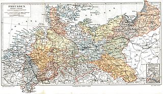
Deutsch: Das Königreich Preussen mit seinen Provinzen um 1900
English: Kingdom of Prussia and its provinces around 1900
Français : Royaume de Prusse et ses provinces en 1900 |
|||||
| Avots | Meyers Konversationslexikon, 5. Auflage | |||||
| Autors | ||||||
| Atļauja: (Šī faila izmantošana citur) |
|

.jpg?uselang=lv)
Faila hronoloģija
Uzklikšķini uz datums/laiks kolonnā esošās saites, lai apskatītos, kā šis fails izskatījās tad.
| Datums/Laiks | Attēls | Izmēri | Dalībnieks | Komentārs | |
|---|---|---|---|---|---|
| tagadējais | 2005. gada 5. septembris, plkst. 23.28 | | 4 495 × 2 580 (2,31 MB) | Alexander Fischer | removed yellowed background and commercial inscription |
| 2005. gada 6. aprīlis, plkst. 19.31 |  | 4 495 × 2 580 (1,31 MB) | Kirk979 |
Faila lietojums
Šo failu izmanto šajā 1 lapā:
Globālais faila lietojums
Šīs Vikipēdijas izmanto šo failu:
- Izmantojums ar.wikipedia.org
- Izmantojums ast.wikipedia.org
- Izmantojums azb.wikipedia.org
- Izmantojums be-tarask.wikipedia.org
- Izmantojums be.wikipedia.org
- Izmantojums br.wikipedia.org
- Izmantojums ca.wikipedia.org
- Izmantojums cs.wikipedia.org
- Izmantojums de.wikipedia.org
- Izmantojums en.wikipedia.org
- Izmantojums eo.wikipedia.org
- Izmantojums es.wikipedia.org
- Izmantojums et.wikipedia.org
- Izmantojums fi.wikipedia.org
- Izmantojums fr.wikipedia.org
- Izmantojums fy.wikipedia.org
- Izmantojums gcr.wikipedia.org
- Izmantojums gl.wikipedia.org
- Izmantojums id.wikipedia.org
- Izmantojums it.wikipedia.org
- Izmantojums it.wiktionary.org
- Izmantojums jv.wikipedia.org
- Izmantojums lb.wikipedia.org
- Izmantojums nl.wikipedia.org
- Izmantojums no.wikipedia.org
- Izmantojums pl.wikipedia.org
- Izmantojums pt.wikipedia.org
- Izmantojums ru.wikipedia.org
- Izmantojums simple.wikipedia.org
- Izmantojums sv.wikipedia.org
- Izmantojums tr.wikipedia.org
- Izmantojums uk.wikipedia.org
- Izmantojums vi.wikipedia.org
- Izmantojums zh.wikipedia.org
.jpg)