Attēls:PNW-straits.jpg
Augstāka izšķirtspēja nav pieejama.
PNW-straits.jpg (336 × 396 pikseļi, faila izmērs: 128 KB, MIME tips: image/jpeg)
| Šis fails ir no Vikikrātuves. Tā apraksts no attēla lapas Vikikrātuvē ir parādīts zemāk. Vikikrātuve ir brīvi licencēta failu krātuve. Tu vari tai palīdzēt. |
Kopsavilkums
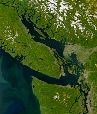
| Apraksts | Satellite image of the Strait of Georgia, Strait of Juan de Fuca, and surrounding region. The image was acquired by the Sea-viewing Wide Field-of-view Sensor (SeaWiFS) on August 9, 2001. Original image cropped to highlight the Strait of Georgia. |
| Datums | |
| Avots | NASAEarth Observatory, http://earthobservatory.nasa.gov/Newsroom/NewImages/images.php3?img_id=5051 |
| Autors | The SeaWiFS Project, NASA/Goddard Space Flight Center, and ORBIMAGE |
Licence
| This image is from the Sea-viewing Wide Field-of-view Sensor (SeaWiFS) Project and more than 5 years old.
Satellite data captured by the SeaWIFS sensor are released into the public domain 5 years after capture. Data less than five years old can be re-used only for educational or scientific purposes; any commercial use of such images must be coordinated with GeoEye. [1] |
| This work has been released into the public domain by its copyright holder, GeoEye. This applies worldwide. In some countries this may not be legally possible; if so: GeoEye grants anyone the right to use this work for any purpose, without any conditions, unless such conditions are required by law.
|
Faila hronoloģija
Uzklikšķini uz datums/laiks kolonnā esošās saites, lai apskatītos, kā šis fails izskatījās tad.
| Datums/Laiks | Attēls | Izmēri | Dalībnieks | Komentārs | |
|---|---|---|---|---|---|
| tagadējais | 2008. gada 22. aprīlis, plkst. 09.55 | | 336 × 396 (128 KB) | Pfly | {{Information |Description=Satellite image of the Strait of Georgia, Strait of Juan de Fuca, and surrounding region. The image was acquired by the Sea-viewing Wide Field-of-view Sensor (SeaWiFS) on |
Faila lietojums
Šo failu izmanto šajā 1 lapā:
Globālais faila lietojums
Šīs Vikipēdijas izmanto šo failu:
- Izmantojums ar.wikipedia.org
- Izmantojums ast.wikipedia.org
- Izmantojums az.wikipedia.org
- Izmantojums br.wikipedia.org
- Izmantojums ca.wikipedia.org
- Izmantojums cv.wikipedia.org
- Izmantojums de.wikipedia.org
- Izmantojums en.wikipedia.org
- Izmantojums eo.wikipedia.org
- Izmantojums es.wikipedia.org
- Izmantojums fa.wikipedia.org
- Izmantojums fi.wikipedia.org
- Izmantojums fr.wikipedia.org
- Izmantojums fr.wiktionary.org
- Izmantojums fy.wikipedia.org
- Izmantojums he.wikipedia.org
- Izmantojums id.wikipedia.org
- Izmantojums is.wikipedia.org
- Izmantojums it.wikipedia.org
- Izmantojums ja.wikipedia.org
- Izmantojums ko.wikipedia.org
- Izmantojums mhr.wikipedia.org
- Izmantojums mk.wikipedia.org
- Izmantojums ms.wikipedia.org
- Izmantojums nl.wikipedia.org
- Izmantojums no.wikipedia.org
- Izmantojums pl.wikipedia.org
- Izmantojums pt.wikipedia.org
- Izmantojums ru.wikipedia.org
- Izmantojums sh.wikipedia.org
- Izmantojums tr.wikipedia.org
- Izmantojums uk.wikipedia.org
- Izmantojums ur.wikipedia.org
- Izmantojums vi.wikipedia.org
- Izmantojums zh.wikipedia.org