Attēls:Mauryan Empire Map.gif
Mauryan_Empire_Map.gif (400 × 337 pikseļi, faila izmērs: 11 KB, MIME tips: image/gif)
Faila hronoloģija
Uzklikšķini uz datums/laiks kolonnā esošās saites, lai apskatītos, kā šis fails izskatījās tad.
| Datums/Laiks | Attēls | Izmēri | Dalībnieks | Komentārs | |
|---|---|---|---|---|---|
| tagadējais | 2016. gada 25. marts, plkst. 03.16 |  | 400 × 337 (11 KB) | LouisAragon | rv, changes made by a banned user. |
| 2007. gada 23. aprīlis, plkst. 04.14 |  | 400 × 337 (11 KB) | Jagged 85 | ||
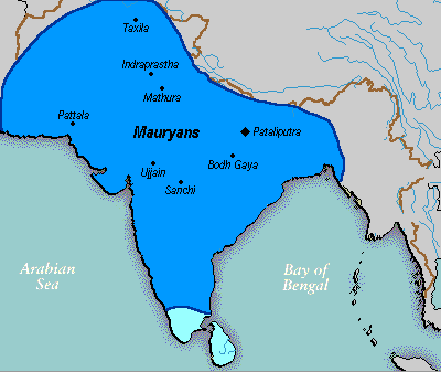
| 2006. gada 14. decembris, plkst. 02.02 |  | 400 × 337 (11 KB) | Electionworld | {{ew|en|Vastu}} {{ShouldBeSVG}} ==Description== A poltical map of the Mauryan Empire, including notable cities, such as the capital Pataliputra, and site of the Buddha's enlightenment. ===Key=== Dark blue represents the extend of the Maur |
Faila lietojums
Šo failu izmanto šajās 2 lapās:
Globālais faila lietojums
Šīs Vikipēdijas izmanto šo failu:
- Izmantojums anp.wikipedia.org
- Izmantojums bh.wikipedia.org
- Izmantojums bn.wikipedia.org
- Izmantojums bpy.wikipedia.org
- Izmantojums ca.wikipedia.org
- Izmantojums cs.wikipedia.org
- Izmantojums cy.wikipedia.org
- Izmantojums da.wikipedia.org
- Izmantojums en.wikipedia.org
- Izmantojums eo.wikipedia.org
- Izmantojums fa.wikipedia.org
- Izmantojums fi.wikipedia.org
- Izmantojums fi.wikibooks.org
- Izmantojums fr.wikipedia.org
- Izmantojums gu.wikipedia.org
- Izmantojums he.wikipedia.org
- Izmantojums hi.wikipedia.org
- Izmantojums it.wikipedia.org
- Izmantojums ka.wikipedia.org
- Izmantojums ko.wikipedia.org
- Izmantojums la.wikipedia.org
- Izmantojums lt.wikipedia.org
- Izmantojums ml.wikipedia.org
- Izmantojums mr.wikipedia.org
- Izmantojums ne.wikipedia.org
- Izmantojums nl.wikipedia.org
- Izmantojums no.wikipedia.org
Skatīt šī faila pilno globālo izmantojumu.


