Attēls:Map of Maryland highlighting Baltimore City.svg

Size of this PNG preview of this SVG file: 800 × 419 pikseļi. Citi izmēri: 320 × 167 pikseļi | 640 × 335 pikseļi | 1 024 × 536 pikseļi | 1 280 × 670 pikseļi | 2 560 × 1 340 pikseļi | 3 858 × 2 019 pikseļi.
Sākotnējais fails (SVG fails, definētais izmērs 3 858 × 2 019 pikseļi, faila izmērs: 139 KB)
| Šis fails ir no Vikikrātuves. Tā apraksts no attēla lapas Vikikrātuvē ir parādīts zemāk. Vikikrātuve ir brīvi licencēta failu krātuve. Tu vari tai palīdzēt. |
Kopsavilkums
| Apraksts |
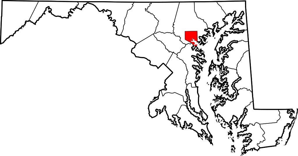
English: This is a locator map showing Baltimore in Maryland. For more information, see Commons:United States county locator maps. |
| Datums | |
| Avots |
Paša darbs: English: The maps use data from nationalatlas.gov, specifically countyp020.tar.gz on the Raw Data Download page. The maps also use state outline data from statesp020.tar.gz. The Florida maps use hydrogm020.tar.gz to display Lake Okeechobee. |
| Autors | David Benbennick |
Licence
| I, the copyright holder of this work, release this work into the public domain. This applies worldwide. In some countries this may not be legally possible; if so: I grant anyone the right to use this work for any purpose, without any conditions, unless such conditions are required by law. |
Faila hronoloģija
Uzklikšķini uz datums/laiks kolonnā esošās saites, lai apskatītos, kā šis fails izskatījās tad.
| Datums/Laiks | Attēls | Izmēri | Dalībnieks | Komentārs | |
|---|---|---|---|---|---|
| tagadējais | 2010. gada 6. marts, plkst. 20.56 | | 3 858 × 2 019 (139 KB) | Tom | Reverted to version as of 12:48, 12 February 2006 - inconsistent with other counties in state |
| 2008. gada 10. augusts, plkst. 04.03 |  | 3 858 × 2 019 (226 KB) | AMK1211 | {{Information |Description= |Source= |Date= |Author= |Permission= |other_versions= }} | |
| 2006. gada 12. februāris, plkst. 15.48 |  | 3 858 × 2 019 (139 KB) | David Benbennick | {{subst:User:Dbenbenn/clm|county=Baltimore City|state=Maryland|type=city}} |
Faila lietojums
Šo failu izmanto šajā 1 lapā:
Globālais faila lietojums
Šīs Vikipēdijas izmanto šo failu:
- Izmantojums ang.wikipedia.org
- Izmantojums ar.wikipedia.org
- Izmantojums arz.wikipedia.org
- Izmantojums ast.wikipedia.org
- Izmantojums bn.wikipedia.org
- Izmantojums br.wikipedia.org
- Izmantojums ca.wikipedia.org
- Izmantojums cy.wikipedia.org
- Izmantojums de.wikipedia.org
- Izmantojums diq.wikipedia.org
- Izmantojums el.wikipedia.org
- Izmantojums en.wikipedia.org
- Izmantojums eo.wikipedia.org
- Izmantojums es.wikipedia.org
- Izmantojums et.wikipedia.org
- Izmantojums eu.wikipedia.org
- Izmantojums fa.wikipedia.org
- Izmantojums fi.wikipedia.org
- Izmantojums fo.wikipedia.org
- Izmantojums fr.wikipedia.org
- Izmantojums ga.wikipedia.org
- Izmantojums gl.wikipedia.org
- Izmantojums he.wikipedia.org
- Izmantojums hu.wikipedia.org
- Izmantojums hy.wikipedia.org
- Izmantojums id.wikipedia.org
- Izmantojums ilo.wikipedia.org
- Izmantojums incubator.wikimedia.org
- Izmantojums io.wikipedia.org
- Izmantojums it.wikipedia.org
- Izmantojums ja.wikipedia.org
- Izmantojums kab.wikipedia.org
- Izmantojums kn.wikipedia.org
- Izmantojums ko.wikipedia.org
Skatīt šī faila pilno globālo izmantojumu.