Attēls:Low-Island-location-map.png

Šī priekšskata izmērs: 800 × 548 pikseļi. Citi izmēri: 320 × 219 pikseļi | 640 × 439 pikseļi | 1 024 × 702 pikseļi | 1 280 × 877 pikseļi | 1 669 × 1 144 pikseļi.
Sākotnējais fails (1 669 × 1 144 pikseļi, faila izmērs: 150 KB, MIME tips: image/png)
| Šis fails ir no Vikikrātuves. Tā apraksts no attēla lapas Vikikrātuvē ir parādīts zemāk. Vikikrātuve ir brīvi licencēta failu krātuve. Tu vari tai palīdzēt. |
Kopsavilkums
| Apraksts |
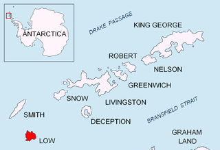
English: Location map of Low Island in the South Shetland Islands. |
| Datums | |
| Avots | Paša darbs |
| Autors | Apcbg |
Licence
Es, šī darba autortiesību īpašnieks, publicēju to saskaņā ar šīm licencēm:
Šis fails tiek izplatīts saskaņā ar licences Creative Commons Atsauce-Līdzīgi Noteikumi 3.0 Vispārējiem noteikumiem.
- Jūs varat brīvi:
- koplietot – kopēt, izplatīt un pārraidīt darbu
- remiksēt – pielāgot darbu
- Saskaņā ar šādiem nosacījumiem:
- atsaucoties – Tev ir jānorāda autors, saite uz licenci un to, vai veiktas kādas izmaiņas. To var darīt jebkādā saprātīgā veidā, bet ne tādā, kas norādītu, ka licencētājs atbalsta tevi vai veidu, kā tu izmanto šo darbu.
- nemainot licenci – Ja tu miksē, pārveido vai izmanto materiālu, tev savs devums jāpublicē ar to pašu vai saderīgu licenci kā oriģināls.

|
Ir dota atļauja kopēt, izplatīt un/vai pārveidot šo dokumentu saskaņā ar GNU brīvās dokumentācijas licences, versijas 1.2 vai jebkuras vēlākas versijas, ko publiskojis Brīvās programmatūras fonds nosacījumiem; bez nemainīgajām sadaļā, priekšējā un aizmugurēja'vāka tekstiem. Licences kopija ir iekļauta sadaļā ar nosaukumu GNU brīvās dokumentācijas licence. |
Jūs varat izvēlēties licenci pēc jūsu vēlmes.
Faila hronoloģija
Uzklikšķini uz datums/laiks kolonnā esošās saites, lai apskatītos, kā šis fails izskatījās tad.
| Datums/Laiks | Attēls | Izmēri | Dalībnieks | Komentārs | |
|---|---|---|---|---|---|
| tagadējais | 2010. gada 24. augusts, plkst. 20.29 | | 1 669 × 1 144 (150 KB) | Apcbg | + location in Antarctica |
| 2010. gada 27. aprīlis, plkst. 21.48 |  | 1 669 × 1 144 (5,47 MB) | Apcbg | {{Information |Description={{en|1=Location map of Low Island in the South Shetland Islands.}} |Source={{own}} |Author=Apcbg |Date=2010-04-27 |Permission= |other_versions= }} Category:Maps of Antarctica |
Faila lietojums
Šo failu izmanto šajā 1 lapā:
Globālais faila lietojums
Šīs Vikipēdijas izmanto šo failu:
- Izmantojums az.wikipedia.org
- Izmantojums bg.wikipedia.org
- Izmantojums ca.wikipedia.org
- Izmantojums ceb.wikipedia.org
- Izmantojums en.wikipedia.org
- Low Island (South Shetland Islands)
- Solnik Point
- Kazichene Cove
- Teshel Cove
- Malina Cove
- Cape Wallace
- Jameson Point
- Limets Peninsula
- Prisad Island
- Beslen Island
- Zebil Island
- Glumche Island
- Lyutibrod Rocks
- Smochevo Cove
- Ugorelets Point
- Presnakov Island
- Aurelia Island
- Venev Point
- Mateev Point
- Groma Rock
- Dioptra Island
- Izmantojums es.wikipedia.org
- Izmantojums eu.wikipedia.org
- Izmantojums he.wikipedia.org
- Izmantojums it.wikipedia.org
- Izmantojums ja.wikipedia.org
- Izmantojums ko.wikipedia.org
- Izmantojums nn.wikipedia.org
- Izmantojums pl.wikipedia.org
- Izmantojums ru.wikipedia.org
- Izmantojums uk.wikipedia.org
- Izmantojums www.wikidata.org
- Izmantojums zh.wikipedia.org
Skatīt šī faila pilno globālo izmantojumu.