Attēls:Lithuania Minor.png
Šī priekšskata izmērs: 800 × 519 pikseļi. Citi izmēri: 320 × 208 pikseļi | 640 × 415 pikseļi | 1 024 × 665 pikseļi | 1 471 × 955 pikseļi.
Sākotnējais fails (1 471 × 955 pikseļi, faila izmērs: 3,56 MB, MIME tips: image/png)
| Šis fails ir no Vikikrātuves. Tā apraksts no attēla lapas Vikikrātuvē ir parādīts zemāk. Vikikrātuve ir brīvi licencēta failu krātuve. Tu vari tai palīdzēt. |
Kopsavilkums
| Apraksts |
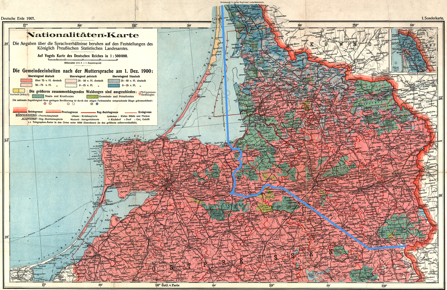
English: The language situation in Lithuania Minor (German: Kleinlitauen) in 1900. The blue line indicates the extent of the Lithuanian language are in 1876 as described by Friedrich Kurschat in 1876:
|
| Datums | (UTC) |
| Avots | |
| Autors |
|
| This is a retouched picture, which means that it has been digitally altered from its original version. Modifications: Added the 1876 border between the Lithuanian and German language areas as described by Friedrich Kurschat in 1876; cropped. The original can be viewed here: Ethnic map East Prussia 1907.jpeg:
|
Licence
|
The author died in 1952, so this work is in the public domain in its country of origin and other countries and areas where the copyright term is the author's life plus 70 years or fewer. Šis attēls ir publiskā lietošanā ASV teritorijā saskaņā ar ASV likumiem un normatīvajiem aktiem, jo ir pirmo reizi publicēts pirms 1929. gada 1. janvāra, vai ir publiskā lietošanā saskaņā ar citām juridiskām prasībām.. | |
| This file has been identified as being free of known restrictions under copyright law, including all related and neighboring rights. | |
Original upload log
This image is a derivative work of the following images:
- File:Ethnic_map_East_Prussia_1907.jpeg licensed with PD-old
- 2009-04-25T16:53:31Z Fentener van Vlissingen 1682x2139 (4979293 Bytes) == Summary == {{Information |Description={{de|Nationalitäten-Karte der Provinz Ostpreussen / auf Grund amtlicher Angaben entworfen von Paul Langhans}} {{en|Nationalities map of the Province of East Prussia / on the basis of
Uploaded with derivativeFX
Faila hronoloģija
Uzklikšķini uz datums/laiks kolonnā esošās saites, lai apskatītos, kā šis fails izskatījās tad.
| Datums/Laiks | Attēls | Izmēri | Dalībnieks | Komentārs | |
|---|---|---|---|---|---|
| tagadējais | 2009. gada 19. septembris, plkst. 19.08 | | 1 471 × 955 (3,56 MB) | Fentener van Vlissingen | {{Information |Description={{en|The language situation in Lithuania Minor (German: ''Kleinlitauen'') in 1900. The blue line indicates the extent of the Lithuanian language are in 1876 as described by Friedrich Kurschat in 1876: :''Die Grenze des littauis |
Faila lietojums
Šo failu izmanto šajā 1 lapā:
Globālais faila lietojums
Šīs Vikipēdijas izmanto šo failu:
- Izmantojums de.wikipedia.org
- Izmantojums uk.wikipedia.org