Attēls:Johs. Mejer 1650.JPG

Šī priekšskata izmērs: 771 × 599 pikseļi. Citi izmēri: 309 × 240 pikseļi | 617 × 480 pikseļi | 988 × 768 pikseļi | 1 280 × 995 pikseļi | 2 560 × 1 990 pikseļi | 2 962 × 2 303 pikseļi.
Sākotnējais fails (2 962 × 2 303 pikseļi, faila izmērs: 5,04 MB, MIME tips: image/jpeg)
| Šis fails ir no Vikikrātuves. Tā apraksts no attēla lapas Vikikrātuvē ir parādīts zemāk. Vikikrātuve ir brīvi licencēta failu krātuve. Tu vari tai palīdzēt. |
Kopsavilkums

.jpg)

Licence
Es, šī darba autortiesību īpašnieks, publicēju to saskaņā ar šo licenci:
| This file is made available under the Creative Commons CC0 1.0 Universal Public Domain Dedication. | |
| The person who associated a work with this deed has dedicated the work to the public domain by waiving all of their rights to the work worldwide under copyright law, including all related and neighboring rights, to the extent allowed by law. You can copy, modify, distribute and perform the work, even for commercial purposes, all without asking permission.
|
Faila hronoloģija
Uzklikšķini uz datums/laiks kolonnā esošās saites, lai apskatītos, kā šis fails izskatījās tad.
| Datums/Laiks | Attēls | Izmēri | Dalībnieks | Komentārs | |
|---|---|---|---|---|---|
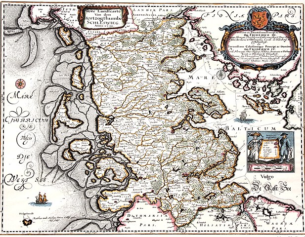
| tagadējais | 2011. gada 25. aprīlis, plkst. 16.08 | | 2 962 × 2 303 (5,04 MB) | Calvin~commonswiki | {{Information |Description ={{en|1=Map of the Duchy of Schleswig 1650. The map shows the original area of the duchy. Kort over hertugdømmet Slesvig. Kortet viser hertugdømmets oprindelige udstrækning.}} |Source =Map by Johannes Mejer, Husum, |
Faila lietojums
Šo failu izmanto šajā 1 lapā:
Globālais faila lietojums
Šīs Vikipēdijas izmanto šo failu:
- Izmantojums da.wikipedia.org
- Izmantojums de.wikipedia.org
- Izmantojums en.wikipedia.org
- Izmantojums hu.wikipedia.org
- Izmantojums is.wikipedia.org
- Izmantojums nl.wikipedia.org