Attēls:Holy Alliance.png
Augstāka izšķirtspēja nav pieejama.
Holy_Alliance.png (262 × 197 pikseļi, faila izmērs: 4 KB, MIME tips: image/png)
| Šis fails ir no Vikikrātuves. Tā apraksts no attēla lapas Vikikrātuvē ir parādīts zemāk. Vikikrātuve ir brīvi licencēta failu krātuve. Tu vari tai palīdzēt. |

|
File:Map of the Holy Alliance (1840).svg is a vector version of this file. It should be used in place of this PNG file when not inferior.
File:Holy Alliance.png → File:Map of the Holy Alliance (1840).svg
For more information, see Help:SVG. |
.svg) |
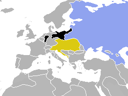
| Apraksts | Map of Europe, highlighting the Holy Alliance of 1815 | ||
| Datums | (UTC) | ||
| Avots | Cropped and colourised from Image:BlankMap-World-1840.png | ||
| Autors | OwenBlacker | ||
| Atļauja: (Šī faila izmantošana citur) |
|
Faila hronoloģija
Uzklikšķini uz datums/laiks kolonnā esošās saites, lai apskatītos, kā šis fails izskatījās tad.
| Datums/Laiks | Attēls | Izmēri | Dalībnieks | Komentārs | |
|---|---|---|---|---|---|
| tagadējais | 2009. gada 2. augusts, plkst. 18.01 | | 262 × 197 (4 KB) | Berillium | Reverted to version as of 14:59, 17 November 2007 merges |
| 2009. gada 2. augusts, plkst. 04.04 |  | 262 × 197 (6 KB) | Buonaparte69~commonswiki | Russia change to traditional 19th-century colour of green. | |
| 2007. gada 17. novembris, plkst. 17.59 |  | 262 × 197 (4 KB) | OwenBlacker | Correction: I'd forgotten to colourise the Rhenish exclave of Prussia | |
| 2007. gada 19. oktobris, plkst. 00.19 |  | 262 × 197 (4 KB) | OwenBlacker | {{Information |Description=Map of Europe, highlighting the Holy Alliance of 1815 |Source=Cropped and colourised from Image:BlankMap-World-1840.png |Date=~~~~~ |Author=~~~ |other_versions= |Licencing={{PD-user-w|en|Engli |
Faila lietojums
Šo failu neizmanto nevienā lapā.
Globālais faila lietojums
Šīs Vikipēdijas izmanto šo failu:
- Izmantojums en.wikipedia.org
- Izmantojums zh.wikipedia.org