Attēls:Hängebrücke am Berliner Höhenweg Nr 526, Zillertaler Alpen 2.JPG

Šī priekšskata izmērs: 800 × 542 pikseļi. Citi izmēri: 320 × 217 pikseļi | 640 × 433 pikseļi | 1 024 × 693 pikseļi | 1 280 × 867 pikseļi | 2 560 × 1 733 pikseļi | 4 205 × 2 847 pikseļi.
Sākotnējais fails (4 205 × 2 847 pikseļi, faila izmērs: 2,43 MB, MIME tips: image/jpeg)
| Šis fails ir no Vikikrātuves. Tā apraksts no attēla lapas Vikikrātuvē ir parādīts zemāk. Vikikrātuve ir brīvi licencēta failu krātuve. Tu vari tai palīdzēt. |
| Apraksts |
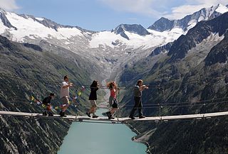
Deutsch: Drahtsteg Hängebrücke am Berliner Höhenweg Nr.526 in den Zillertaler Alpen auf einer Höhe von 2413 Metern über den Alelebach nahe der Olpererhütte. Im Tal liegt der Schlegeisspeicher.
English: Drahtsteg pedestrian hanging bridge, in the Zillertal Alps, Austria.
Français : La passerelle suspendue de Drahtsteg, dans les Alpes de Zillertal, en Autriche. |
| Datums | |
| Avots | Paša darbs |
| Autors | böhringer friedrich |
| Atļauja: (Šī faila izmantošana citur) |
Es, šī darba autortiesību īpašnieks, publicēju to saskaņā ar šo licenci: Šis fails tiek izplatīts saskaņā ar licences Creative Commons Atsauce-Līdzīgi Noteikumi 2.5 Vispārējiem noteikumiem.
|
This image was selected as picture of the day on Bengali Wikipedia.
|
| Camera location | | View this and other nearby images on: OpenStreetMap |
|---|
|
This image was selected as picture of the day on Vietnamese Wikipedia.
|
This Photo was taken by Böhringer Friedrich.
|
Feel free to use my photos, but please mention me as the author and if you want send me a message. or (rufre@lenz-nenning.at) |
| Annotations | This image is annotated: View the annotations at Commons |
This image has been assessed using the Quality image guidelines and is considered a Quality image.
|
Faila hronoloģija
Uzklikšķini uz datums/laiks kolonnā esošās saites, lai apskatītos, kā šis fails izskatījās tad.
| Datums/Laiks | Attēls | Izmēri | Dalībnieks | Komentārs | |
|---|---|---|---|---|---|
| tagadējais | 2011. gada 19. augusts, plkst. 21.44 | | 4 205 × 2 847 (2,43 MB) | Böhringer | {{Information |Description= {{de|Drahtsteg Hängebrücke am Berliner Höhenweg Nr.526 in den Zillertaler Alpen auf einer Höhe von 2413 Metern. Ihn erreicht man zu Fuß in 5 Minuten von der [[:de:Olpererhüt |
Faila lietojums
Šo failu izmanto šajā 1 lapā:
Globālais faila lietojums
Šīs Vikipēdijas izmanto šo failu:
- Izmantojums bn.wikipedia.org
- Izmantojums ca.wikipedia.org
- Izmantojums ceb.wikipedia.org
- Izmantojums da.wikipedia.org
- Izmantojums de.wikipedia.org
- Izmantojums en.wikipedia.org
- Izmantojums es.wikipedia.org
- Izmantojums et.wikipedia.org
- Izmantojums fr.wikipedia.org
- Izmantojums fr.wikiversity.org
- Izmantojums id.wikipedia.org
- Izmantojums mk.wikipedia.org
- Izmantojums nn.wikipedia.org
- Izmantojums no.wikipedia.org
- Izmantojums ro.wikipedia.org
- Izmantojums sr.wikipedia.org
- Izmantojums sv.wikipedia.org
- Izmantojums tt.wikipedia.org
- Izmantojums vi.wikipedia.org
- Izmantojums www.wikidata.org