Attēls:Gulf of Saint Lawrence.jpg
Augstāka izšķirtspēja nav pieejama.
Gulf_of_Saint_Lawrence.jpg (734 × 456 pikseļi, faila izmērs: 99 KB, MIME tips: image/jpeg)
| Šis fails ir no Vikikrātuves. Tā apraksts no attēla lapas Vikikrātuvē ir parādīts zemāk. Vikikrātuve ir brīvi licencēta failu krātuve. Tu vari tai palīdzēt. |
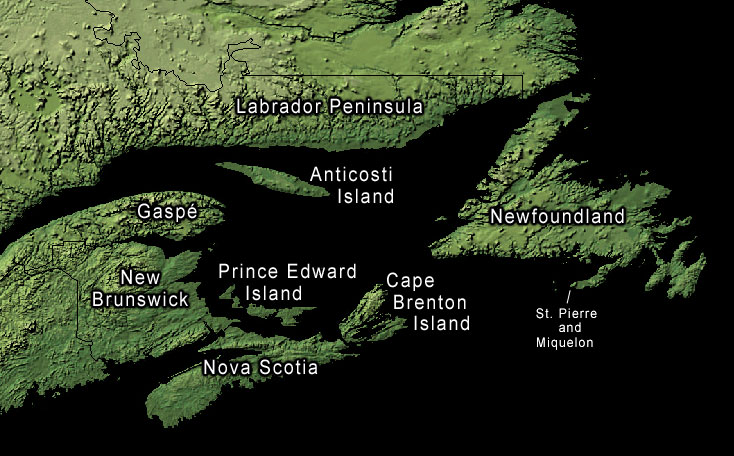
Kopsavilkums
Land-cover imagery from USGS's National Map Server archive copy at the Wayback Machine. Photoshop file with layers is located here in case any modifications or translations are needed.
Licence
This work is in the public domain in the United States because it is a work prepared by an officer or employee of the United States Government as part of that person’s official duties under the terms of Title 17, Chapter 1, Section 105 of the US Code.
Note: This only applies to original works of the Federal Government and not to the work of any individual U.S. state, territory, commonwealth, county, municipality, or any other subdivision. This template also does not apply to postage stamp designs published by the United States Postal Service since 1978. (See § 313.6(C)(1) of Compendium of U.S. Copyright Office Practices). It also does not apply to certain US coins; see The US Mint Terms of Use.
|
 | |
| This file has been identified as being free of known restrictions under copyright law, including all related and neighboring rights. | ||
Original upload log
The original description page was here. All following user names refer to en.wikipedia.
- 2006-01-30 20:43 Kelisi 734×456× (74652 bytes) same, with spelling correction
- 2005-10-23 17:10 Interiot 734×456× (101750 bytes) inc font size of "Gaspé"
- 2005-10-23 15:38 Interiot 734×456× (101801 bytes) more font tweaks
- 2005-10-23 15:32 Interiot 734×457× (101689 bytes) larger font
- 2005-10-23 15:26 Interiot 781×481× (111492 bytes) Map of the [[Gulf of Saint Lawrence]]. Land-cover imagery from [[USGS]]'s [http://nmviewogc.cr.usgs.gov/viewer.htm National Map Server].
Faila hronoloģija
Uzklikšķini uz datums/laiks kolonnā esošās saites, lai apskatītos, kā šis fails izskatījās tad.
| Datums/Laiks | Attēls | Izmēri | Dalībnieks | Komentārs | |
|---|---|---|---|---|---|
| tagadējais | 2012. gada 18. septembris, plkst. 01.23 | | 734 × 456 (99 KB) | OgreBot | (BOT): Reverting to most recent version before archival |
| 2012. gada 18. septembris, plkst. 01.23 |  | 734 × 456 (73 KB) | OgreBot | (BOT): Uploading old version of file from en.wikipedia; originally uploaded on 2006-01-30 20:43:20 by Kelisi | |
| 2012. gada 18. septembris, plkst. 01.23 |  | 734 × 456 (99 KB) | OgreBot | (BOT): Uploading old version of file from en.wikipedia; originally uploaded on 2005-10-23 15:38:39 by Interiot | |
| 2012. gada 18. septembris, plkst. 01.23 |  | 734 × 457 (99 KB) | OgreBot | (BOT): Uploading old version of file from en.wikipedia; originally uploaded on 2005-10-23 15:32:33 by Interiot | |
| 2012. gada 18. septembris, plkst. 01.23 |  | 781 × 481 (109 KB) | OgreBot | (BOT): Uploading old version of file from en.wikipedia; originally uploaded on 2005-10-23 15:26:46 by Interiot | |
| 2006. gada 29. janvāris, plkst. 11.05 |  | 734 × 456 (99 KB) | Kpjas | Land-cover imagery from USGS's [http://nmviewogc.cr.usgs.gov/viewer.htm National Map Server]. Photoshop file with layers is located [http://paperlined.org/apps/wikipedia/src_data/Gulf_of_Saint_Lawrence.psd here] in case any modifications or trans |
Faila lietojums
Šo failu izmanto šajā 1 lapā:
Globālais faila lietojums
Šīs Vikipēdijas izmanto šo failu:
- Izmantojums af.wikipedia.org
- Izmantojums az.wikipedia.org
- Izmantojums ba.wikipedia.org
- Izmantojums be.wikipedia.org
- Izmantojums bs.wikipedia.org
- Izmantojums ce.wikipedia.org
- Izmantojums cs.wikipedia.org
- Izmantojums el.wikipedia.org
- Izmantojums en.wikipedia.org
- Izmantojums fa.wikipedia.org
- Izmantojums fr.wikipedia.org
- Izmantojums he.wikipedia.org
- Izmantojums id.wikipedia.org
- Izmantojums it.wikipedia.org
- Izmantojums ko.wikipedia.org
- Izmantojums pl.wikipedia.org
- Izmantojums ro.wikipedia.org
- Izmantojums ru.wikipedia.org
- Izmantojums sh.wikipedia.org
- Izmantojums sk.wikipedia.org
- Izmantojums sr.wikipedia.org
- Izmantojums uk.wikipedia.org
- Izmantojums zh.wikipedia.org